
IMAGE OF THE WEEK
Are you blind to change?
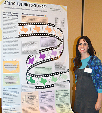
Carolyn Fish presents her award-winning poster “Are You Blind to Change? Evaluating the Influence of Change Blindness in Animated Choropleth Maps” at the Pennsylvania Geographic Society meeting. Photo by Kathy Cappelli.
GOOD NEWS
Cynthia Brewer gave a talk for GIS day: “Advanced Federal Map Design using GIS” at the Sixth Annual USACE Agency-Wide Global Virtual GIS Day for the U.S. Army Corps of Engineers.
Brian Tomaszewski (Ph.D. ’09) published a book: Geographic Information Systems (GIS) for Disaster Management
Azita Ranjbar has been awarded a two-year Ph.D. fellowship through the ZEIT-Stiftung Foundation’s Trajectories of Change programme.
Ann Myatt James successfully defended her dissertation “Feeding Hungry People: An Investigation of US Food Assistance Programs,” and she will be working at Bucknell University as a visiting assistant professor teaching economic geography for the spring 2015 semester.
NEWS
UROC lightening talks
The Undergraduate Research Opportunities Connection (UROC) program end-of-semester celebration is Tuesday, December 9 at 6:00 p.m. in 319 Walker Building. UROC students will give 5-minute lightning talks on their research projects.
Tschakert participates in COP20 side event: Climate Change Science Update: The Challenges for Robust Decision Making
Moderated by Leo Hickman, Met Office Hadley Centre, this event explored the challenges of making climate projections and linking damages from extreme weather events to changing emissions; risk management in the face of uncertainty; and the ethics of loss and damage.
Petra Tschakert noted that the IPCC Fifth Assessment Report (AR5) considers multidimensional vulnerability, explaining that this is linked to social frameworks where the more vulnerable have less capacity and fewer opportunities to adapt. She highlighted new qualitative modelling based on quantitative data, as well as value judgments, to demonstrate scenarios where adaptation is possible.
December 12 Facilitated discussion with Petra Tschakert and Chris Forest about the recently released Intergovernmental Panel on Climate Change (IPCC) reports and the current Lima Climate Change Convention, from 3:45 to 4:45 p.m. in 112 Walker Building
Nancy Tuana, Penn State Rock Ethics Institute, explained that as different countries set standards on dealing with climate risk, they should consider that there are value judgments embedded in both the science and the politics of climate change. She underscored gathering information on what the wider community values, and then engaging with the decision makers to model various scenarios that should be considered when creating strategies to manage risk.
PGS meeting honors faculty achievements, student research, geography community
The Pennsylvania Geographical Society (PGS) annual meeting, held in State College on November 7, 2014, brought together students, professors, and professionals in the field of geography to discuss their research. Featuring a poster contest, a paper contest, various sessions, and two guest speakers, this year’s conference honored four geographers for their work as educators or scholars in the field.
Fall GEOGRAPHY newsletter now available
The Fall 2014 issue of Penn State GEOGRAPHY is now available via mail, a digital version (PDF) or as html pages. Access the format of your choice here: http://www.geog.psu.edu/news/penn-state-geography-newsletter/fall-2014-newsletter
Recently (or soon to be) Published
“14 Exploring the Nature and Development of Expertise in Geography.” Space in Mind: Concepts for Spatial Learning and Education (2014): 281.
By Roger M. Downs
Ice storms generate spatially heterogeneous damage patterns at the watershed scale in forested landscapes
By Rachel E. Isaacs, Kirk M. Stueve, Charles W. Lafon, and Alan H. Taylor
In Ecosphere 2014 5:11, art141
The effects of large-scale disturbances play a pivotal role in shaping ecosystem structure and function. Interactions between disturbances and a multitude of biophysical factors at different scales generate spatially heterogeneous patterns of damage on vegetated landscapes. However, research on large-scale disturbances is often conducted at one spatial extent because of the challenges associated with quantifying patterns of damage in vegetation across multiple spatial extents. Consequently, the literature has identified many different and often conflicting biophysical controls of vegetation damage, which is likely a consequence of the historical and spatial contingency of particular geographic locations. We investigated the influence of biophysical factors and spatial extent of ice storm damage patterns across the entire Ouachita National Forest and in 65 individual watersheds.
DOG OF THE WEEK

Who is this dog? Who is his human?
Send your answer and/or a photo of your dog to geography@psu.edu for our mystery dog of the week!
