
IMAGE OF THE WEEK
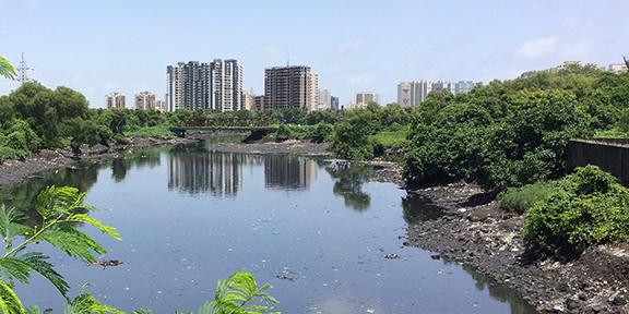 Aparna Parikh sends this photo from her fieldwork site around call center landscapes in Malad, a suburb located in the northern part of Mumbai, India.
GOOD NEWS
Tom Auer (M.S. ’09) has taken a new exciting job at Cornell as a GIS Developer.
Kimberly Struthers (MGIS) Received 2nd place at GIS in the Rockies for her poster presentation “Conservation strategy: where it matters most. Integrating demographics, socioeconomic, lifestyle and biodiversity.”
Send your good news to share to geography@psu.edu.
NEWS
October 2 Coffee Hour with Robert Cardillo “Succeeding in the Open”
In this discussion, Robert Cardillo, director of the National Geospatial-Intelligence Agency, deals with two topics: first, transparency, and how intelligence activities can be conducted in an increasingly open environment, and second, what skills are needed in this new, more open intelligence-gathering environment. NGA has been operating in a transparent environment for years. As James Clapper, the director of National Intelligence, has said, “Geospatial intelligence has a great advantage in our current environment because it is the most transparent of the collection disciplines.”
- 3:30 to 5:00 p.m.
- Refreshments are offered in 319 Walker Building at 3:30 p.m.
- The lecture begins in 112 Walker Building at 4:00 p.m.
- Coffee Hour To Go
- Next Week: Candace Brakewood “Don’t Miss the Bus: Quantifying the Impacts of Real-Time Information on Transit Ridership”
How do religion, ethics, and climate change fit together?
Question: Climate change is something that, until recently, was only discussed within the scientific community. But now others are getting involved from all types of disciplines, including religion and ethics. So what exactly does religion and ethics have to do with climate change?
IST professor part of effort to map aurora borealis using Twitter
The past few months have been exciting for followers of the aurora borealis, commonly known as the Northern Lights. Sizable solar storms have produced spectacular auroras that have been visible in a much larger area than usual, including in parts of Pennsylvania.
Ecology on the wing
Drones have been flying over the Ugalla Forest in western Tanzania. Far from being part of a military operation, these drones are being used to map chimpanzee habitat as part of an international research collaboration.
RECENTLY (OR SOON TO BE) PUBLISHED
Evaluating the effect of visually represented geodata uncertainty on decision-making: systematic review, lessons learned, and recommendations
By Christoph Kinkeldey, Alan M. MacEachren, Maria Riveiro & Jochen Schiewe in Cartography and Geographic Information Science
doi:10.1080/15230406.2015.1089792
For many years, uncertainty visualization has been a topic of research in several disparate fields, particularly in geographical visualization (geovisualization), information visualization, and scientific visualization. Multiple techniques have been proposed and implemented to visually depict uncertainty, but their evaluation has received less attention by the research community. In order to understand how uncertainty visualization influences reasoning and decision-making using spatial information in visual displays, this paper presents a comprehensive review of uncertainty visualization assessments from geovisualization and related fields.
Influence of protected areas on malaria prevalence in Sub-Saharan Africa
By Eric D. Taber and Erica A. H. Smithwick in Applied Geography doi:10.1016/j.apgeog.2015.09.001
Despite exponential growth in the number and extent of protected areas globally, their role within disease dynamics remains unclear. Protected areas shape many biophysical and social factors related to malaria prevalence such as land use-land cover, biodiversity, socioeconomic conditions, and human behavior. This work examines the extent to which protected areas influence Plasmodium falciparum malaria prevalence within surrounding human populations throughout Sub-Saharan Africa.
DOG OF THE WEEK

 Who are these dogs? Who is their human? Send your answer and/or a photo of your dog to geography@psu.edu for our mystery dog of the week!