
IMAGE OF THE WEEK
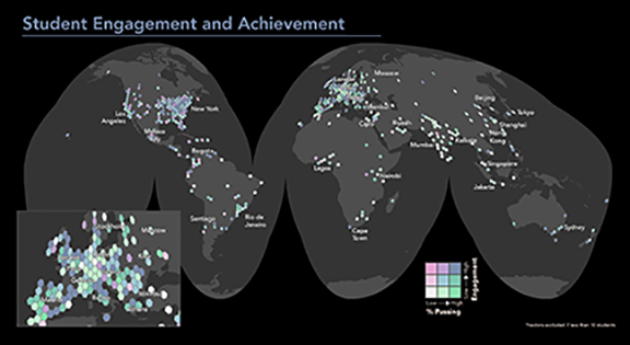 Mapping the location of the 49,000 students who take a MOOC called “Maps and the Geospatial Revolution,” revealed some interesting patterns. See related story below.
GOOD NEWS
The Population Association of America (PAA) has just announced that Stephen A. Matthews and two Penn State colleagues will be the next co-editors of its flagship journal, Demography.
Russ Hedberg received funding from the National Science Foundation for a doctoral dissertation research improvement grant.
Sterling Quinn accepted a job as assistant professor of Geography at Central Washington University, beginning September 2016.
Cynthia A. Brewer’s new edition of Designing Better Maps: A Guide for GIS Users, has been published by Esri.
Professor Emeritus Lucky Yapa’s son Sunil was interviewed on Late Night with Seth Myers about his novel, “Your Heart is a Muscle the Size of a Fist.”
Alumnus Vaclav Smil (Ph.D. ’69) was mentioned in Bill Gates book blog: https://www.gatesnotes.com/Books/Should-We-Eat-Meat
NEWS
Coffee Hour with Alton C. Byers
Impacts of the April 27, 2015 Nepal earthquake on four potentially dangerous glacial lakes in Nepal
On April 25, 2015, a magnitude 7.8 earthquake struck central Nepal, causing more than 8,000 deaths throughout the country. Two weeks later, a magnitude 7.3 aftershock caused further damage and uncertainty. Massive landslides wiped out entire villages, rivers were dammed by landslides, and the geologic and geomorphic integrity of high altitude mountains and glaciers was destabilized. Scientists throughout the world began to worry that the seismic activity could also result in new glacial lake outburst floods (GLOFs) through the weakening of terminal moraines and destabilization of potential triggers, such as overhanging ice and landslides.
- 3:30 to 5:00 p.m.
- Refreshments are offered in 319 Walker Building at 3:30 p.m.
- The lecture begins in 112 Walker Building at 4:00 p.m.
- Coffee Hour To Go Webcast
- Next week: Qunying Huang “Social media: an emerging data source for human mobility studies”
Department of Geography announces spring 2016 Coffee Hour speakers
Coffee Hour has been presented weekly by the Department of Geography for 48 years to promote collegiality and discussion around entertaining and thought-provoking topics. Topics have included climate change, online learning, social justice, mass transit, carbon sequestration and cartography.
Rapid version of assessment tool provides easier way to monitor
wetland quality
A modified or “rapid” version of an existing wetland assessment tool can accurately assess the quality of wetlands, according to Penn State researchers. Using the rapid version of the tool, known as the Floristic Quality Assessment Index (FQI), can save time and improve upon wetland monitoring strategies.
“Some U.S. states have lost 90 percent of their wetlands since the 1950s, and, of the ones that are left, many are being degraded,” said Sarah Chamberlain, senior research assistant and botanist for Penn State’s wetland research center, Riparia, and lead author on the findings published in the current issue of Ecological Indicators.
Mapping internships teach geography student importance of field work
Ryan Gallagher has certainly mapped his way to a foundation for entering the field in geography. Over the last two summers, Gallagher, a Schreyer Scholar majoring in geography at Penn State, completed two internships that did something positive — first, mapping stormwater drainage systems for College Township, in State College, Pennsylvania; then mapping data for Riparia, a wetlands research center housed in Penn State’s Department of Geography on the University Park campus.
RECENTLY (OR SOON TO BE) PUBLISHED
Mapping a MOOC Reveals Global Patterns in Student Engagement
By Anthony C. Robinson in The Chronicle of Higher Education
Teaching an online course that 49,000 students have signed up for presents an unprecedented challenge when it comes to an important aspect of instruction: knowing your audience. I could see from my course “dashboard” in Coursera that the students hailed from 190 countries, with 6 percent from India, 31 percent from the United States, and so on, but these numbers only took me so far. I wondered which places had lots of students earning a passing grade? Which places had students who were really engaged with the course? Since I’m a cartographer, it made sense to make some maps.
Towards contextualized models of spatial relations
By Jan Oliver Wallgrün, Alexander Klippel, Morteza Karimzadeh in Proceedings of the 9th Workshop on Geographic Information Retrieval
DOI: 10.1145/2837689.2837692
We argue that Geographic Information Retrieval has a lot to gain from the creation of contextualized models of spatial relations that capture how human usage of spatial relational expressions is affected by contextual factors. We propose a framework to develop such models and discuss challenges.
Fine-grain spatial patterning and dynamics of land use and agrobiodiversity amid global changes in the Bolivian Andes
By Karl S. Zimmerer and Hector Luis Rojas Vaca in Regional Environmental Change
DOI: 10.1007/s10113-015-0897-8
Our research addresses the gap in scientific research on the fine-grain spatial patterns and social–ecological interactions of land use and agrobiodiversity. The spatial dimension of agrobiodiversity dynamics potentially strengthens the social–ecological resilience and food security of smallholders by buffering risk and vulnerability.
DOG OF THE WEEK
We received a few incorrect guesses, but last week’s dog was Galway, a beagle mix and companion to Lorraine Dowler. Keep the dog pictures coming!