
IMAGE OF THE WEEK
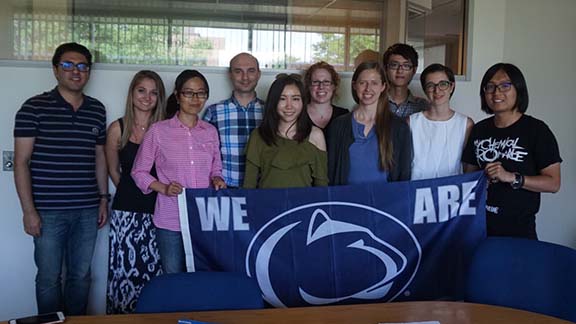 Members of the Geoinformatics and Earth Observation (GEO) Laboratory at the National Center for Atmospheric Research where they are conducting research this summer.
GOOD NEWS
For the summer, DoG news will be published every other week. Continue to send your good news, story ideas, and photos from fieldwork and travels to geography@psu.edu.
Travis Young successfully completed his comprehensive exams and defended his proposal on July 24, 2017.
William Easterling will be named an American Meteorological Society Fellow at the January 2018 Meeting.
Rob Brooks was quoted in a Christian Science Monitor article about the Clean Water Rule, also known as the “Waters of the US” rule, or WOTUS.
Guerrilla Cartography, a cartographic arts organization and creator of Food: An Atlas, has announced a Kickstarter campaign for its sister project, Water: An Atlas. A collection of more than 80 maps, Water: An Atlas is a crowdsourced atlas that portrays water trends, usage issues and global events all created by volunteer cartographers from around the world. For inquiries, please contact: Darin Jensen (djensen@guerrillacartography.org)
Weiming Hu was featured in an EMS Summer Dispatch.
Dispatch: @psugeography @GradSchoolPSU student working with @rutgersu and @AtmosNews on project with #supercomputers and weather forecasting pic.twitter.com/OmrQybcwGY
— College of EMS (@PSUEMS) July 27, 2017
NEWS
PASDA Map URLs changing
Some of the URLs at Pennsylvania Spatial Data Access (PASDA) are going to change on August 7, 2017. This only affects FTP and Map Services; the website is unchanged and is still at www.pasda.psu.edu.
PASDA is Pennsylvania’s official public access geospatial information clearinghouse. PASDA was developed in 1996 by Penn State and has served as the clearinghouse for Pennsylvania for over twenty years.
All FTP traffic should be redirected to the following new FTP URL paths:
ftp://ftp.pasda.psu.edu/pub/pasda —replaces ftp://www.pasda.psu.edu/pub/pasda)
ftp://ftp.pasda.psu.edu/pub/pasda/pamap/ — (replaces ftp://pamap.pasda.psu.edu)
Vector and raster map services have been separated onto different servers:
Vector — http://maps.pasda.psu.edu/arcgis/rest/services
Raster — http://imagery.pasda.psu.edu/arcgis/rest/services
Links to these new URLs are up-to-date on the website. If you have bookmarks, code, or MXDs that consume PASDA map services, you may need to update your local content to reflect the changes. Questions may be directed to Ryan Baxter.
NSF grant supports research into geospatial intelligence during civil rights era
During the civil rights movement, activist groups such as the Student Nonviolent Coordinating Committee (SNCC) used geography and geospatial intelligence to identify protest sites and to plan civil rights protests. A new $373,000 National Science Foundation grant is letting researchers dig into those geospatial tactics to see what can be learned about patterns of racial inequality and how the SNCC collected and leveraged geospatial intelligence data to bolster its activist efforts.
“Geospatial intelligence has become a burgeoning field in geography,” said Joshua Inwood, associate professor of geography and senior research associate in the Rock Ethics Institute at Penn State. “For us to understand this area fully, we need to consider how a range of different groups of people are engaged with the collection and understanding of geographic information and its potential to effect change. SNCC was a great collector of geography during its time.”
Farnsworth receives 2017 Michael P. Murphy Award in Geospatial Intelligence
Robert J. Farnsworth, a retired U.S. Army reconnaissance engineer and Penn State alumnus, was selected to receive the 2017 Lt. Michael P. Murphy Award in Geospatial Intelligence. He was honored during the 2017 United States Geospatial Intelligence Foundation (USGIF) Symposium in San Antonio on June 5.
Farnsworth was presented with the award by Keith J. Masback, CEO of USGIF; Nancy S. Coleman, vice president of corporate communications at DigitalGlobe; and Todd S. Bacastow, geospatial intelligence faculty member with the College of Earth and Mineral Sciences’ John A. Dutton e-Education Institute.
Researchers receive USDA grant to study new riparian buffer strategy
Rob Brooks and Riparia staff are participating in the project
A team led by researchers in Penn State’s College of Agricultural Sciences has received a nearly $500,000 grant from the U.S. Department of Agriculture to conduct a three-year study of a new flexible strategy to ramp up installation of riparian buffers.
RECENTLY/PRESENTLY PUBLISHED
Looking through a different lens: Examining the inequality-mortality association in U.S. counties using spatial panel models.
By TC Yang, SA Matthews, K Park (2017)
In Applied Geography 86, 139-151
Access: www.sciencedirect.com/science/article/pii/S0143622816306397
Two areas still need further examination in the ecological study of inequality and mortality. First, the evidence for the relationship between income inequality and mortality remains inconclusive, particularly when the analytic unit is small (e.g., county in the U.S.). Second, most previous studies are cross-sectional and are unable to address the recent diverging patterns whereby mortality has decreased and income inequality increased. This study aims to contribute to both topic areas by studying the relationship between inequality and mortality via a spatiotemporal approach that simultaneously considers the spatial structure and the temporal trends of inequality and mortality using county panel data between 1990 and 2010 for the conterminous U.S. Using both spatial panel random effect and spatial panel fixed effect models, we found that (a) income inequality was not a significant factor for mortality after taking into account the spatiotemporal structure and the most salient factors for mortality (e.g., socioeconomic status); (b) the spatial panel fixed effect model indicated that income inequality was negatively associated with mortality over the time, a relationship mirroring the diverging patterns; and (c) the significant spatial and temporal fixed effects suggested that both dimensions are critical factors in understanding the inequality-mortality relationship in the U.S. Our findings lend support to the argument that income inequality does not affect mortality and suggest that the cross-sectional findings may be a consequence of ignoring the temporal trends.
The legacy of slavery and contemporary declines in heart disease mortality in the US South
By MR Kramer, NC Black, SA Matthews, SA James (2017)
In SSM-Population Health 3, 609-617
Access: www.sciencedirect.com/science/article/pii/S2352827317300460
Nearly 50 years of declining heart disease mortality is a major public health success, but one marked by uneven progress by place and race. At the county level, progress in heart disease mortality reduction among Blacks is associated with place-based historical legacy of slavery. Effective and equitable public health prevention efforts should consider the historical context of place and the social and economic institutions that may play a role in facilitating or impeding diffusion of prevention efforts thereby producing heart healthy places and populations.