30
Oct 18

Coffee Hour with Maarten V. de Hoop | SWIG at Haunted-U | Alumnus lives his love for cartography

IMAGE OF THE WEEK

SWIG Haunted-U

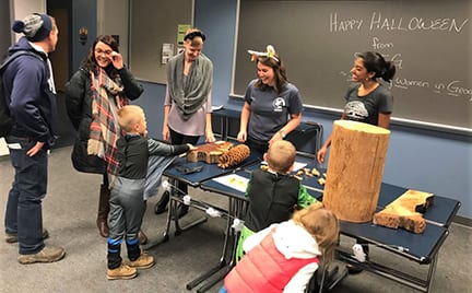
Supporting Women in Geography hosted two interactive spaces at Haunted-U. In the first one, pictured above, leaves, tree cookies, and a foliage map were used to teach kids about leaf phenology and dendrochronology. Pictured left to right: Michelle Ritchie, Stacey Olson, and Ruchi Patel. See a fun video about the event on our department homepage. Photo: Arif Masrur.

GOOD NEWS

Megan Baumann received a Fulbright-Hays Doctoral Dissertation Research Award (DDRA) to support her research in Tolima, Colombia. It’s effective from now until August 2019.

Alumna Trieste Lockwood (’08) is profiled in Style Weekly.

Chabad at Penn State is hosting two events featuring the Honorable Rachel Frier, our nation’s first Chassidic female judge. Events include a lunch program from 1:00-2:20 p.m. in Memorial Lounge of the Pasquerilla Spiritual Center, as well as a speech and Shabbat dinner at 7:30 p.m. in Chabad House, 443 East Waring Ave., State College.

A Climate Change Workshop is scheduled for Friday, Nov., 9 from noon to 3:00 p.m. in 529 Waller Building. Register here.

SWIG is hosting a Girl Scout Workshop on Sunday, Nov. 11, from 11:00 a.m.-3:30 p.m. in Whitmore Laboratory. The activity focuses on learning about geography and land cover change using Landsat imagery.

Improving Communication through Improv Theater Workshop, offered by the Office of Postdoctoral Affairs & Happy Valley Improv, Monday, Nov. 12, 1:00-2:30 p.m., in 233AB HUB. A 90-minute improv theater workshop in an energetic and supportive environment, this event will prompt participants to practice collaboration, problem solving, and responding to the unexpected. Register here.

COFFEE HOUR

Maarten V. de Hoop
Advances in computational seismology

We present new developments in large-scale computing focused on seismology, viewing Earth as an unstructured tetrahedral mesh, across an extreme range of scales. We discuss, while highlighting emerging techniques, the simulation of (i) seismic normal modes on planetary scale, (ii) high-frequency time-harmonic waves in the crust, in particular, sedimentary basins, (iii) earthquakes, and (iv) broad-band wave propagation and scattering in poro-elastic media with connections to rock physics.

  • Friday, Nov. 2
  • 3:30 p.m. Coffee and refreshments, 319 Walker Building
  • 4:00 Lecture, 112 Walker Building
  • Coffee Hour To Go Webcast
  • Next Coffee Hour is Nov. 9 with Lindsay Naylor

NEWS

Dutton Institute director advocates for all learners through Faculty Senate

Ann Taylor always wanted the experiences of being Penn State University Faculty Senate chair but knew her job duties as assistant dean for distance learning and director of the John A. Dutton e-Education Institute wouldn’t allow for the time commitment.

So the guru of nontraditional learning found a way to make it work.

Schreyer Scholar alumnus maps out dream career while seeing the world

Many of Patrick Stephens’ early interests — traveling, hiking, mountain biking — necessitated the use of maps.

Not surprisingly, then, maps themselves became one of those interests, and served as a constant reminder of how much of the world he has left to explore.

“I always liked traveling,” the Penn State Geography and Schreyer Honors College alumnus said. “I never wanted to be tied down to one place. I told myself that if I could make maps, you can make them anywhere in the world. That was always kind of the goal.”

RECENTLY PUBLISHED

Can shareholder advocacy shape energy governance? The case of the US antifracking movement

Kate J. Neville, Jackie Cook, Jennifer Baka, Karen Bakker & Erika S. Weinthal
Review of International Political Economy
DOI: 10.1080/09692290.2018.1488757
Research on socially responsible investing (SRI) and investor-led governance, especially in the climate sector, suggests that shareholders adopt social movement tactics to influence corporate governance, including building networks, engaging directly with corporations and lobbying regulators. Further, research on corporate transparency and financial disclosure has proliferated, notably in the extractives sector. Our work builds on these existing literatures, with a focus on shareholder resolutions on hydraulic fracturing (HF) in the United States. We analyze US HF-focused shareholder resolutions from 2010 to 2016 to evaluate filing strategies and outcomes. We argue that these resolutions provide space for a range of new actors to shape corporate governance—but their power is constrained. The constraints flow from the same political economy factors that enable shareholders to take collective action: the distance between individual investors and financial decisions; the structure of resolutions and managerial responses; and the complexity of investment vehicles and vote shares. We assess how shareholders respond strategically by altering the focus of resolution demands, liaising with external campaigns and networks, and engaging with government to enhance regulatory interventions. Our work reveals how the upstreaming of power in commodity chains intersects with the power of management boards and the challenges of financialization, with consequences for corporate and energy governance.

Comparison of simulated radioactive atmospheric releases to citizen science observations for the Fukushima nuclear accident

Carolynne Hultquist, Guido Cervone
Atmospheric Environment
https://doi.org/10.1016/j.atmosenv.2018.10.018
Citizen science data from the Safecast project were shown to provide a reliable estimation of the spatial distribution of concentrations of elevated radiation levels around Fukushima when compared to government data. A comparison is presented between the HYSPLIT Lagrangian atmospheric transport and dispersion (T&D) model and a reflected Gaussian model to both government and Safecast contributed measurements. The advantage of contributed data with respect to the government data is that they are collected over a long period of time and have a larger spatial coverage.

First, the Safecast contributed measurements are compared to aerial surveys completed by the Department of Energy (DOE) and the National Nuclear Security Administration (NNSA). Then the HYSPLIT T&D model is run to simulate the nuclear release using high resolution terrain and meteorological data. A Gaussian dispersion model is also run for comparison using meteorological data observed at the time of the accident. The results of both models and observed data are decay corrected to December 2016 in order to use a larger quantity of contributed measurements in the comparison.

The comparison of areas of elevated radiation shows that the citizen science observations align with the prediction of models representing dynamic behavior of radionuclides dispersed in the environment. This paper shows that citizen science data can be used to validate and potentially better calibrate atmospheric T&D models.

Industrial Maize as a Commodity System: Spatial Scale and Relations of Production in Turkey’s Agriculture After Economic Restructuring

Yetkin Borlu, Stephen A. Matthews
Journal of Economic and Social Geography
https://doi.org/10.1111/tesg.12323
During the decade of 2000‐2010, industrial maize production in Turkey doubled to approximately four million tons and the area under maize cultivation increased by ten per cent. Concomitant with the increase in total output, private agri‐food industry came to control 90 per cent of total production by 2010. Using exploratory spatial analysis and spatial regression methods, we are able to have a more detailed and spatially explicit regional study of a commodity system across Turkey. We argue that maize production in Turkey developed in the 2000s along the tenets of a corporate food regime according to demands by agri‐food firms. However, small‐scale farmers are not fully excluded from corporate relations of production, and low‐yield traditional maize farming persists in some provinces as an important field crop for household consumption.


23
Oct 18

Green Paws certification | Remote sensing and geospatial analysis faculty search | New VR course

IMAGE OF THE WEEK

ChoroPhronesis Open House

Alex Klippel shares this photo from Penn State Parents and Families Weekend Oct. 19–21, 2018. The ChoroPhronesis Lab Open House welcomed a steady stream of visitors who wanted to experience virtual reality.

GOOD NEWS

Whitney Broussard’s (’17g) MGIS capstone project was highlighted in the article, “Marshland mapping uses drone and data,” in Point of Beginnings, September, 14-19. Written by M. J. Wagner.

Chris Rothermel won third prize for his poster for the African Research Center Undergraduate Research Exhibition on Oct. 20, “The politics of Fire Ban Policies in Benishangul-Gumuz, Ethiopa.” Rothermel is a political science major; he completed a research internship with Bronwen Powell in spring 2018.

Penn State will be holding it’s fourth annual Project Management Conference at the Penn Stater Hotel and Conference Center on Nov. 7, 2018. The theme for 2018 conference is Innovation Across Disciplines: People, Processes, and Performance. The conference places focus on the interdisciplinary and collaborative nature of innovative projects, and the people and processes central to project success. Faculty, staff and students from all disciplines are encouraged to attend. For more information or to register visit: www.pmconf.psu.edu/

The Department of Geography Green Team has been recognized by the Sustainability Institute as a “Level One Certified Green Paws Office.” Team members include Cindy Brewer, Alex Klippel, Denise Kloehr, Erica Smithwick, Jodi Vender, Melissa Weaver (team leader), Jacklyn Weier, and Anthony Zhao.

COFFEE HOUR

The next Coffee Hour will be Nov. 2, 2018. The speaker will be Maarten V. de Hoop, Simons Chair in Computational and Applied Mathematics and Earth Science at Rice University.

NEWS

Assistant Professor of Remote Sensing and Geospatial Analysis

The Departments of Geography and Statistics in partnership with the Institute for CyberScience (ICS) at The Pennsylvania State University, located in University Park, PA, invite applications for a new faculty member in Remote Sensing and Geospatial Analysis at the Assistant Professor level. This tenure track faculty position is part of the cluster hire initiative of the Institute for CyberScience (ICS) to enhance big-data and big-simulation in support of the ‘Driving Digital Innovation’ thematic area of the Penn State strategic plan. ICS is a University-wide, interdisciplinary research institute with more than 20 ICS tenure-track co-hired faculty and nearly 300 associates in interdisciplinary research enabled by high performance computing (HPC).

New course puts Penn State students in control of transformational technology

In his decade of teaching at Penn State, Professor of Geography Alex Klippel has seen immersive technologies disrupt everything at the University from education to research to outreach. His belief in the power of this machinery to improve the learning process guided his creation of GEOG 197: Immersive Technologies – Transforming Society through Digital Innovation.

“I created one of the first upper-level courses on [virtual reality] and 3D modeling, and I want to share my fascination for immersive technologies with students at all levels,” Klippel said of the brand-new general education course he created alongside instructional designer Amy Kuntz. “Thanks to generous support and marvelous collaboration [with the Teaching and Learning with Technology department] we are able to advance immersive learning at Penn State and share it with a wider audience.”

RECENTLY PUBLISHED

Jack Johnson versus Jim Crow: Race, Reputation, and the Politics of Black Villainy: The Fight of the Century

Alderman, Derek H. & Inwood, Joshua & Tyner, James A.
Southeastern Geographer
doi:10.1353/sgo.2018.0027
Foundational to Jim Crow era segregation and discrimination in the United States was a “racialized reputational politics,” that constructed African Americans as not only inferior, but as villainous threats to the normative order, leading to the lynching of thousands of African Americans. While black villainy is a destructive force within society, we explore it is as basis for anti-racist politics, when appropriated by African Americans. There is a long history in African American folklore of celebrating the black outlaw who freely moves about and boldly violates moral and legal norms. Early 20th century American boxer Jack Johnson, who reigned as world heavy champion from 1908 to 1915, illustrates this complex and contested process of vilifying black bodies and reputations during the Jim Crow era. Our paper offers a critical, contextualized biographical analysis of Johnson, situating his struggles within the wider historical geography of violent US race relations and paying close attention to the controversial place he held within the white and black public imaginaries. Importantly, the African American fighter appropriated and manipulated Jim Crow villainy to challenge a white racist society and a conservative black establishment while also claiming the right to live on his own terms.

Growth and survival relationships of 71 tree species with nitrogen and sulfur deposition across the conterminous U.S.

Kevin J. Horn, R. Quinn Thomas, Christopher M. Clark, Linda H. Pardo, Mark E. Fenn, Gregory B. Lawrence, Steven S. Perakis, Erica A. H. Smithwick, Douglas Baldwin, Sabine Braun, Annika Nordin, Charles H. Perry, Jennifer N. Phelan, Paul G. Schaberg, Samuel B. St. Clair, Richard Warby, Shaun Watmough
PLoS ONE
https://doi.org/10.1371/journal.pone.0205296
Atmospheric deposition of nitrogen (N) influences forest demographics and carbon (C) uptake through multiple mechanisms that vary among tree species. Prior studies have estimated the effects of atmospheric N deposition on temperate forests by leveraging forest inventory measurements across regional gradients in deposition. However, in the United States (U.S.), these previous studies were limited in the number of species and the spatial scale of analysis, and did not include sulfur (S) deposition as a potential covariate. Here, we present a comprehensive analysis of how tree growth and survival for 71 species vary with N and S deposition across the conterminous U.S. Our analysis of 1,423,455 trees from forest plots inventoried between 2000 and 2016 reveals that the growth and/or survival of the vast majority of species in the analysis (n = 66, or 93%) were significantly affected by atmospheric deposition. Species co-occurred across the conterminous U.S. that had decreasing and increasing relationships between growth (or survival) and N deposition, with just over half of species responding negatively in either growth or survival to increased N deposition somewhere in their range (42 out of 71). Averaged across species and conterminous U.S., however, we found that an increase in deposition above current rates of N deposition would coincide with a small net increase in tree growth (1.7% per Δ kg N ha-1 yr-1), and a small net decrease in tree survival (-0.22% per Δ kg N ha-1 yr-1), with substantial regional and among-species variation. Adding S as a predictor improved the overall model performance for 70% of the species in the analysis. Our findings have potential to help inform ecosystem management and air pollution policy across the conterminous U.S., and suggest that N and S deposition have likely altered forest demographics in the U.S.

Fine‐scale spatial homogenization of microbial habitats: a multivariate index of headwater wetland complex condition

Jessica B. Moon, Denice H. Wardrop, Erica A. H. Smithwick, Kusum J. Naithani
Ecological Applications
https://doi.org/10.1002/eap.1816
With growing public awareness that wetlands are important to society, there are intensifying efforts to understand the ecological condition of those wetlands that remain, and to develop indicators of wetland condition. Indicators based on soils are not well developed and are absent in some current assessment protocols; these could be advantageous, particularly for soils, which are complex habitats for plants, invertebrates, and microbial communities. In this study, we examine whether multivariate soil indicators, correlated with microbial biomass and community composition, can be used to distinguish reference standard (i.e., high condition) headwater wetland complexes from impacted headwater wetland complexes in central Pennsylvania, USA. Our reference standard sites existed in forested landscapes, while our impacted sites were situated in multi–use landscapes and were affected by a range of land–use legacies in the 1900s. We found that current assessment protocols are likely underrepresenting sampling needs to accurately represent site mean soil properties. On average more samples were required to represent soil property means in reference standard sites compared to impacted sites. Reference standard and impacted sites also had noticeably different types of microbial habitats for the two multivariate soil indices assessed, and impacted sites were more homogenized in terms of the fine‐scale (i.e., 1‐m and 5‐m) spatial variability of these indices. Our study shows promise for the use of multivariate soil indices as indicators of wetland condition and provides insights into the sample sizes and scales at which soil sampling should occur during assessments. Future work is needed to test the generalizability of these findings across wetland types and ecoregions and establish definitive links between structural changes in microbial habitats and changes in wetland soil functioning.

An approach to estimating forest biomass change over a coniferous forest landscape based on tree-level analysis from repeated lidar surveys

Turner, S.B., Turner D.P., Gray, A.N. & Fellers, W.
International Journal of Remote Sensing
doi:10.1080/01431161.2018.1528401
Forests represent a significant opportunity for carbon sequestration, but quantifying biomass change at the landscape scale and larger remains a challenge. Here we develop an approach based on repeated tree-level analysis using high-resolution airborne lidar (around 8 pulses/m2). The study area was 53 km2 of actively managed coniferous forestland in the Coast Range Mountains in western Oregon. The study interval was 2006–2012. Tree heights and crown areas were determined from the lidar data using point cloud clustering. Biomass per tree was estimated with allometry. Tree-level data (N = 14,709) from local USDA Forest Service Forest Inventory and Analysis plots provided the basis for the allometry. Estimated biomass change over the 6-year interval averaged −1.3 kg m−2 year−1, with the average gain in undisturbed areas of 1.0 kg m−2 year−1. Full harvest occurred on 3% of the area per year. For surviving trees, the mean change in height was 0.5 m year−1 (SD = 0.3) and the mean change in biomass was 45.3 kg year−1 (SD = 6.7). The maximum bin-average increase in biomass per tree (57.3 kg year−1) was observed in trees of intermediate height (35–40 m). In addition to high spatially resolved tracking of forest biomass change, potential applications of repeated tree-level surveys include analysis of mortality. In this relatively productive forest landscape, an interval of 6 years between lidar acquisitions was adequate to resolve significant changes in tree height and area-wide biomass.


16
Oct 18

Coffee Hour with Mariana Mora | Labs open for Parents and Families Weekend | Modeling fire to restore past forests

IMAGE OF THE WEEK

LassenWinter is coming. Alan Taylor shares this image from recent field work examining the effects of the 2012 Reading Fire in Lassen Volcanic National Park. Snow fell at night on Mount Lassen and camping was in temperatures in the 20s.

GOOD NEWS

Penn State Institutes of Energy and the Environment will hold a science communication panel discussion on Wednesday, Oct. 17, at 4 p.m. in 233 HUB-Robeson Center. Attendees are asked to register: www.iee.psu.edu/2018-compass-plenary

“The Most Unknown” is an innovative documentary that attempts to reinvigorate love for scientific inquiry by exploring some of the universe’s toughest questions. Public screening of the film will be held 6 p.m. on Thursday, Oct. 18, in the Pike Auditorium, 22 Biobehavioral Health Building on the University Park campus.

SWIG will host an informal workshop with this week’s Coffee Hour speaker, Dr. Mariana Mora, on Friday, Oct. 19, from noon-1:30 p.m. in 337 Walker Building.

COFFEE HOUR

Mariana Mora
(Un)earthing cartographies, racial necro-economics and politics of absence

Four years ago, on the night of September 26, 2014 in the town of Iguala, in the state of Guerrero, Mexico, police forces, armed forces and members of organized crime violently attacked public transportation buses on which were travelling students from the teachers’ college of Ayotzinapa to take part in the October 2 commemorations of the 1968 Tlatelolco plaza student massacre in Mexico City. During the course of the night, three students were assassinated and 43 students forcibly disappeared, their whereabouts to this day unknown. The talk focuses on the case of Ayotzinapa in order to critically analyze the ways that extreme forms of physical violence and (il)legal economies engender particular expressions of racialized state formation.

  • Friday, Oct. 19
  • 3:30 p.m. Coffee and refreshments, 319 Walker Building
  • 4:00 Lecture, 112 Walker Building
  • Coffee Hour To Go Webcast

NEWS

Parents and Families Weekend at Penn State University Park Campus is October 19-21, 2018

With new large geospatial datasets from GPS, social media and online technologies, GeoSpatial analysis technologies are becoming more and more important for understanding human behavior and settlements. Come see the latest research at The GeoVISTA Center, specifically highlighting new projects from the Friendly Cities Lab, which uses data from Airbnb, Yelp, Facebook, The Yellow Pages, college admissions offices, and the NCAA to better understand how cities and communities function and how we relate to one another across geographic space.

Immersive technologies such as virtual reality are changing the way we communicate, understand the future of the planet, prepare and train ourselves, or cure phobias. ChoroPhronesis—Applied Spatial Intelligence—has developed immersive experiences for you that showcase the power of immersion across different academic disciplines. You can explore Iceland’s Thrinukagigur Volcano; experience the visions of architectural students for informal settlements in Rio, Brazil; visit the Maya City of Cahal Pech in Belize; or experience what climate change may do to a forest in Wisconsin. Many of the experiences are free for you to take home.

Geography student models future fires to restore past forests

The forests we walk through today are not the same as the ones that existed hundreds of years ago. Human activities such as agriculture, development, and logging have changed them. Fire, or really the lack of it, also changed forests, to the detriment of some species like Oaks and Pines.

Can we use fire to turn back time, bring forests closer to their original state, and maintain these ecosystems over the long term?

Previous studies show mixed results depending upon when, how often, how severe and in what season a prescribed burn was conducted. Anthony Zhao, a master’s degree student in geography, in the College of Earth and Mineral Sciences, is using computer model simulations to try to get a clearer answer to this question with his master’s research project, “Modeling Prescribed Fire Effects on Vegetation Dynamics in Pitch Pine and Mixed-Oak Forests.”

RECENTLY PUBLISHED

Acquisition and transfer of spatial knowledge during wayfinding

He, Q., McNamara, T. P., Bodenheimer, B., & Klippel, A. Journal of Experimental Psychology: Learning, Memory, and Cognition
http://dx.doi.org/10.1037/xlm0000654
In the current study, we investigated the ways in which the acquisition and transfer of spatial knowledge were affected by (a) the type of spatial relations predominately experienced during learning (routes determined by walkways vs. straight-line paths between locations); (b) environmental complexity; and (c) the availability of rotational body-based information. Participants learned the layout of a virtual shopping mall by repeatedly searching for target storefronts located in 1 of the buildings. We created 2 novel learning conditions to encourage participants to use either route knowledge (paths on walkways between buildings) or survey knowledge (straight-line distances and directions from storefront to storefront) to find the target, and measured the development of route and survey knowledge in both learning conditions. Environmental complexity was manipulated by varying the alignment of the buildings with the enclosure, and the visibility within space. Body-based information was manipulated by having participants perform the experiment in front of a computer monitor or using a head-mounted display. After navigation, participants pointed to various storefronts from a fixed position and orientation. Results showed that the frequently used spatial knowledge could be developed similarly across environments with different complexities, but the infrequently used spatial knowledge was less developed in the complex environment. Furthermore, rotational body-based information facilitated spatial learning under certain conditions. Our results suggest that path integration may play an important role in spatial knowledge transfer, both from route to survey knowledge (cognitive map construction), and from survey to route knowledge (using cognitive map to guide wayfinding).

The geography of gender inequality in international higher education

Myers, R. M. and A. Griffin
Journal of Studies in International Education
https://doi.org/10.1177/1028315318803763
The internationalization of higher education results in 4.6 million students attending colleges and universities outside their home countries. In the United States and other countries, there is significant underrepresentation of women among inbound international higher education students. Gender equality in education cannot be achieved so long as women are underrepresented in participation in this important educational venue. To better understand the drivers of gender inequalities in international higher education, this study examines the low participation rate by women coming to the United States by comparing it with participation data for women coming to the United Kingdom and Germany. Gender participation rates from both source regions and countries vary by destination country. By exploring the geography of gender inequality in international higher education, decision makers can better understand barriers to achieving international gender equality goals.

Influences of paleo-topography of the Cretaceous/Tertiary angular unconformity on uranium mineralization in the Shirley Basin, Wyoming

Covington, J. H. and P. Kennelly
The Journal of Maps
https://doi.org/10.1080/17445647.2018.1512014
The Shirley Basin is a small asymmetric synclinal structure located in northern Carbon County, Wyoming approximately 65 km (40 miles) south of Casper, Wyoming, USA. The basin formed during the Laramide orogeny of the Late Cretaceous to Early Tertiary (78–49 Ma) and contains economically significant uranium deposits. The underlying Cretaceous units form an angular unconformity with the overlying Tertiary units that represents a paleotopographic erosional surface characterized by stream channels and overbank deposits of interbedded sand and clay with some organic detritus. Furthermore, the Cretaceous shales function as the lower confining unit/aquitard for in-situ recovery (ISR) uranium mining, and the overlying Tertiary sandstones host the uranium mineralization.

This study maps the K/T boundary in greater detail than previous studies and identifies paleotopographic features that influence sedimentary environments and structures that favor uranium mineralization. Using a larger study region and thousands of historical wells and associated electric logs not available to previous studies, this research identifies unit boundaries and enters them into Golden Software’s Surfer and Esri’s ArcGIS to construct a detailed structure contour map on the K/T surface. The map delineates paleotopography such as hills and river channels, with the latter showing a strong spatial association with uranium mineralization. Geologists can use these maps to identify thicker host sands and fluvial features which enhance uranium mineralization. Mining companies can reduce operational and exploration costs by drilling in these more favorable areas to efficiently delineate the ore body geometry and develop more accurate mine unit designs that will maximize uranium recovery.


09
Oct 18

GIScience faculty position | SWIG essay contest | Peirce Lewis event

IMAGE OF THE WEEK

faculty remember Peirce Lewis

Remembering Peirce Lewis

The Department of Geography honored the late Peirce Lewis on Friday, Oct. 5 with a special Coffee Hour lecture given by his advisee Richard Schein (’83g) now professor of geography at the University of Kentucky. Pictured above, Lewis’s contemporaries (left to right: Ben Marsh, Joe Wood, Jim Eisenstein, and Ron Abler) share their memories at a special reception for family, friends, colleagues and students held in the Joel M. Myers Weather Center.

GOOD NEWS

Fritz Kessler is serving as president of The North American Cartographic Information Society (NACIS) this year.

Alexander Klippel is giving the Geosciences Colloquium talk on October 23. The talk is at 4:00 p.m. in 22 Deike Building.

Bike Safety Workshop: Penn State students, faculty and staff, as well as local community members (ages 18 and older) are encouraged to attend a free bike safety workshop on Thursday, Oct. 18 from 3 p.m. to 5 p.m. at 117 Weston Community Center at Penn State’s White Course Apartments. For more information or to RSVP for the event, please visit www.biking.psu.edu. Spaces are limited and RSVPs must be received by end of day Wednesday, Oct. 17. This workshop is sponsored by Penn State Transportation Services.

Esri Mid-Atlantic User Conference: Esri has changed the dates of the this year’s Esri Mid-Atlantic User Conference to avoid any conflicts with Election Day. The conference will now be held on November 28–29, 2018 at the Hilton Meadowlands, East Rutherford, NJ. The agenda, registration link, and exhibitor registration are posted at www.esri.com/en-us/about/events/esri-mid-atlantic-uc/overview.

COFFEE HOUR

Next Coffee Hour is October 19. The speaker will be Mariana Mora, associate professor-researcher at the Center for Research and Advanced Studies in Social Anthropology (CIESAS) in Mexico City. Her talk is titled, “(Un)earthing cartographies, racial necro-economics and politics of absence.” For more information, visit: www.geog.psu.edu/event/coffee-hour-mariana-mora

NEWS

Tenure-Track Faculty Position in GIScience (Assistant Professor)

The Department of Geography at The Pennsylvania State University, University Park invites applications for a tenure-track faculty position at the rank of Assistant Professor specializing in geographic information science (GIScience). We are interested in candidates who will strengthen the department’s research and teaching program and help build strong connections to other relevant science communities. Candidates with an emphasis in any area associated with GIScience will be considered. A PhD degree completed before August 1, 2019, is expected. Excellence in teaching, research, and service is expected of professors employed by Penn State Geography, as is development of an externally funded research program. Participation in the department`s online geospatial education programs is also expected.

SWIG Essay Contest call for submissions

The Jennifer Fluri and Amy Trauger 2019 Student Essay and Creative Works Competition is now open! This is the fifth annual competition run by Penn State’s SWIG. We invite undergraduate and graduate students from all institutions and disciplines to contribute using any of a variety of potential formats. Submissions are due March 23, 2019. Visit for more information and to submit your work, visit: sites.psu.edu/swig/the-jennifer-fluri-and-amy-trauger-student-essay-and-creative-works-competition/

Recognizing the role of gender, class, sexuality, and race in the organization of our everyday lives, Supporting Women in Geography (SWIG) aims to promote and empower women and other underrepresented groups by offering a supportive network that sponsors opportunities to grow professionally, intellectually, and personally within the discipline of geography. Dr. Jennifer Fluri and Dr. Amy Trauger were instrumental in the establishment and promotion of Penn State’s SWIG organization. Their defining leadership established a long-standing culture of mentorship, support, and outreach. By hosting this award in their names, we hope to honor the spirit of their work.


01
Oct 18

Coffee Hour with Richard Schein in memory of Peirce Lewis

IMAGE OF THE WEEK

Nature-Society Panel

The Department of Geography hosted the eighth Nature-Society Workshop on September 21–22 with Syracuse, Rutgers, Clark, Cornell, West Virginia, and Temple universities. Pictured above, Panel 1, moderated by Jenn Baka, explored land and resource geographies.

GOOD NEWS

Megan Baumann has received a position as a visiting student with a research internship at the Universidad National de Colombia, sede Bogotá (National University of Colombia at Bogotá) within the College of Agricultural Sciences, working with Dr. Álvaro Acevedo Osorio, agronomist and agroecologist. The UNAL is known as the country’s premier public university. Baumann will be there until early August 2019.

On October 4, Dr. Christina Hupy, Director of Education and Training at Boundless Geospatial (https://boundlessgeo.com), will give a presentation at noon EST. Students may participate in person at 413 Earth and Environmental Systems Building or online. The online zoom room is https://psu.zoom.us/j/812983558.

On October 9, Lise Nelson will give a talk on “Affluence and the Production of Illegality,” sponsored by the Humanities Institute. The talk is at noon in 124 Sparks Building. (Light lunch served at 11:45 a.m.)

COFFEE HOUR

Richard Schein
Aphorisms for Reading the Landscape: Lecture in Memory of Peirce Lewis

Peirce Lewis published “Axioms for Reading the Landscape” in 1979, in a small but important volume titled The Interpretation of Ordinary Landscapes (D.W. Meinig, ed.). Lewis remarked in that essay that (f)or most Americans, cultural landscape just is, before he suggested to the contrary that all human landscape has cultural meaning. This talk posits Lewis’s “Axioms” and the Meinig volume as a watershed moment for U.S. landscape study. It moves from a brief genealogy of the landscape idea in Geography to focus on the post-empiricist landscape imperative that takes seriously Lewis’s claim by asking what is it that landscapes do. What landscapes might do will be presented through a set of aphorisms—concise statements that try to capture important critical-theoretical engagements with the idea of landscape. Some of those aphorisms for reading the landscape will be presented through case studies and examples in what Lewis so famously called the tangible, visible scene.

  • 3:30 Coffee and refreshments, 319 Walker Building
  • 4:00 Lecture, 112 Walker Building
  • Coffee Hour To Go Webcast
  • 5:00 Reception in the Joel M. Myers Weather Center (sixth floor, Walker Building) with hors d’oeuvres and wine/beer and time for people to share their stories and memories

NEWS

‘Women in Geospatial Sciences, Building Leaders for Tomorrow’ workshop

Penn State and Syracuse University will host two 1-and-a-half-day workshops to identify challenges women currently face in U.S. universities, and provide recommendations to retain women leaders in the geospatial sciences, through active engagement and building of peer-mentorship networks within departments, and also across the university and between universities.

RECENTLY PUBLISHED

Urban National Politics in the United States (book chapter)

Joshua F. J. Inwood
The City as Power: Urban Space, Place, and National Identity edited by Alexander C. Diener, Joshua Hagen
http://a.co/d/7igtMmZ

Does Effectiveness of Weight Management Programs Depend on the Food Environment?

Tarlov, E. , Wing, C. , Gordon, H. S., Matthews, S. A., Jones, K. K., Powell, L. M. and Zenk, S. N.
Health Services Research
doi:10.1111/1475-6773.13043
To estimate the causal effects of a population‐scale behavioral weight management program and to determine whether the program’s effectiveness depends on participants’ geographic access to places to purchase healthy and less healthy foods. Secondary data from U.S. Department of Veterans Affairs clinical and administrative records (2008–2014), retail food environment measures from commercial databases (2008–2014), and the American Community Survey (2009–2014). We estimated the effect of the VA’s MOVE! weight management program on body mass index after 6 months using difference‐in‐difference regressions to compare participants with a propensity score‐matched control group. We estimated treatment effects overall and in subgroups with different access to supermarkets, fast‐food restaurants, and convenience stores. MOVE! reduced BMI by about 0.71 units among men and 0.70 units among women. The program was slightly less effective for men living near fast‐food restaurants or convenience stores. We found no evidence that treatment effects varied with the food environment among women. The residential food environment modestly alters MOVE! effectiveness among men. A greater understanding of environmental barriers to and facilitators of intentional weight loss is needed. This study highlights important potential intersections between health care and the community.


Skip to toolbar