This post was written by Paige Andrew, Maps Cataloging Librarian.

A portion of sheet 1 of the 1906 Sanborn map of State College, Pennsylvania. Note the added textual information such as population of 1000 included in the title frame.
For nearly a century and a half the maps that comprise a historic Pennsylvania collection in the Libraries, published by the Sanborn Map Company (and earlier iterations of the name), have long provided a unique, graphic, primary resource for a variety of research needs. Sanborn fire insurance maps have tracked the growth of cities and towns in the United States over time and provide an abundance of information on each community represented.
Genealogists, architects, urban planners, historians and others have long prized them for their impressive detail, multiple editions that update changes, and distinctive style. Whether tracing turn-of-the-century city expansion, looking for the home of an ancestor, or researching boundaries and zoning ordinances, Sanborn maps are a key source of reliable data. In addition, most individual communities comprise multiple editions, each edition being a specific date that provides a unique perspective on a community’s growth, and sometimes decline, over time.
Surveyor D.A. Sanborn founded the company in New York City in 1867 to create special maps, most often at a scale of 1:600, or 50 feet to the inch, to aid companies in assessing liability for fire insurance coverage of buildings. Teams of surveyors infused the maps with a remarkable level of detail, providing a fascinating snapshot into community and industrial growth. The map sheets that cover each community accurately show the location of buildings and outbuildings, including details such as where windows and doors are positioned, as well as property boundaries, the names of land and company owners, the width of streets and sidewalks, building use and, most importantly, the material types used for homes, businesses, and other building construction. Key local industries were sometimes highlighted with inset maps, and textual notes add useful information such as the type of water supply and firefighting equipment available. Other useful tidbits of information found on these maps include population figures, street and building indexes, and even prevailing winds!
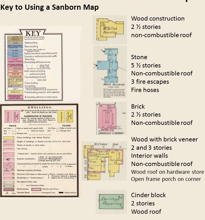
This image shows the color-coding scheme created to show the different building material types used in constructing a house or business, as well as other critical fire insurance-related information.
The University Libraries holds perhaps the largest collection of Sanborn maps in the state and certainly one of the largest in the United States. While the vast majority of our collection of Pennsylvania Sanborn’s consists of individual unbound sheets, maps for some of the more industrialized areas and largest urban areas were published as bound volumes. No matter the physical form, the entire collection is housed together in the Donald W. Hamer Maps Library, located in the basement of Central Pattee Library, and is available for use only by appointment with Maps Library staff. A description of the collection, an alphabetical-by-community-name index and more is located at http://www.libraries.psu.edu/psul/digital/sanborn.html.
One need not step into the Maps Library however to view much of the collection. In 2013 members of the Libraries’ Maps Cataloging Team and the Digitization and Preservation Department completed a three-year major project to catalog and digitize (scan) the entire collection. It spans the late 19th and early 20th centuries, and contains 31,036 sheets representing 585 communities across the Commonwealth. Titles published before 1923, and others determined to no longer be under copyright are available online. To view digital map images click on a community name in the alphabetical index noted above. Alternately, one may use an online interactive index map of Pennsylvania to discover which Pennsylvania cities and towns are a part of the collection.
These historic maps can also be discovered by using The CAT, the Libraries’ online catalog, by conducting a keyword search on the word “Sanborn” plus the desired community name, and then limiting the search to the “Maps Library” location. Scanned copies of individual non-copyrighted sheets may also be obtained with the assistance of the Maps Library staff. A complete research guide for Sanborn and other fire insurance maps is available online. For more information, contact the Maps Library at 814-863-0094.