Tag Archives: geography

The Kingdom of Kush

Looking back into the history of Sudan and it’s great people, one can’t truly appreciate the realm and privileges of the country’s being and existence without comprehending it’s establishments and rises.. The name of the country alone represents it’s beings who inhabited the land.

Unknown-1“Sudan” translated to the Arabic meaning of land of the black people. By the 6th century, the country was Christianized, then with existence dating back to c. 650, Islamization of the land arose between the eight and nineteenth century. During this time, men lived in political unity among the four-thousand mile “Valley of the Nile.” Prehistorically speaking, many evolutions of the land began extraordinarily before such era.

The Neolithic people first inhibited the land and survived on prehistoric materials. Living in villages of huts composed of mud and brick, conditions were less luxurious than expected. Food resulted from anything collected during hunting or fishing along the river. Grain was collected and agriculture rose for the people of the Nile river valley.

imagesTrade was a large aspect of the developing years of Sudan. The Egyptians would compose deals of agriculture material, such as grains, with the land of Kush for stones, incense, etc. When Egyptians began seeking a more permanent trading area, they decided for travel forts protecting the trade of gold, which was very valued to the mines in Wawat. Gold and slave trades were amongst the pharaoh’s control.

Mansa_MusaEgypt then felt more power over the area and pharaoh Ahmose arose the New Kingdom from c. 1570-1100 BC. During which time the extent of control contained Kush until the fourth cataract. The Egyptian soldiers expected devotion is exchange for respect and commitment from chiefs and kids over the pharaoh’s people.

A language was established within the community which was used in all aspects of work, socializing, and living for the people once settled into the area. The temples of hard work and time were used for the religious worship of Christianity until diminishing after the 6th century.

Although generic information concerning the history and evolution of Sudan exist amongst the Internet in scatters, there isn’t much online or physical history to the land. I strongly believe because the history of Egypt and the Nile is so widely known and recognized, the country sitting on the other side isn’t taken into consideration or mentioned. The history was never a violent once, aside from the assumed slavery and pharaoh ruling that existed in a majority of the surrounding countries at such time. I believe although somewhat generic and peaceful, the land of Sudan be more recognized for it’s beauty and graciousness to surrounding countries and rise than be left in the dust as such.

South Sudan: history and how old it is

Blog Assignment 3 – Ancient History


The New York Times in Africa from the world section was mainly treating about African culture regarding to the geography and other factors, and there were many online sources by the journal that the other authors or reporters from African society have written. Generally most of the online sources had sufficient information to track the history of Sudan. All the sources from the New York Times and geography related sites such as geography.about.com and so on.

South Sudan, officially called the Republic of South Sudan, is the world’s newest country. It is a landlocked country located on the continent of Africa to the south of the country of Sudan. South Sudan became an independent nation at midnight on July 9, 2011 after a January 2011 referendum regarding its secession from Sudan passed with around 99% of voters in favor of the split. South Sudan mainly voted to secede from Sudan because of cultural and religious differences and a decades-long civil war.

Three ancient Kushite kingdoms existed consecutively in northern Sudan. This region was also known as Nubia and Meroe, and these civilizations flourished mainly along the Nile River from the first to the sixth cataracts. The kingdoms were influenced by, and in turn influenced Pharaonic Egypt. Dynasty was founded under Alara and regained independence for the kingdom of Kush although borders fluctuated greatly. I was overwhelmed by the fact that Sudan is the only country in sub-Saharan Africa that has real archaeology and local teams working.

Though its historical importance has long been overshadowed by Egypt, its neighbor to the north, Sudan’s archaeological record is pivotal to understanding the history of Africa itself, experts say, and a wave of new discoveries may be adding crucial new information. “The history of Sudan can play a role for Africa that Greece played for the history of Europe,” Mr. Rilly said enthusiastically. “People have been living here for 5,000 years” along the Nile, he added. “It is difficult not to find something.” The Egyptians conquered Sudan in 1874 and established the province of Equatoria. Islamic revolutionaries entered the territory in 1885, but British troops defeated the invaders and took over Sudan in 1898. Britain and Egypt ruled the country, and in the early 20th century, Christian missionaries converted a large segment of the population and introduced English to the region. This result was a clearly defined line between the Arab north and the black African animists and Christians in the south. South Sudan depends largely on imports of goods, services, and capital from the north. South Sudan does have abundant natural resources and produces nearly three fourths of the former Sudan’s total oil output of nearly a half million barrels per day.

The government of south Sudan derives nearly about 98% of its budget revenues from oil. As people might know well about the significance of oil, oil is exported through two pipelines that run to refineries and shipping facilities at Port Sudan on the Red Sea. However, on July 2011, South Sudan became an independent country. South Sudan seceded from the Republic of Sudan in 2011. Geographically it is not the part of the Sudan region forming as it does part of Sub-Saharan Africa. It is the parts of the East Sudanian Savanna.

Like a Diamond In the Sky!

flagsierraEverOLYMPUS DIGITAL CAMERA 
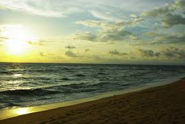
wonder where those pretty little diamonds on television commercials and celebrity ring fingers come from? I know I have! The fact is that it is extremely likely this beautiful rock comes from mines in Sierra Leone. Sierra Leone is a small beautiful country with a lot of history located right on the cost of West Africa. With warm untouched beaches on Bonthe Island or Sherborough Island right off its coast, there is no place else you’d want to be! Do you love animals? Come to Sierra Leone and visit the Gola Forest National Park and see the wide selection of species! The Gola Forest National Park is home to animals such as the endangered West African elephant, the western chimpanzee and many bird species. And for those looking to enhance your Middle Eastern experience, how about hiking the highest peak in West Africa? Mount Bintumani and the Loma Mountains is home to the Lowland Western chimpanzee and is filled with ancient history! Many of you are probably interested in the culture of Sierra Leone. Not a problem! The best way to experience the culture of Sierra Leone is by visiting one of its villages. Tourists love the small village of Rogbonko and so will you. Come get immersed in the Sierra Leonean culture and enjoy an experience of a lifetime! I can’t stress what an important figure in the world’s history this small country holds. Sierra Leone was home to many slave trade transactions between the western and eastern worlds. Just a boat trip from Sierra Leone to Bunce Island, be a witness to one the world’s first stations of this nonsensical practice that occurred in the 18th and 19th centuries. Do you just want to relax and enjoy the sun? Why not visit Sulima a beach town located right of the Liberian coast near Sierra Leone! Enjoy the popular Liberian ‘Club Beer’ while taking a swim in the ocean. Recently speaking of diamonds, Sulima is home to one of the world’s oldest mining companies! Another park tourists can enjoy is located in the northern part of the country. Outamba-Kilimi National Park is home to animals such as elephants, chimpanzees and even pigmy hippos! HIPPOWant an entirely breathtaking beach all to yourself? Then a visit to Sierra Leone’s very own Freetown Peninsula is a must! On a sunny day on this peninsula you’ll uncover the reasoning behind the colors on the Sierra Leonean flag. Once you have enjoyed a relaxing day at the beach, learn a little more about the peninsula at the Freetown museum and take a peak its most famous attraction a 500-year old cotton tree! Enjoy another of the numerous beaches of Sierra Leone, a big one called Lakka Beach. If you love fishing one of the largest fishing grounds is located in Sierra Leone! Come enjoy a nice day at sea and forget your worries! If you’re looking for an adventure, look no further! Sierra Leone’s variety in attractions, museums, beaches, mountains and wild life will  take you on the adventure of a lifetime! Hope to see you soon on this side of the ocean!

The Artwork of Angola

Angola can only be described as a land of Divinity, in light of all of its complexities. It is a melting pot of differing landscapes that allows its visitors to experience many worlds in a single country.  In Angola, there lies rainforest in the north, montainous forests in the highlands, and grasslands across plateau areas in the south. This landscape that makes up the country of Angola is twice the size of France and Great Britain, allotting an expansive landscape for the artwork that is Angola.

angola

The country is located in the western region of Southern Africa and is made up of a part of the largest river in West Africa, the Zaire or Congo, which measures at 4,000 kilometers. The country is also comprised of a part of the largest river in East Africa, the Zambeze, which measures at 2,680 kilometers. Bording countries include: the Democratic Republic of Congo in the north, Zambia in the East, Namibia in the South, and by the Atlantic Ocean in the West.

As numerous bodies of water surround the country, Angola is also home to many exotic animal species. Animals include: elephants, giraffes, zebras, wildebeests, antelopes, lions, leopards and hyenas. Ultimately, it is an ideal destination for travelers seeking to experience the diverse wildlife that Africa has to offer. The country is also known for an abundance of dolphins, including the rare “humpback dolphin”.

The weather in Angola is determined by two seasons, which are the rainy season and the dry season (also known ascacimbo). The rainy season, which is normally accompanied by elevated temperatures creating a tropical environment, usually occurs from August to May. Rainfall and annual variation of temperatures are two climatic characteristics common to Angola. These characteristics are created by the country’s geographical makeup. It is placed in both the intertropical, and subtropical zones of Africa, and also lies in close proximity to the sea. Additionally, the cold current of Benguela affects the country’s weather conditions.

Weather conditions in Angola are not in the least bit troublesome, however, as the country is highly conducive to agriculture. The most fertile soils are by surrounding waters, where there are extensive pastures and tropical forests. These tropical forests include rare species of trees including: ebony, sandalwood, rosewood, eucalyptus, and pines. In agriculture, the country is known for having adequate success in growing cotton, coffee, sisal, peanut, sweet potato, beans, sugar, rubber, corn, greens, fruits, etc. The country is also known for maintaining cattle, goats, sheep and pigs, and is known for being the single-most popular country in regards to the fishing industry. The Angolan coastline is one of the richest in fish on the continent and until recently, was the number one producer of fish for consumption.

For an overall, diverse cultural and enlightening experience, Angola is an ideal destination. Its expansive and diverse landscape provides a veritable plethora of animals, foliage, foods, and much more. One trip to Angola may even substitute several trips to many other countries that may not be quite as diversified.

Botswana Your Next Destination

Beauty and adventure awaits you in Botswana, your next destination. Home to one of the world’s largest inland deltas, and diverse wildlife, Botswana offers some of the world’s finest geological features. From its prominent flat lands that lead to rolling high plains, to its vast dessert, and exciting savannas; Botswana has the adventure you seek.

botswana1
Botswana is a landlocked country located in the center of Southern Africa covering 582,000 sq. km2 . It is about 900 meters above sea level and relatively flat aside from its hills and deep valleys located at the eastern part of Botswana. About 70 % of Botswana is occupied by the magnificent Kalahari Desert. One of the longest rivers the Okavango that runs through South Africa, flows into the north-western part of the country, forming the world renowned Okavango Delta. The Okavango delta is a must see sight that can be taken in by the mokoro a traditional dugout canoe through a thrilling and captivating watery maze. As you drift by in the mokoro canoe you will marvel at the hypnotic view of reed beds, exotic birds, reptiles and amphibians. botswana3For the more adventurous folks, there is the option to travel through the papyrus swamps with a motorboat which is a louder and more interactive alternative. With this option tourist have the option to interact with bigger animals such as elephants, hippos and buffalo. The dryer safaris offer game such as lions, hyenas, leopard’s cheetahs and wilddog. Tourist also have opportunities to play interact with the loveable meerkats and make new friends.


botswana2

Aside from its beautiful water and land safari’s, Botswana’s Kalahari desert and  Makgadikgadi Pan, a large salt pan that lies in the north a must see sights. The Kalaharia desert is a semi-arid desert that occupies a large part of Botswana spanning about 900,000 sq. kilometers. This desert is part desert and plateau which supports some animal and plant life. The small amounts of rainfall received are what help support these life forms. One site that will truly not disappoint is the  Makgadikgadi salt pan, north of Botswana. It is one of the largest flats in the world. The Makgadikgadi Pan covers 10,000 sq. km of the Kalahari. Enormous and various sized salt cover the land surrounded by grassland and scenic palm-tree islands.

botswana4 kalahari-deserts


If you are looking for a beautiful engaging and exciting place for your next destination Botswana is the place for you. You will not be disappointed with the picturesque landscape of Botswana. Enjoy amazing hypnotizing and exciting safaris, savannas and grasslands. Enjoy our diverse fauna and the beauty of Mother Nature at Botswana your next destination. Take the steep and make your way down to the Beautiful Botswana.

http://www.africatravelresource.com/africa/botswana/guide/

http://www.globalgrasshopper.com/travel/10-beautiful-places-visit-botswana/


Naijiria ni fun wa gbogbo (Nigeria is for us all)

When you hear of Africa what do you think? let me guess; naked people everywhere, lions, elephants and monkeys roaming the streets. This is probably what a majority of people think of Africa. Allow me to introduce you to a side of this beautiful continent you’ve never seen, Welcome to NIGERIA!

Nigeria

The capital of Nigeria is Abuja. The official language in Nigeria is English, but there are three main languages of this country. They are Yoruba, Hausa and Igbo. There are many different cultures, beliefs and history among the people of Nigeria.

If you are interested in history, there are many historical sites in Nigeria such as the Freedom Park which is located in Lagos Island, Lagos. The Park is a memorial which was designed to honor and preserve the heritage and history of Old Board Street prison which was used by the British colonial masters to punish and imprison individuals that opposed colonial rule such as Chief Obafemi Awolowo.

Nigeria has a rich music history! Global artists like Fela Kuti paved the way for music in Nigeria to flourish, which now has a multitude of music superstars known all over the world! Some of the modern musicians in Nigeria include artists such as D’Banji who signed with Kanye West’s label “Good Music.” Other artists include P-Square with hits like “Onyinye” ft American superstar Rick Ross! There is a traditional melody fused with modern westernized hip-hop, so you can get “JIGGY WITH IT!”

Do you like to eat? There are also various types of food from different ethnic groups. To name a few, there is fried rice which is a delicious dish comprised of rice, cow liver, carrots and seasonings which is served with salad, chicken, beef or fish. There is also pounded yam with vegetable soup which is boiled yam placed in a traditional mixing tool. Jollof rice which is rice mixed with various types of spices, tomato onions and seafood. There is also fufu with okra, and pate which is dry corn. All which are served with an ice cold traditional beverage like Vita Malt.

If you are interested in wildlife, there are many National Parks in Nigeria such as Kamuku National Park which is the most popular park in Nigeria settled on 1121 square km. Various wildlife from antelopes, elephants and, hyenas roam the area. Besides wildlife, there are nature reserves, such as Matsirga Waterfalls which is located in Madakiya. This one area has four waterfalls falling at 30 meters. The waterfall not only provides a scenic view, but it also creates a relaxing and serenity feel with its often rainbow-colored mist. This is just one of many nature reserves.

elephants

The weather in Nigeria is tropical usually around 88 degrees Fahrenheit which means you and your family will have ample time to enjoy beautiful beaches and eat coconuts and mangoes on the sand. The most popular beach visited by tourists is the Coconut beach, which is located in Badagry town in the western side of Lagos. As the name states, the beach is FULL of coconut trees, which provides shade and a relaxing environment. Other options include the Central Beach, Tarwa Bay and Calabar Beach.

COME TO NIGERIA!

Liberia Is Where You Want To Go!

Are you looking to explore another part of the world on your next vacation? How about Liberia in Western Africa! Liberia is a beautiful country filled with rich heritage and indescribable scenery. If you’re looking to explore yet not get too far outside of your comfort zone, the official language of Liberia is English meaning you can get an adventurous experience without having to fumble with dictionaries and translation books. Now that I’ve sold you on the familiar and relatable possibilities that await you in Liberia, lets take a look at what this luscious country has to offer!

Liberia borders the North Atlantic Ocean meaning that not only will you have the opportunity to take in beautiful sunsets, sandy shores and brilliant beaches on a regular basis, you might also be tempted to explore the habitats of natural oceanic wildlife! Since a lot of Liberia borders this ocean, it leads to some very pleasant and unique climate characteristics. On average, there is a very tropical atmosphere that exists in Liberia with the air being humid and hot. If you happen to spend your time on the coast, this heat will be much more bearable due to a constant breeze blowing from the ocean making life very enjoyable. The mild winters that consist of warm days and cool nights are a nice change of pace from the common snowy and fridge winter season that can be experienced in many parts of the United States. During the summer months, you’ll have the opportunity to experience a wet and tropical summer with cloudy skies and at times frequent and exhilarating rainfall. The average temperature is between 81 and 68 degrees Fahrenheit, which is about as perfect weather as you will get on a relaxing vacation anywhere!

Screen Shot 2014-09-10 at 10.56.32 PM

Screen Shot 2014-09-10 at 10.57.30 PM

Next stop on the virtual tour of Liberia is the gorgeous landscape; one that is hard to be rivaled! Liberia is mostly flat, wet, land with the occasional rolling hills and mountains that provide small outlooks over the country. If you have the opportunity, hiking through this unique terrain is sure to be a treat for the whole family or a single traveler looking to explore these different types of land all in one place. What really makes Liberia unique is the fact that most of its flat land or “lowland” is rare to the rest of Africa. Much of the rest of the continent raises a lot further above sea level. If you’re looking for a more structured view of what Liberia has to offer through its vast terrain and wildlife, numerous national parks exist in which you have the ability to experience this tropical land on your own time and on the parts that interest you most.

If this hasn’t made you want to buy the first plane ticket to Liberia, I don’t know what will! From rolling, breezy beaches to flat tropical terrain to low rise mountains, Liberia has a wide range of adventurous destinations that make the other side of the world seem a lot more diverse and exquisite than ever thought before. It might be time to let this magnificent country and all it has to offer, speak for itself.

Screen Shot 2014-09-10 at 11.22.18 PM

Screen Shot 2014-09-10 at 11.22.45 PM

Images: Google Images

https://www.courses.psu.edu/test/test100_hkr/AFIM/Main_HTML/RG_W_LIB2.html

http://geography.about.com/library/cia/blcliberia.htm

http://www.nationsencyclopedia.com/Africa/Liberia-CLIMATE.html

Hey let’s take a Vacation to South Africa!

To a nation that has a great history and tradition we explore one continent if not the world’s most beautiful countries South Africa. I would like to inform you about South Africa’s geology, topography, rivers, lakes, and mountains. The land mass of South Africa is very old and particularly rich in mineral resources.

The Mountain socle in South Africa was already part of the supercontinent Gondwanaland which, 300 to 100 million years ago broke into many parts that built whole new continents, Africa being one of the nations included. Through the following, millions of years lasting geological shifts, tectonic arching, breaking and the formation of crevasses, the resulting outbreak of volcanoes, depressions, the deposition of gravel and wind and water erosion the geological profile of the land has formed. Since South Africa is located in the west, south, and east surrounded by single mountain ranges is known as the Great Escarpment. In front of the escarpment, there is a partially very narrow coastal strip, which is called the Lowveld. At the Indian Ocean, these coastal plains have high precipitations and are fertile. The western part, however, is, due to the cold Benguela current of the Atlantic, a coastal desert, reaching up to Namibia and Angola. When one crosses the escarpment they come across to central high plateau called the Highveld. The reason why the surrounding mountain chain forms a catchment area for the clouds from the sea, the precipitation on the Highveld is low which can result in arid, semi-desert conditions.

South Africa’s topography has a mean altitude of about 1,200 m (3,900 ft), and at least 40% of the surface is at a higher elevation. Parts of Johannesburg are more than 1,800 m (6,000 ft) above sea level. There are three major zones: the marginal regions, which range in width from 80 to 240 km (50–150 mi) in the east to 60–80 km (35–50 mi) in the west, and including the eastern plateau slopes, Cape folded belt, and western plateau slopes; a vast saucershaped interior plateau, separated from the marginal zone by the Great Escarpment; and the Kalahari Basin, only the southern part of which projects into north-central South Africa.

In South Africa there are only two major rivers in South Africa the Limpopo, a stretch of which is shared with Zimbabwe; and the Orange with its tributary, the Vaal, which runs with a variable flow across the central landscape from east to west, emptying into the Atlantic Ocean at the Namibian border. There are several small rivers run into the sea along the coastline, but none of them are navigable and none provide useful natural harbors. The coastline itself, being fairly smooth, provides only one good natural harbor, at Saldanha Bay north of Cape Town. A lack of fresh water in this country prevented major development here.

South Africa is home to the world’s largest natural lakes and human constructed lakes. Southern Africa’s natural lakes have very diverse origins. Those along the East African Rift Valley  also known as Lakes Malawi, Albert, Tanganyika and Turkana are deep tectonic lakes; some lakes were formed by volcanic action, such as Lake Kivu in Rwanda/Democratic Republic of the Congo. There are also shallow floodplain lakes such as those in the Okavango Swamps. There are deflation basins or pans such as those found in the Kalahari and Panlands of South Africa. Africa’s lakes support important fisheries that sustain millions of livelihoods and contribute to food security.

While exploring the rest of the country you come across South Africa’s Mountain Ranges. These mountain ranges of South Africa are some of the oldest and most beautiful in the world. They include Cape Town’s Table Mountain and KwaZulu-Natal’s uKhahlamba-Drakensberg ranges, plus other wonders like the ancient Magaliesberg and the majestic Cederberg range. The uKhahlamba-Drakensberg is South Africa’s highest mountain range which goes up to 3,000m and spans more than 150km.

As we come to end to our South African tour. This glorious country has so much rich pride to not to be wasted. Come to a country which welcomes newcomers to explore special features we have unlike many countries before us. I learned so much traits about this country that i didn’t know before and if i was anyone who loves adventure South Africa is a place to discover.

South Africa People


Visit Cameroon!

Cameroon is located in Central Africa, neighboring Nigeria, Chad, Central African Republic, Gabon, and Equatorial Guinea. It is 475, 442 square kilometers. Its coastline lies on part of the Gulf of Guinea and the Atlantic Ocean. The largest cities are Douala and Yaoundé. Cameroon is home to approximately 22.25 million people. The official languages are English and French, however there are hundreds of dialect spoken throughout the country. Cameroon is composed of more than 250 ethnic groups which are grouped into five major geographic divisions. The divisions are based on the dominant physical, climatic, and vegetative assets. There are also a number of traditions, beliefs, practices, and religions present.

Geographically, Cameroon is just as diverse; ranging from coastal plains in the southwest, to dissected plateau in the center, to mountainous in the west, to flat plains in the north. The climate throughout the country is humid subtropical. The natural features in Cameroon include beaches, deserts, mountains, rainforests, and savannas. The coastal plains spans 15 to 50 kilometers inward from the Gulf of Guinea and has an average elevation of about 90 meters. The coastal plains tend to have a hot, humid yet short dry season, to complement its dense and wet forests.

The chain of mountains, hills, and plateaus, known as the Cameroon range, extends from Mount Cameroon on the coast to almost Lake Chad, at the northern border. Mount Cameroon is Cameroon’s highest point, which stands 4,040 meters high. Mount Cameroon is a volcano, which was last active on August 21, 1986. The Cameroon range has a more mild climate and high rainfall. The soil in this region is among the most fertile in the country, especially surrounding Mount Cameroon. The southern plateau rises north into the grassy Adamawa Plateau. This region expands from the western mountainous area and forms a borders between the north and south areas of the country. The average elevation for this region is about 1,100 kilometers and its average temperature is about 23 degrees Celsius with heavy rainfall between April and October peaking in July and August. The northward lowland region spans from the edge of the Adamawa to Lake Chad, with an average elevation of 325 meters. Its primary vegetation is savanna scrub and grass. This area is arid with sporadic rainfall and high median temperatures. The diversity in terrain and climate promotes varied agricultural and economic activities.

Cameroon is rich in natural resources, including oil and gas, high value timber species, and minerals. It is also endowed with flourishing agricultural products. For instance, coffee, cocoa, maize, plantain, cassava, bananas, mangoes, etc. There are plentiful rivers, which form four major drainage plans. In the south, the main rivers are the Ntem, Nyong, Sanaga, and Wouri. These southern rivers flow southwestward or westward directly to the Gulf of Guinea. The Kadéï and Dja rivers flow westward into the Congo River. Towards the north, the Bénoué River flows north and west and drains into Niger. The Logone River runs northward into Lake Chad. Bountiful, booming and thriving, Cameroon is beautiful from its lush vegetation to its endless flatlands to its sandy coastline.

Rhumiski Peak in Cameroon's Far North Province.

Rhumiski Peak in Cameroon’s Far North Province.

Mount Cameroon

Mount Cameroon

Lake Chad in Cameroon

Lake Chad in Cameroon

Explore Sierra Leone

Planning a family vacation anytime soon? Already narrowed your options down to the beaches of Florida or Disney World? You should probably reopen your potential options and listen to the opportunities you can experience here in our lovely little Sierra Leone situated on Africa’s western coastline.  Our country offers very diverse attractions ranging from beaches to our famous chimpanzee sanctuary just outside of our capital city, Freetown.

Upon your flights arrival to the Freetown International Airport you can simply head several miles west to our beautiful coast lines and experience the wonderful beaches.  You could choose to stay at our eco-community at John Obey Beach, about 20 miles south of Freetown.  John Obey is a small eco-tourism community situated on about 6 acres of beach and lagoon-front land adjacent to the John Obey fishing village on the Freetown peninsula. Their mission is to build a model sustainable community, provide an unforgettable West African beach holiday and help change the perception of Sierra Leone into one that reflects the reality – a beautiful, safe and captivating country.  If this option is too separated from the rest of civilization then one can simply stay in Freetown and enjoy our Aberdeen and Lumley beach area.  Here is the main beach area of Freetown. The beach stretches about 4km between the Aberdeen and Lumley sections of the city, a ways outside of downtown.  Guest houses are a plenty in both areas, Aberdeen on the East end of the beach, Lumley on the West.  There are many beach-side bars and restaurants along the entire beach with several small places to reside at for your trip.

If you want to adventure to other attractions Sierra Leone has to offer you can visit our Western Area Peninsula Forest Reserve. The forest is part of the Upper Guinean Moist Forest and is the only place in West Africa where its mountains descend directly into the sea. This results in a diverse and rich biodiversity. The forest hosts approximately 85% of the national biodiversity, with several endangered species of mammals and birds.  Also located on the reserve is the Tacugama Chimpanzee Sanctuary. The sanctuary was established in 1995 with initial seed funding from European Union to enforce the wildlife laws and re-home and rehabilitate captured, abandoned and orphaned chimpanzees. They continue to grow in size and currently have over 100 chimpanzees under our care. Thanks to the tireless work of the staff and with the aid of local communities they have essentially eradicated the chimpanzee pet trade in Freetown.  Today a large population of chimps live in the semi wild environment of the rain forest sanctuary and, having given up his career as an accountant, founder Bala Amarasekeran still runs things with the invaluable help of several staff and volunteers. Having survived the rigours of civil war throughout the last decade, during which, though attacked twice, neither staff nor chimps came to harm, the BBC described the sanctuary as “one of the most successful projects of Sierra Leone”.

Eastern Sierra Leone consists of plateaus and the stunning Loma mountain range. This area is globally famous for the vast abundance of diamonds, gold, bauxite, titanium, iron and chromite. Here vast valleys are cut into the mountains by rivers creating these large mineral deposits. Sierra Leone’s highest peak, Mount Bintumani is located in this region and if you are one that enjoys hiking and beautiful scenery, it is definitely worth your time to make the trip to this area.

Why not change that vacation to our lovely little country? You’re time will not be wasted and you surely won’t be disappointed in your experiences here!