
Fall 2014 – Spring 2019
Campus-Wide Tornado Shelter Integration
ClubEM, in collaboration with the College of Information Sciences and Technology aims to develop a mobile application in regards to taking shelter safely when the campus is under a severe weather warning. The aim of this project is to develop a mobile application or a medium which geolocates a user’s location and suggests locations on campus to take shelter in until that threat is passed.
Campus Emergency Response Team
This year, ClubEM will begin the process of forming a campus emergency response team. The motivation behind this project lies in a large FEMA grant that will allow Central Pennsylvania public safety organizations to proceed with numerous Community Emergency Response Team (CERT) classes. CERT is an 18-hour course that is taught by a certified CERT instructor. The class covers the basics of fire suppression, hazardous material response, medical emergencies, and incident command. More information is available at http://www.fema.gov/community-emergency-response-teams – The Penn State Campus Emergency Response Team will be the first of its kind. ClubEM officers are still in the process of defining the team’s role on campus as the organization will target a more specific group (college students, faculty, and staff) than typical CERTs are comprised of.
The 2018-2019 CERT class will begin on September 20 at the Alpha Fire Station (400 W Beaver Ave). Class hours will be 6:30 pm until 9:30 pm on the third Thursday of each month for 7 months excluding December.
Community Emergency Exercise with Penn State and Centre County Emergency Services
In the coming months, ClubEM will work alongside Penn State EMS and PSUOEM to develop a full scenario for the community’s emergency response network. Prior to the scenario, the club will participate in prerequisite classes on START triage and incident communications at a local EMS agency. Details, at this time, are not available.
Penn State Branch Campus Flood Mapping
Pulling from the member backgrounds in geographic information systems, ClubEM will provide Penn State branch campuses with community flood maps. These maps will be developed using updated FEMA Flood Hazard data in an effort to provide each campus community with the necessary resources to respond to heavy rainfall events.
Working in the Emergency Operations Center During THON Weekend:
ClubEM members worked with Red Cell Analytics and PSUOEM to monitor traffic flow in and out of the Bryce Jordan Center (BJC) , lines forming outside the BJC, and Twitter mentions while working in the Emergency Operations Center to make sure that THON 2014-2018 ran smoothly and safely. In addition to monitoring, ClubEM members also provided forecasts for those leaving THON so that they could be prepared for whatever weather they might run in to on their way home. Forecasts were distributed by PSUOEM through their website. One such forecast can be viewed here.’
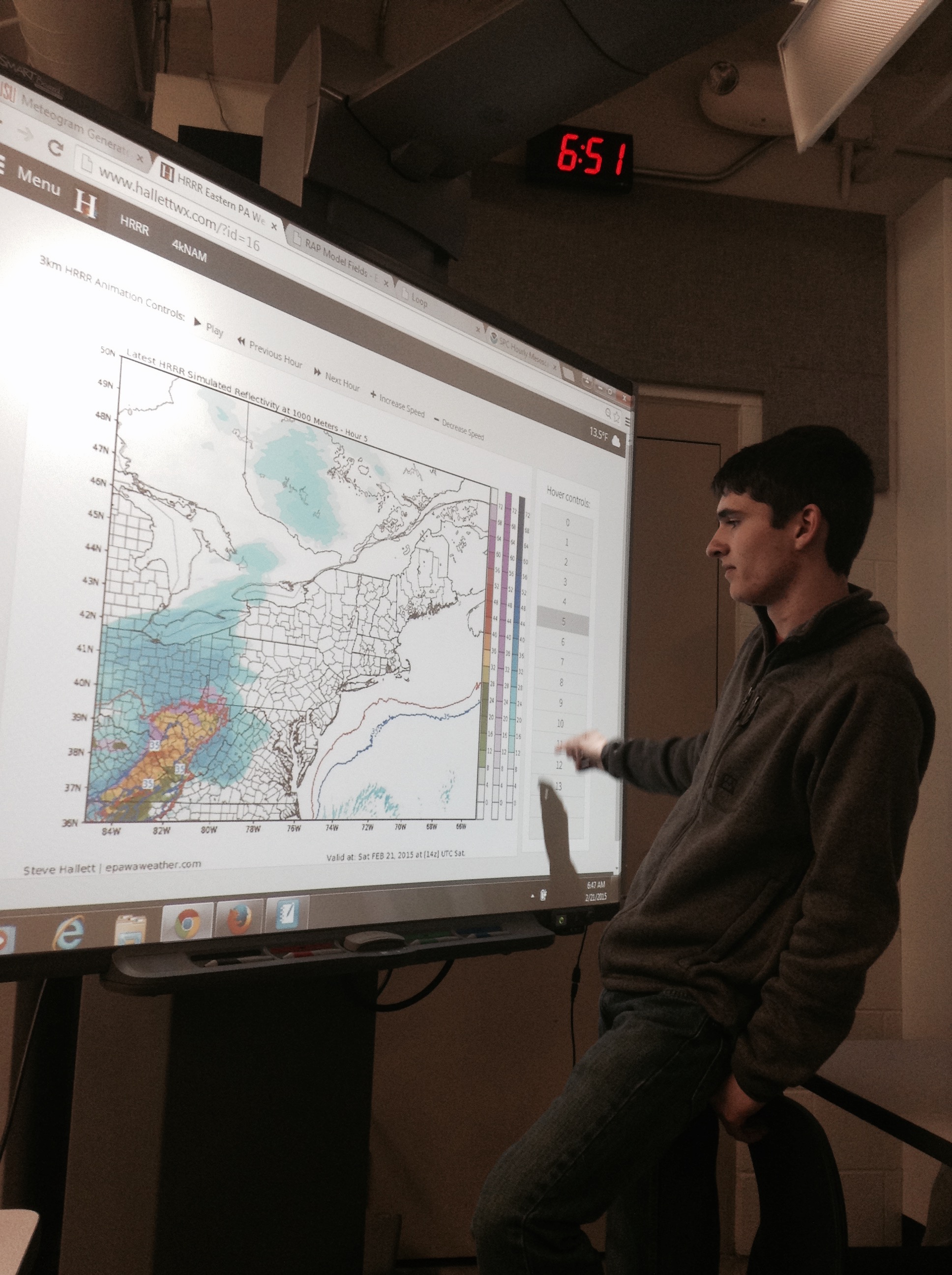
Andy Moffitt analyzing model output regarding an oncoming snowstorm during THON weekend.
Hazardous Weather Briefing Partnership with Campus Weather Service:
ClubEM continues to work with PSUOEM to provide weather briefing packages during events where increased situational awareness is deemed necessary for university operations. This service began in the Fall 2013 semester and will continue, with improvements, this year. One major change to the service was an official partnership with the Campus Weather Service (CWS), implemented in the Spring 2014 semester. This partnership allows PSUOEM to draw from a larger pool of meteorological expertise while giving students the opportunity to improve decision support capabilities.
See our working document:
Meteorological Situational Awareness
Fall 2013:
2013 THIRA:
ClubEM’s first task as an official student organization was the 2013 Threat Hazard Identification Risk Assessment (THIRA). This project was handed to ClubEM by PSUOEM who asked that the club research, analyze, and assess a predetermined list of natural, technological, and human-based hazards. This list was developed by PSUOEM based on Federal Emergency Management Agency (FEMA) guidelines for THIRA. At the time of assignment, ClubEM was primarily comprised of students studying meteorology, geology, geography, and geosciences. The background of the student members allowed the club to quickly create assessments for the natural hazards. Some members were able to tackle technological hazard assessments but the club realized the need for outside help to assess most non-natural hazards. ClubEM enlisted the help of Penn State’s Red Cell Analytics Club (RCAL) to complete the assessment of these non-natural hazards. With the help of RCAL, the 2013 THIRA was completed and submitted to PSUOEM by November 2013. The assessments provided were utilized in the university’s administrative work on the 2013 THIRA.
Hazardous Weather Briefings for PSUOEM:
During the 2013 Fall semester, many incidents of hazardous weather occurred in University Park, Pennsylvania. Some of these events occurred during major campus events such as home football games, various sporting tournaments, and concerts/performances. In advance of these events, PSUOEM requested that ClubEM student meteorologists prepare and submit weather briefings to be utilized in event planning. These weather briefings were compiled individually by members, submitted for review, and then officially submitted to PSUOEM. Student meteorologists provided a short term forecast, hazard-specific forecast, and any recommendations that they saw fit for operational planning. During events where weather briefings were requested, ClubEM enlisted the help of the Campus Weather Service (CWS), a Department of Meteorology student organization, to assist in development of the briefs.
Typhoon Haiyan/Yolanda Crisis Mapping in the Philippines:
In early November 2013, Typhoon Haiyan (also known as Typhoon Yolanda) made landfall with incredible strength in the Philippines. ClubEM members from the Department of Meteorology engaged in independent forecasting of the storm days before the landfall and noted the devastating strength that the system possessed. After making landfall and exiting the Philippines, members of ClubEM participated in a tutorial on Open Source Mapping (OSM) that was offered through the Department of Geography. Motivated by the extend of the damage that the storm caused, those members who had participated in the tutorial established an Open Source Mapping event for ClubEM. The event was called a “Crisis Mapping Event.” ClubEM hosted this event and invited the Penn State Geographic Information Systems (GIS) Coalition, a student organization, to participate. On Thursday November 21st, ClubEM and the GIS Coalition joined in the Walker Building GIS Laboratory to participate in the event. During the event, students utilized “Openstreetmap.org” to digitally overlay streets and buildings on established open source maps. Members made hundreds of additions to the various projects that “Openstreetmap.org” had created to assist disaster responders in the Philippines.
Community Emergency Response Team Training (CERT):
In the spring of 2014, many of our members (and all of our officers) completed the Community Emergency Response Team Training course provided by the Centre Region Council of Governments. These courses are intended to educate the layperson in the basics of fire suppression, medical emergencies, hazardous material response, and incident management in order to create a more prepared community. These courses do not certify any person to serve in the place of a certified emergency responder (such as an EMT, firefighter, or police officer), but instead gives them the tools to care for themselves and their community in the time it takes for help to arrive.
Disclaimer: http://www.clubs.psu.edu/disclaimer/