
IMAGE OF THE WEEK
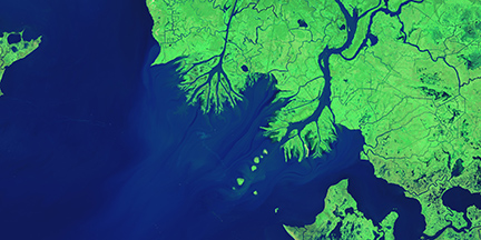
Growing deltas in Atchafalaya Bay. Image Credit: NASA/Earth Observatory
The delta plain of the Mississippi River is disappearing. The lobe-shaped arc of coastal land from the Chandeleur Islands in eastern Louisiana to the Sabine River loses a football field’s worth of land every hour. Put another way, the delta has shrunk by nearly 5,000 square kilometers (2,000 square miles) over the past 80 years. That’s as if most of Delaware had sunk into the sea. Though land losses are widely distributed across the 300 kilometer (200 mile) wide coastal plain of Louisiana, Atchafalaya Bay stands as a notable exception. Read more: http://www.nasa.gov/content/growing-deltas-in-atchafalaya-bay/#.VOITY4cl5e0
GOOD NEWS
Chris Fowler was appointed to the Advisory Board for the Population Research Institute.
NEWS
Coffee Hour: February 20 R. Quinn Thomas “Nitrogen constraints on terrestrial carbon sequestration, from trees to the globe”
The terrestrial carbon cycle is an important driver of global climate. However, plant growth and the associated uptake of carbon from the atmosphere can be limited by the amount of nitrogen in soils. The constraint of nitrogen on carbon sequestration occurs on multiple spatial scales. Here, I explore the interactions between terrestrial carbon and nitrogen cycling at the individual tree, forest stand, and global scale. First, I will highlight research focused on quantifying how atmospheric nitrogen deposition has altered the growth and mortality of trees across the Northeastern U.S. Second, I will explore the sensitivity of forest carbon sequestration to nitrogen deposition. Finally, I will discuss how carbon-nitrogen interactions can be better represented in Earth System Models, a primary tool for predicting future climate.
- 3:30 to 5:00 p.m.
- Refreshments are offered in 319 Walker Building at 3:30 p.m.
- The lecture begins in 112 Walker Building at 4:00 p.m.
- Coffee Hour To Go
Ebola response by NGA marks first step in ‘unprecedented’ move toward data transparency
When the U.S. government decided to put boots on the ground in West Africa last fall to help staunch an emerging Ebola epidemic, agencies needed a lot of highly- trained medical and logistics personnel. But they also needed reliable maps — something Liberia didn’t have at the time.
It does now, because local officials, overseas governments and the National Geospatial-Intelligence Agency agreed to work together in an open data framework. NGA led the effort to develop that geographic information in exquisite layers of detail in the span of just a few months, and posted the results on the open Web in real-time.
Small farmers hold the key to seed diversity: researchers
Up to 75 percent of the seeds needed to produce the world’s diverse food crops are held by small farmers, researchers said following a review of international census data.
Growers with farms of less than seven acres preserve diversity through “networks of seed and knowledge exchanges”, Karl Zimmerer, a Penn State University geography professor who led the research, told a conference of the American Association for the Advancement of Science on Friday.
Map: The Most Common* Job In Every State
*We used data from the Census Bureau, which has two catch-all categories: “managers not elsewhere classified” and “salespersons not elsewhere classified.” Because those categories are broad and vague to the point of meaninglessness, we excluded them from our map.
Recently (or soon to be) published
Shackleton, S., Ziervogel, G., Sallu, S., Gill, T. and Tschakert, P. (2015), Why is socially-just climate change adaptation in sub-Saharan Africa so challenging? A review of barriers identified from empirical cases. WIREs Clim Change. doi: 10.1002/wcc.335
To enhance understanding of the process of climate change adaptation and to facilitate the planning and implementation of socially-just adaptation strategies, deeper consideration of the factors that impede adaptation is required. In response, scholars have increasingly identified barriers to adaptation in the literature. But, despite this progress, knowledge of barriers that hamper adaptation in developing countries remains limited, especially in relation to underlying causes of vulnerability and low adaptive capacity. To further improve understanding of barriers to adaptation and identify gaps in the state-of-the-art knowledge, we undertook a synthesis of empirical literature from sub-Saharan Africa focusing on vulnerable, natural resource-dependent communities and livelihoods.
Calvert, K. From ‘energy geography’ to ‘energy geographies’: Perspectives on a fertile academic borderland Progress in Human Geography 0309132514566343, first published on January 21, 2015 doi:10.1177/0309132514566343
This paper takes stock of geographical contributions to the study of energy and energy futures. The paper is written in two parts. First, I trace the methodological and philosophical traditions that underpin geographical approaches to energy studies. I argue that while ‘energy geography’ is arguably a pragmatic shorthand with which to communicate to the broader energy studies community, geographical studies of energy have expanded in scope and theoretical plurality so that ‘energy geographies’ is a more appropriate label. Energy geographers are well positioned to contribute to scientific and policy debates surrounding energy due to their privileged position at the borderland between various philosophical and methodological traditions. Second, I identify some of the problems, opportunities and uncertainties that contemporary energy geographers are helping to identify, understand, and resolve.
Leah Wasser, Laura Chasmer, Rick Day, and Alan Taylor 2015. Quantifying land use effects on forested riparian buffer vegetation structure using LiDAR data. Ecosphere 6:art10. http://dx.doi.org/10.1890/ES14-00204.1
Quantifying variability of forested riparian buffer (FRB) vegetation structure with variation in adjacent land use supports an understanding of how anthropogenic disturbance influences the ability of riparian systems to perform ecosystem services. However, quantifying FRB structure over large regions is a challenge and requires efficient data collection and processing methods that integrate conventional in situ vegetation sampling with remote sensing data. This study uses automated algorithms to process airborne light detection and ranging (LiDAR) data for mapping of riparian vegetation height, canopy cover and corridor width along 5,900 transects using methods validated in 80 mensuration plots in central Pennsylvania, USA. The key objective of this study was to use airborne LiDAR data to quantify differences in edge vs interior vegetation structure as influenced by buffer width and adjacent land use type, continuously throughout a watershed. http://www.esajournals.org/doi/abs/10.1890/ES14-00204.1
DOG OF THE WEEK

Who is this dog? Who is his human?
Last week’s dog was Bonzer, companion to Andrew Carleton. Send your answer and/or a photo of your dog to geography@psu.edu for our mystery dog of the week!