

Public Domain Photo.
(Click here to listen to an audio version of this blog!)
About 30 miles east of Omaha it started to rain. Not a thunderstorm kind of rain (which you would expect in the summer in these “continental climate” regions) but a wide, low, gray cloud kind of rain, quiet and steady, and only occasionally rising up into short-lived, hard downpours. Over the confusing confluence of highways in Council Bluffs, just before we crossed the Missouri River, there was a full arc of a rainbow that “touched” ground on either of its ends. We drove under it several times before we realized that our smart phone navigator was confused by all of the construction and detours.

Missouri River. Photo by A. Eminov, Flickr
The Missouri River is an iconic geographic landmark. I remember the first time I saw it back July 1967. I was in Sioux City, Iowa with some of my cousins. We had come over to just see a city for an afternoon (we had been out on the farm for almost two months!). We felt the need for people, and cars and bustle. There was also a new John Wayne movie at the theater in Sioux City (“The War Wagon”! A perfect choice for a group of teen-aged boys!), and we planned to hang out, get some lunch and then catch a matinee.
I remember walking along up over the river thinking about Louis and Clark and the Corps of Discovery Expedition and all of the other adventures the Missouri has seen. Its watershed off to the north and west seemed like the essence of the wild west itself.

Photo by Roger, Flickr
We went into a department store just to catch some air conditioning and kill a little time before the movie started, and there in the center of the store were four, life size, cardboard cutouts of the Beatles in their Sergeant Pepper’ uniforms. The album had come out six weeks before, but none of us had heard about it. The colors were insane. I loved the Beatles but had they lost their minds? “….. I read the news the news today, oh, boy ….” The album quickly became and still is one of my favorites. Maybe we all went a little insane for the better because of that music.
Back to July, 2020: Deborah and I stopped for the night and stayed in a motel not far from the river. There was a swimming pool, a fitness center and a complimentary breakfast bar at the motel. We skipped them all, though, because of the COVID pandemic. We were traveling as self-contained as possible (breakfasts and lunches came out of our transported food bag and cooler). We had squirt bottles of hand sanitizer all through the car ( a couple of them spilled out onto the back seat, and the car still smells like Purell). We also had two containers of disinfecting wipes to clean ourselves up from our stops at rest areas, and a box of latex gloves to seal us off from the oft-touched screens and buttons at the Interstate gas stations. For dinners we splurged with drive-through fast food or Door Dash delivery. In Omaha that evening, we got some very good deli sandwiches and salads delivered to our room.
An interesting side note: back at the beginning of our trip almost everyone was wearing masks at the rest stops and gas stations along the highway. The further west we drove, though, the fewer people were wearing masks. Here in Nebraska, in fact, Deborah and I were in a distinct minority by being masked up!

Photo by D. Sillman
Izzy was still having issues about being in the car (but after an hour or two of morning fussing she quieted down and let her serotonin- specific- re-uptake-inhibitor do its job. She did enjoy the motels, though. The picture to the left is her lounging on the bed watching the movie “Up” (she’s a big Ed Asner fan!).
Interstate 80 across Nebraska follows the north branch of the Platte River. You cross and re-cross the Platte as you drive along, but you can always tell which side of the road the river is on by the dense, stands of cedars, willows and locust trees that hug and screen off the river bank. The non-river side of the road is usually irrigated fields of corn or soybeans or mowed grassland that extends on and on toward the horizon. The huge, movable irrigation rigs spray clouds of water out over the fields. They even run while it was raining! Have to stay on schedule, I guess.
We are gaining altitude with each passing mile. Lincoln is just 100 feet higher than Omaha, but then Grand Island is 665 feet higher than Lincoln, and Kearney is 311 feet higher than Grand Island. Ogalala is another 1070 feet higher than Kearney. Ogalala is 3222 feet above sea level, and our ultimate destination, Greeley Colorado, is 1453 feet higher than that (it is 4675 feet above sea level). We are climbing the long, steady shoulder up onto the backbone of the Great Plains . Then, it’s a just short hop up to the Rocky Mountains!

Photo by D. Sillman
Nebraska has a very distinctive landscape. There are fields of corn and soybeans, and all of them are irrigated. Occasionally there is a field left fallow and un-watered. These fields stand out starkly in the human generated swath of green. They are covered with brown, very dry grasses, and look ready to catch fire. Solid-looking, solitary trees stand in the grass/weed rows in between the fields and also between the road and the adjacent fields. At a distance the trees look like cottonwoods although some of them may be burr oaks or even silver maples. Passing at 80 miles per hour makes species identification difficult. At the rest stops all three of these trees were planted very widely spaced from each other along with some hardy looking honey locusts. There is no continuous shade at the rest areas nor is there any along the highway. Tiny islands of relief from the pounding sun are all that can be found.
I read somewhere that there have been various programs to plant trees along I-80 to make the road more pleasing and welcoming. Cottonwoods, in particular, are the species chosen for these efforts. Their thick trunks and spreading branches are both natural looking and also very incongruous in this dry climate. Each planted tree is step away from a prairie and at least half a step toward a savanna.
Somewhere along the Nebraska I-80 we left the tall grass prairie and entered the zone of mixed grasses (the “mixed grass prairie”). The mixed grass prairie is an ecotone between two very well defined biomes. Species from the tall grass prairie biome mix in with species from the short grass prairie biome and generate a stable ground cover of grasses and forbs (a “forb,” by the way, is a flowering plant that is neither woody nor a grass).

Photo by D. Sillman
As the climate continues to dry with the rising altitude and increasing continentality of location, the short grass prairie plants start to dominate and the ecotone becomes less and less apparent. The short grass prairie, like the other pre-colonization biomes we have discussed, has also been greatly reduced, but more of it persists than eastern forests or tall grass prairies probably because it is so dry and not nearly as productive or as “useful” to humans.
About half of the original short grass prairie remains spread across the center of the continental mass up to the eastern side of the Rocky’s. It is a region of extreme summer drought (although, ironically, today we are driving through it in a summer rain storm!). There are two dominant grasses that make up between 70 and 90% of the plants in these prairies: blue gama and buffalo grass. It was home to great herds of wandering bison and pronghorns and billions upon billions of prairie dogs. The prairie dogs, in particular, kept the short grasses vital and sustainable. Because of their influence on nutrient flow and soil quality prairie dogs are now recognized as a keystone species in these systems rather than as annoying pests (see Signs of Fall 4, October 3, 2019).
Fire is an even more frequent occurrence in these dry grasslands than it is in the wetter prairies back east. On average, a natural, short grass prairie system burns every 5 to 10 years. Invading shrubs and trees get scoured out of the system in these blazes and the endemic grasses thrive.
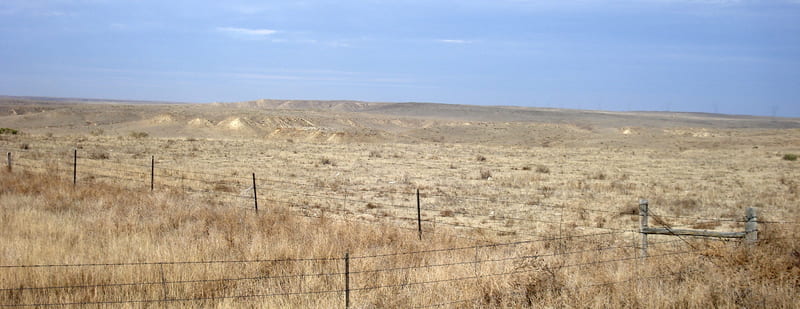
Photo by A. Eminov, Flickr
We left I-80 and took I-76 southwest into the eastern plains of Colorado. The suddenness of the change in scenery was remarkable! The orderly, green, irrigated fields of western Nebraska were replaced by the brown, dry, sagebrush of the Colorado high plains. Every few miles someone had an irrigated field of corn, but mostly, mile after mile, the scattered vegetation and expanses of bare, light brown, sandy soil dominated the view. We were driving just south of the Pawnee National Grassland but saw no signs that indicated its presence.
The roads went on arrow straight. The hours just raced by as we got closer and closer to Greeley. On the outskirts of Greeley we could finally see the eastern range of the Rocky Mountains just 40 miles away. There was still snow on the tallest peaks, and the mountains seemed to float on a buoyant haze. The navigating voice from the Smart Phone took us left then right then left again. We entered a shady, tree-lined curve of streets and then were finally at our new home.
A fascinating trip and biologist description. Terrific. Best of luck to both of you.