A niche model can allow scientists to examine climatic preferences of a certain species by modeling their distribution. Certain factors such as precipitation and temperature allow us to examine those habit preferences. One might imagine that to construct something like this, it would require the very exact location of where a bird, mammal, or in our case, insect was caught. As I have explained before in previous blog posts, however, georeferencing the exact locations something is caught is not always possible to do- especially when you are processing specimens that were collected before a time that one could readily obtain GPS coordinates. Before you begin creating a niche model, I think it is important to understand that said niche model will never be perfect. You must leave your perfectionism at the door before beginning.
Below I will outline the steps I went through to find an acceptable (by my own standards) locality:
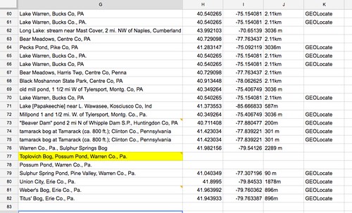
- Above, highlighted in yellow is a location that has not been easily found through a combination of Google Maps and Tulane University’s GEOLocate platform. I must now put some elbow-grease into finding Toplovich Bog.
2. A series of blog posts and travel sites tells me Toplovich Bog exists. There is even a field trip scheduled to visit Toplovich Bog next week. If anyone is interested, there is a group planning to leave from the Westfield McDonald’s parking lot at 9:30 AM on July, 16th. But they don’t give me coordinates. Thanks a lot!
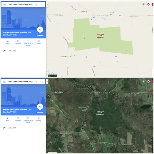
3. With a few lucky Google posts I come across this map. This map details the recreation opportunities in Warren County. After reading that this bog was very close to the border on other websites, I began to look for any reference to Toplovich Bog. Do you see it? Upper left corner!
4. I now have a general idea of where this bog is. I can now begin to explore this area with Google Maps. If you reference back to the map, it shows that Toplovich Bog is underneath State Game Lands Number 197. We can even double-check ourselves by comparing the streets of the Warren County map and Google Map results.
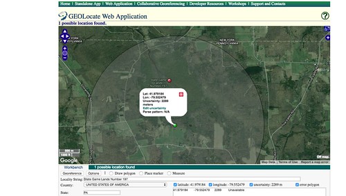
5. Now we are ready to Georeference this locality and get the coordinates. Using everything I know from previous information on the bog I can place a marker to obtain the coordinates of the general area. These coordinates will represent the location of the catch and is essential to our modeling. After all that interweb searching we are done! Only 300+ localities to georeference!
So, I must ask, are my own standards acceptable? I started with a blog and worked my way up. Throughout my undergraduate career I was always told to be wary of less than reputable sources and strive to be near-perfect when carrying out an experiment. Is that attitude applicable in this field of science? I think realistically, we simply cannot perform at that level of perfectionism when georeferencing locations with no given coordinates. You can either assume a location to the best of your abilities or you can throw the sample out of your model. I would enjoy hearing other’s perspectives!
Leave a Reply