Alright, so I haven’t been great about keeping this website updated, though the Young Researcher Spotlight article in February at least prompted me to update and upload my CV. Which, I guess I’ll have to do again because I’ve got some good news: the GSA Bulletin article describing my master’s thesis work is online, and I’ve been told that ESPL accepted my manuscript from my undergrad thesis! It was a pretty good week, and it ended with a trip to Boulder for CSDMS 2018, for which I am super pumped! Julia and I are excited to learn literally anything about building models and coding. I did say to myself that at the start of my PhD I’d move from Matlab to Python, but that’s only gone….ok so far.
What else happened this semester? The Shale Hills CZO just finished off a great All Hands meeting, I learned how to conduct my own seismic and ERT surveys, and I presented that project on waterfalls from back in the day, and I really want to pick up that project and get that written up sometime this fall. It only needs probably a day or two more of fieldwork, and then it’d be good to go, I think.
Other things I started doing recently was getting into rock climbing at the bouldering wall at Penn State as well as growing my own veggies (despite my absence very soon for field camp, which departs for YBRA June 4th!). It’ll be a busy summer but a good one, infinitely better than trying to finish off two manuscripts while heading a caravan of ten SUVs full of weary geologists.
Since I’m not registered for any classes this semester, I tried to fill my time and energy with extra-curricular endeavors. I’m proud to describe two of these projects here!
First, as an idea that began early last fall, I’m working with Shaver’s Creek Environmental Center, whose staff instructs a course on natural and cultural history interpretation for undergraduate “SEED” students majoring in Recreation, Parks, and Tourism Management, outdoor education, and other majors that like being outside and learning and teaching about the environment. Both the Shale Hills CZO scientist and staff at Shaver’s Creek are interested in educating the public about the importance of studying the natural world and recognizing the effects of human-environment interaction and climate and land-use change. We decided on a project that involves pre-existing trails around the Environmental Center that intersect study sites around the CZO. Along this “science loop,” hikers would pass by a notched weir, cross a geologic contact, and observe the numerous permanent observation sites along the ridgelines measuring properties of soil, carbon and water. The SEED students are tasked with taking some of the more technical scientific information put out by CZO scientists and interpreting these sites for the general public.
SSHCZO is working with a museum team and PSU undergrads to implement CZ ideas into displays and nature trails. @Shavers Creek does it right! https://t.co/1OiKhVW44I
Later in the semester, these students will take their interpretive materials and turn them into an “e-trail guide,” designed to augment visitors’ hikes with multimedia informational displays. Stay tuned for that outcome!
A second project with which I am involved is a new coalition of students and some faculty called We Are For Science, and it’s a group of science workers interested in promoting science in policy and science communication, as well as diversity and inclusion within the sciences. I’m focusing on the latter – after November 9th, I wanted to show my friends and colleagues that I was their ally in what would be a difficult time in navigating an atmosphere of fear, hatred and closed-mindedness. I worried about my classmates and fellow scientists – women, religious minorities, people of color – and I wanted their work to be taken seriously, and for them to feel safe and welcomed in my department and scientific discipline. Attending a liberal arts school in southern California equipped me with the language and tools to address inequality and privilege, but there never seemed to be as dire of a time to employ that knowledge as their is now. My hope is that the few events we’ve planned – student mixers aimed at POCs, inviting speakers who can tell their stories about being an under-represented group or recruiting minority student – will do a little bit in making our little bubble of academia more welcoming to groups who face systematic discrimination. If you’re reading this, and have any advice or questions, I would be very interested in learning more.
Wow, where did November and December go? Having three final projects in addition to AGU data interpretation and poster-making certainly makes for an exciting end of a semester. Here is the briefest of overviews!
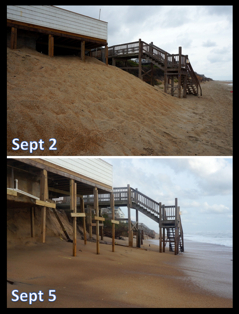
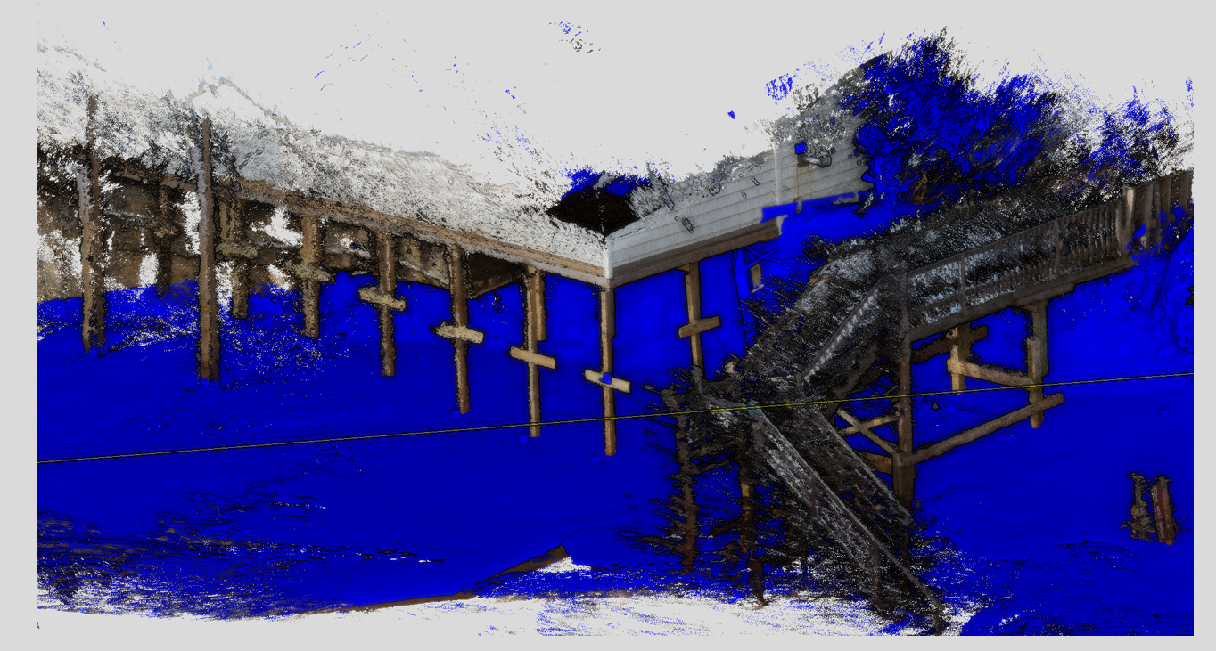
Photogrammetry seminar final project – I used ground-based imagery (photos) before and after Tropical Storm Hermine blew past Duck, NC to see if I could quantify beach erosion in a simple workflow that might be doable for citizen scientists:
This is what the beach looked like before and after the storm – looks like adding sand under their swimming pool didn’t help!Here’s the colorized point cloud of the deck and the blue “bare-earth” beach surface after I manually removed the structuresThis is the workflow I propose for implementing citizen-science photography and photogrammetry into coastal research endeavors.
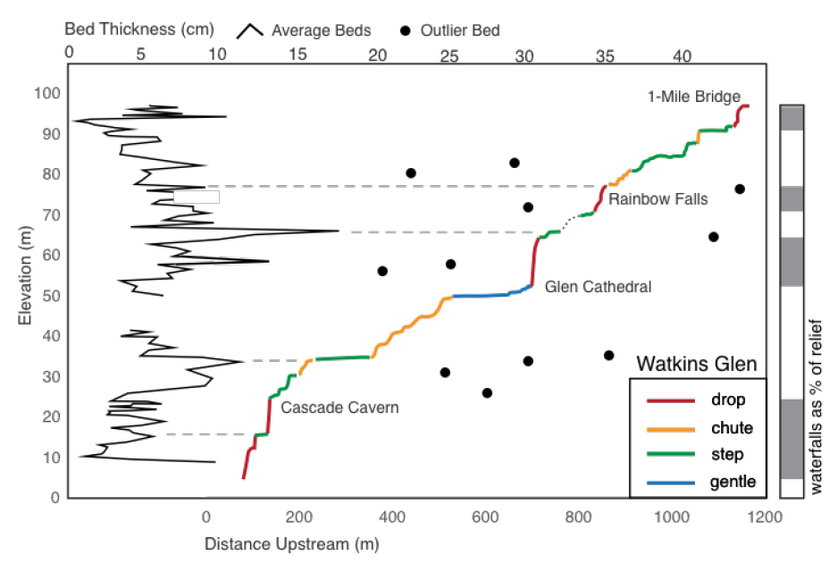
2) Surface Processes final project: You read a bit about the fieldwork and photogrammetry work before, but we actually found a decent relationship between the stratigraphy and the tops and bottoms of waterfalls:
At Wakins Glen, we can see that a few coarsening-upwards sequences, with their erodible shaley bottoms and thicker sandy caprocks, often correspond to the tops and bottoms of waterfalls.
If, The Internet, you are reading this and want to know more about this project (I gave a wee pop-up presentation at Gilbert Club!) you should lemme know – I think it’s a super cool result from basically not a lot of fieldwork, and the data is digitized so it can be revisited in the future!
3) The Big Kahuna, AGU
Wow, what another year of science and reuniting with old friends! This year I tried to pace myself for the week, which seems to be back-loaded with geomorphology. I took daily naps to keep spirits high, but I also spent my evenings meeting with good friends from Pomona, CZO fieldwork and even some classmates from when I studied abroad at the University of Edinburgh! It’s so funny how geologists might disperse over the years, but you always end up seeing familiar faces at conferences. It’s one of the nicer aspects of the field. And of course there’s Gilbert Club, where the Mafia family that is the geomorph community comes together to hear about some of the latest and greatest work in the field. It was especially great to hear from Nicole Gasparini of Tulane, who reminded everyone in the room how valuable it is to make our science and our community accessible to all sorts of people, especially under-represented groups. Afterwards I chatted with her briefly and let her know that yes, indeed, young female geomorphologists have few female role models to look up to, and it meant a lot for me to see one of the few women I can even cite say this (check the author list of your next bedrock rivers/tectonic geomorph paper to see what I mean).
This is all I have time to write for now, but perhaps I’ll start the semester with another post. This is the last spring of my MS at Penn State, so the writing shall begin in earnest! Wish me luck, and smell ya later 2016!
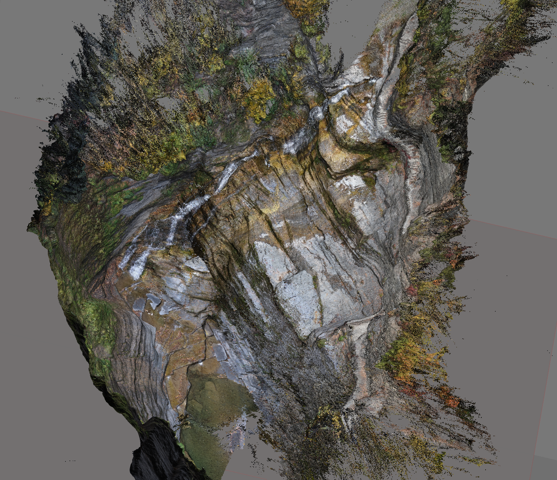
What better time than mid-October for a trip up to the Finger Lakes? Our Advanced Surface Processes class spent a long weekend studying the waterfalls and channels around Seneca and Cayuga Lakes. Some students made measurements of rock strength, fractures and bedload volume and size. My partner Evan and I decided to study how the stratigraphy affects the location and morphology of waterfalls. Evan is a stratigrapher and I’ve had experience with bedrock streams,so we were well-equipped! We also both used photogrammetry in the past so we decided to make models of the stratigraphy and waterfalls with Structure from Motion in addition to traditional stratigraphic measurements.
Right now we’re in the process of reconciling our field measurements via laser ranger, orthorectified mosaics and LiDAR. But I also took the time to build a whole model of Lucifer Falls, the big drop in Treman State Park near Ithaca.
This is what Lucifer Falls looks like to any old tourist…
…and this is what the colorized, georeferenced point cloud looks like when you use photos from lots of different angles to create a model in Agisoft Photoscan! We can upload the dense cloud directly to a program like Cloud Compare to make measurements of fracture orientations or spacing. I’m using the model to cross-check our measurements we made in the field and the NY state 2 meter LiDAR.
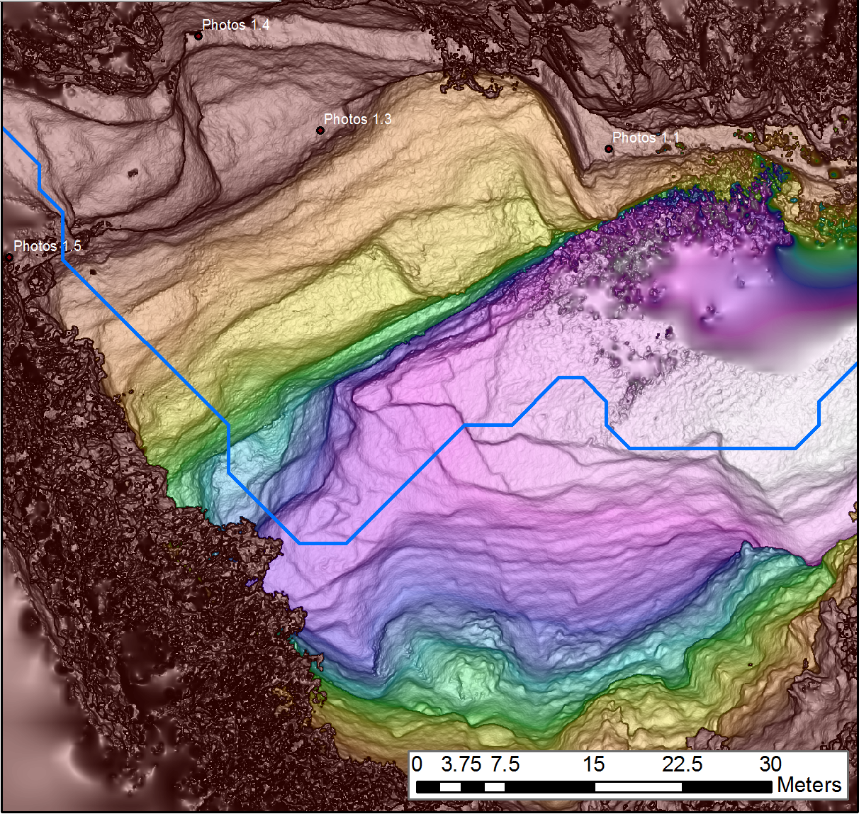
I also used Photoscan to create a DEM from the dense point cloud. It’s a little funny lookin’ with the trees in the way, but I’ve zoomed into the gorge part of the DEM with the photolocations as well as the stream network derived from the 2m LiDAR. Ain’t it beautiful?
Stay tuned for the outcome of our stratigraphy measurements! Here are other great pics until then:
Pretty!Look at that attractive buncha geomorphologistsEvan and I didn’t think to download a photo-annotating app before heading out, so we had to take our notes with Snapchat