Finding spatial data that is publicly available for niche subjects can be a difficult and time-consuming task. Using the resources available from the library along with software provided by Penn State it is now easier than ever to create your own spatial data. In this blog post we will be discussing what resources are available to library patrons at Penn State that enable you to create your own spatial data. The Donald W. Hamer Center for Maps and Geospatial Information in the Pattee Library at Penn State has a variety of GPS units and equipment available. We decided to use the Bad Elf Flex to create our own spatial data because it is easy to learn how to use, very accurate, and can be easily used with ArcGIS Field Maps. ArcGIS Field Maps is an app that allows the user to create points on a map using either their smartphone’s integrated GPS or a connected GPS unit. The Bad Elf Flex can be connected to any smartphone with Bluetooth and can easily be selected as the GPS position provider in the ArcGIS Field Maps app.
For more information on the Bad Elf unit and ArcGIS Field Maps See this former library blog post and Story Map from Bad Elf:
To show users an example of creating spatial data on your own, we used the Bad Elf unit and ArcGIS Field Maps together to create some arbitrary data about the ground cover types found on campus near the Pattee Library and Pattee mall. We also wanted to test the differences in accuracy between the Bad Elf unit and the integrated GPS within our cellphones. Before collecting any data there is a considerable amount of set up that needs to be done. First you need to create a feature layer in rc ArcGIS online that is appropriate for the data you want to capture (Point, Line, or Polygon) and decide what other information you want to record with that data. Then you need to set up ArcGIS Field Maps on a mobile device and connect the Bad Elf unit to your phone. These steps are explained in detail within the guide from Bad Elf unit linked above. After all this set up, you are ready to begin going out and sampling your data using the Bad Elf unit.
There are some best practices that should be mentioned to create high accuracy data using the Bad Elf unit. First, we advise that you use the pole, or the tripod stands to elevate the GPS and provide stability (see image below). Additionally at each point where you are collecting data you want to place the GPS and ensure it stays steady so that the spatial error of the data recorded will be reduced. ArcGIS Field Maps provides a live reading of what the error is as you are taking the point and records the spatial error with the data as you create it. Once the GPS “settles” you will see the error stop going down and at this point you should collect the point and all the other information associated that you desire. You should avoid large physical barriers, like buildings or trees, between the GPS and the sky above as this disrupts the pathways that allow the Bad Elf unit to connect to the satellites above. We directly tested this in the data layer that we have shared below.

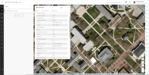
Here are some images of us collecting this sample data and what that data looks like on ArcGIS online after we have collected it:


Overall, we found that creating spatial data with the Bad Elf Flex unit is an extremely powerful resource that the library has to offer. The process does require a bit of learning to set up and properly record data but works very well once the user is accustomed to the process. We recommend doing a few tests to ensure you have configured everything to your liking before spending lots of time and energy recording your data. To borrow the Bad Elf Flex unit and any of the other accessories available for spatial data creation come to the Maps and Geospatial center to learn more.
Here are the catalog links to the Bad Elf Flex and Tripod we used in this blog post:
Fin is a fourth-year student at Penn State majoring in Geography and minoring in Soil Science. Fin has had multiple lab research positions where he has contributed to creating spatial data for forest biogeography and forestry research. Fin’s other interests include using drones to collect geospatial data, competing with the PSU soil Judging team and spending time outdoors. Fin has been working at the Donald W. Hamer Center for Maps and Geospatial Information since February 2022.
Brady is a fourth-year student at Penn State majoring in History and minoring in Geography and GIS. Brady has been working at the Donald W. Hamer Center for Maps and Geospatial Information since August 2022. From August 2022 to February 2023, Brady worked as the Historical Aerial Imagery Bednar Intern at the Donald W. Hamer Center, where he created a detailed inventory of a large collection of historical aerial imagery in the library’s collection and created a Story Map highlighting the collection. Brady’s other interests include creating 3D models of terrain data and participating in Penn State Club Sailing.
Leave a Reply