Category Archives: Uncategorized

Great Barrier Reef, Australia

barrier reef

So this this week’s place isn’t really a weird place, but it’s most definitely a spectacle and easily accessible to tourists. This week location is the Great Barrier Reef off the eastern coast of Australia. It is the world’s largest coral reef, and also the world’s largest living ecosystem at 3,000 kilometers, or about 1,800 miles. That’s the same area as Italy, Japan, Germany, and Malaysia (not combined, but that still pretty huge). It is composed of over 3,000 individual reef systems, 100 species of jellyfish, 3,000 species of mollusks, 500 species of worms, 1625 types of fish, 133 varieties of sharks and rays, and more than 30 species of whales and dolphins.

The Great Barrier Reef is thought to be the product of the Australian tectonic plate movement during the Cenozoic Eastern Australia experience a period of tectonic uplift, in addition to volcanic eruptions that created basalt flows. This caused the Coral Sea Basin to form and coral reefs began to grow. However, the water was too cool for coral to proliferate until about 25 million years ago. After years of unsuitable climate for reef growth, the earliest evidence of complete reef structures dates back about 600,000 years. At that point, sea level was 120 meters (or 390 feet) lower than it is today. As ocean level rose, coral built on each other to create the outstanding reef we see today. It is now composed of living coral growing off of dead coral that dates back almost 20 million years. The dead coral has gradually formed into a large wall of stone covered in the living coral, algae, anemones, sponges, fish, worms, starfish, turtles, mollusks, snakes, and crustaceans, with fish and marine mammals living off this lively cover.

It is believed that the Great Barrier Reef was first seen in 1522 by Portuguese explorers, potentially led by Cristovao de Mendonca. However, the reef was also recorded by Scandinavian explorer Willem Jansz in 1606, and also by Luis de Torres, who was actually the first Jewish American settler (shoutout to Idan, bet you didn’t know that piece of Jewish history). However, these glimpse were nothing compared to the exploration done today. Today’s researchers study the makeup of the reef, the species that inhabit the area, how they live and interact with each other, and whether or not the reef is susceptible to change.

Unfortunately, this beauty is in a lot of danger, caused by many environmental threats. Due to climate change, the northern parts of the reef are experiencing the worst cases of bleaching ever recorded. Bleaching occurs when the coral loses its color when the water gets too warm. According to Michael Slezak of The Guardian, a court case is set to begin next month; Great Barrier Reef vs. coalmine. The Australian Conservation Foundation will take the federal environment minister to the federal court to challenge his approval for the Indian company Adani to mine in Queensland. They are accusing the minister of failing to recognize the damage that burning coal will do to the reef. “If the ACF wins, and the mine’s approval is overturned, it would be the first time courts have ruled that the emissions released when coal from a development is burned are a relevant impact under the key piece of federal environmental legislation,” says Slezak.

The Great Barrier Reef is most definitely one of Earth’s greatest gifts, so it is essential for you adventurers to take advantage of its beauty now before it’s too late!

Cueva de los Cristales, Mexico

crystal cave

Hello friends, this week’s passion blog post is about the Giant Crystal Cave in Chihuahua, Mexico! The cave is 300 meters (or 980 feet) deep and 27 meters (or 89 feet) long. The crystals are made of hydrated limestone, or for those chemistry buffs out there, gypsum calcium sulfate (gypsum CaSO4·2 H2O).

The cave lies right above an ancient fault that is above an underground magma chamber. The magma heats the ground water, which is saturated with sulfide ions (more info for the chem nerds). When the cool oxygenated surface water combine with the heated ground water they do not mix due to their differing densities; the oxygen diffuses into the heated water and oxidizes the sulfide ions into sulfate ions. Then, the hydrated sulfate gypsum crystallizes at an extremely slow rate of over 500,000 years, which causes the accumulation that forms monstrous sized crystals.

The cave was almost discovered by miners in 1910 beneath the Naica mine workings. The miners found the Cave of Swords, which is a much smaller (but not necessarily less magnificent) crystal cave that is located above the Giant Crystal Cave. Scientists speculate that at this level of the caves, the temperature is much lower, which stunts the growth of crystals in the Cave of Swords. However, the Giant Crystal Cave was discovered in 2000 by miners excavating a new tunnel through the Naica fault, which they thought would flood the mine. The caves are only accessible today because the Industrias Peñoles mining company created pumps that go through the cave and drain the water out of the cave. If the pumps stopped, then the caves would be submerged in water once again. Unfortunately, the crystals deteriorate in air because there is no water to facilitate the chemical reaction needed to produce more crystals. That being said, the Naica Project, a group of scientists that research the caves, are attempting to visually document the crystals before they disappear.

A team of scientists led by Paolo Forti, cave mineral specialist and crystallographer (there’s a job title you probably never knew existed) from Italy’s University of Bologna, explored the cave in detail in 2006. In order to withstand the extreme temperatures and humidity, they team created their own refrigerated suits and cold breathing systems. They used special caving overalls fitted with a bed of refrigerating tubes placed all over the body. The researchers carried a backpack filled with ice water that flowed through the tubes to cool the body sufficiently for about half an hour at a time. In addition to mineral research, biogeochemical (another scientific field unheard of before this post), microbial, palynological (study of pollen), and hydrogeological research have been performed in the caves to gain a better understanding of its ecology.

If you want to explore the cave and see the crystals for yourself, there are some safety precautions to be aware of. The cave is about 136 degrees Fahrenheit with 90 to 99 percent humidity. Because of these extreme conditions, very few people have ever explored the cave. Without proper protection the average person can endure about ten minutes of exposure at a time.

Marble Caves, Chile

marble cave

Another week, another super cool underwater sight to discuss! This week is about the Marble Caves of Chile. This location seems like the perfect paradise. A secluded clear-blue lake hides one of Earth’s most beautiful gems in the water surrounding southern South America. This cave contains crystals the size of four story buildings, and colorful stone that intertwines with one another right before your eyes.

The caves have many names, but the most famous of them is the “Capilla de Mármol,” or the Marble Chapel. They are located on Lake General Carrera of Buenos Aires (but it depends which side of the lake you are on) in Patagonia, Chile. The weather in this area of South America is generally cold and humid. However, the lake itself is sunny and warm, which is enjoyed by the very small population of people that live along the lake.

Before scientists were able to come up with their own explanation for how these extravagant caves were formed, local people have been creating their own explanations. Maori legend states that the huge boulders found on New Zealand’s Moeraki Beach washed ashore materials from the wreck of a mythological canoe needed to form the caves. Meanwhile, an Irish legend claims that the caves were formed by a god-like quarrel that spanned across the Atlantic Ocean all the way to Scotland.

After centuries of rumors, fairytales, and folklore, scientists have finally discovered the true cause of formation of the caves. As time has progressed and pressures on the stone have fluctuated, the caves have been shaped into their current formation by wav erosion. This allows the caves to reveal a marbled effect, and the mesmerizing colors swirled together are enhanced by their reflection in the blue green water of Carrera Lake. Also, the colors presented on the stone changes depending on the lake’s water levels, which are governed by weather patterns and seasons.

The caves flexible appearance causes visitors wanting to come back for more. In the early spring, the shallow waters are turquoise, which creates a crystalline shine against the walls, which allows the walls to look more luminescent. In the summer, the water levels rise and create a dark blue tone, which gives off a deeper and earthy tone on the stone’s surface. The water levels are also affected significantly by the freezing and melting of glaciers, so it is to be expected that as climate change commences, the colors of the Marble Cave will change as well.

After 6,000 years of nature’s hard work, the caves of calcium carbonate now show off bright blue swirls paired with light greens and purples, making this a go-to adventure destination. The caves are very secluded from the mainland, and can only be reached by boat. But that’s okay, because you are surrounded by a stunning crystal blue seas that can only be envisioned in one’s mind. This location is definitely on my travel bucket list, and now I hope it’s on yours as well.

The Marble Caves, Chile

http://www.atlasobscura.com/places/marble-caves-of-chile-chico

http://www.travelandleisure.com/slideshows/worlds-strangest-natural-wonders

http://whenonearth.net/marble-caves-patagonia-chile/


Waitomo Glowworm Caves, New Zealand

glowworm cave

Hello friends and welcome to another installment of… the weirdest places I can find on Google! This one’s for all you bio people out there (also shoutout to Maddie Zalenski because this place reminded me of you and the bioluminescent bacteria) because there is some seriously weird biological stuff going on in this cave I found.

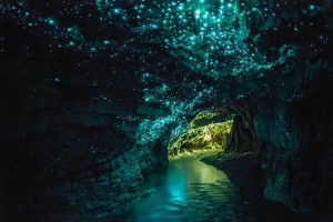
This week’s topic of interest is on the Waitomo Glowworm Caves. The cave is located in deep within the New Zealand hills on North Island. The Maori people of New Zealand have known about this cave for some time, but the cave wasn’t extensively explored until 1887. Maori Chief Tane Tinorau and English surveyor Fred Mace entered the cave via raft by candlelight, and traveled down the stream as it goes underground. This opening is now the exit of the cave. They came across all of these blue lights twinkling over the top of the cave, like in the image above. As the travel deeper and deeper into the cave, they also came across these incredible limestone formations. The pair returned to the cave many times after that and discovered an upper level entrance to the cave, which is now the main entrance.

So like I ask every week, how did this cave form? It’s likely that the cave itself was formed by volcanic activity in the Waitomo region, just like it formed the other 300 known limestone caves in the area for the last 300 million years. The limestone formations have gradually been shaped by the accumulated and compressed layers of fossilized corals, seashells, fish skeletons, and other marine animals. It’s possible that the Waitomo region’s limestone can be over 200m thick. The cave formed when movement within the Earth caused the limestone to bend underwater and rise above the sea floor. As the limestone gained more air exposure, it began to separate, which allowed for water to flow through the cracks and hollow out the structures to form the cave.

The source of the light is quite obvious since it is in the cave’s name; the light comes from the glowworms that reside in the cave. However, they are not actually worms, they are a species of gnat. They are known as Arachnocampa luminosa, a fungus gnat that only reside on the North and South Islands of New Zealand. However, they are usually only seen in their wet larval stage rather than their adult stage, which is their luminescent stage. The glow is a chemical reaction that involves luciferin (a substrate), luciferase (the enzyme that acts upon luciferin), ATP (the body’s energy molecule), and oxygen. Believe it or not, their light is emitted by their excretory system: they excrete a silky web to trap their prey. The hungrier they are, the brighter they glow. Also, the worms practice cannibalism when population densities become too high, or when an adult larvae gets stuck in its own web after hatching.

The best part is, you can visit this cave! There are guided tours that take you through three different levels of the cave. The tour begins at the top level and catacombs, travels to the banquet chamber, then stops at the Cathedral, and finally concluded with Glowworm Grotto. So if you’re planning your summer vacation, keep New Zealand and the Waitomo cave in mind!


http://unusualplaces.org/the-enchanted-glowworm-caves-of-waitomo/

https://en.wikipedia.org/wiki/Waitomo_Glowworm_Caves

https://en.wikipedia.org/wiki/Arachnocampa_luminosa

Gulf of Alaska

gulf of alaska

Another week, another super-cool natural phenomenon to discuss. So far, I’ve brought mostly brought up water around the world that is a different color than the conventional blue. I’ve also brought up the mysteries of the deep abyss of the ocean, naturally spinning whirlpools, and crazy lights in the sky. However more often than not, I’m talking about the ocean. So naturally, it’s time to talk about the ocean and it’s weirdly colored water…again.

Last week, I saw the image above online (probably on tumblr, due to its aesthetically pleasing look). The caption of the photo was “the place where two oceans meet,” which is exactly what it looks like. However, like most things on the internet, you can’t always believe what you see.

With the abrupt change in color transferring from teal to deep-slate blue, many attempt to describe the photo as capturing the collision between the Gulf of Alaska and the Pacific Ocean. There are many other misconceptions revolved around this image. It’s also known as “Where the Baltic and the North Sea meet”, as well as the two types of water that are entirely incapable of ever mixing together.

While the photo is real, the rumors surrounding the mystery are misleading. It was actually taken in 2007 on a research cruise of oceanographers studying the role that iron plays in the Gulf of Alaska, and how that iron reaches certain areas in the northern Pacific. Ocean scientist Ken Bruland snapped the picture while studying how huge eddies, which are slow moving currents, ranging into the hundreds of kilometers in diameter, swirl out from the Alaska coast into the Gulf of Alaska.

These eddies often carry huge quantities of glacial sediment that gets picked up from rivers like Alaska’s 286-mile-long Copper River.  It empties out east of Prince William Sound while containing all that heavy clay and sediment, as well as iron. Once the glacial rivers flow into the larger body of water, they are picked up by ocean currents and begin circulating from east to west. This circulation is how the iron is deposited throughout the iron-deprived regions of the Gulf of Alaska.

In the image of question, the darker section of the water on the right side is iron-rich water. On the left is iron-deprived water. As the iron circulates throughout the Gulf, the light water assimilates with the darker water. However, in a split second, the water can look divided like it does in the image. “They do eventually mix, but you do come across these really strong gradients at these specific moments in time,” Dr. Bruland said. “Such borders are never static, as they move around and disappear altogether, depending on the level of sediment and the whims of the water.”

http://www.adn.com/article/mythbusting-place-where-two-oceans-meet-gulf-alaska

http://soundwaves.usgs.gov/2008/03/


Corryvreckan Maelstrom, Scotland

whirlpool

Within Scotland’s territory between the islands of Scarba and Jura, the Gulf of Corryvreckan holds a mystery: a whirlpool.  As the tide enters the gulf, the current speeds up to 8.5 knots, or about 10 miles per hour.  As these currents meet a seabed with a deep hole and a rising pinnacle, the conditions are perfect to create whirlpools.

The Corryvreckan is the third largest whirlpool in the world, and when flood tides from the Firth of Lorne are added to the whirlpool, the waters of Corryvreckan can produce over 30 foot waves, as well as a roar that can be heard from ten miles away. Fun fact: In 1947, author George Orwell, who was in Jura to complete his internationally famous 1984, almost drowned with his young nieces and nephews after sailing too close to the whirlpool.

Of course when there is a phenomena that can’t be explained, the Scots create a mythological story to explain why this thing occurs. In regards to the whirlpool, there are three different stories that attempt to explain the creation of the whirlpool. In Scottish mythology, the hag goddess of winter, Cailleach Bheur, uses the gulf to wash her “great plaid”, which causes the changing of seasons from fall to winter. As winter approaches, it is believed that the roar is her using the gulf as a washtub. When the washing is complete, the cloth is pure white and becomes the first blanket of snow on the ground. The legend also claims that her occupation of the whirlpool causes “the fiercest of the Highland storm kelpies.” Another legend describes Norse king Breacan attempting to woo a princess. He tried to sail near the whirlpool. However, other people claim that he was attempting to flee from his father’s wrath. Either way, the whirlpool beat him and now the whirlpool may be named after Breacan, or a Gaelic pun on his name. The third legend revolves around Charles Mackay’s poem “The Kelpie of Corrievrackan,” which tells the story of a woman who leaves her lover for sea kelp. She tried to go after the kelp by diving to its home (which just so happens to be at the bottom of the whirlpool). Therefore, she drowns trying to seduce a piece of seaweed. This piece of folklore was meant to be a “warning to fickle maidens,” claiming that if you are unfaithful to your lover, you’ll end up dying.

Scientists also have their own ideas about how the whirlpool was created and continues to spin.  It was initially believed that the whirlpool is caused by strong Atlantic currents hitting a pinnacle of rock sticking up from the seabed, forcing water from the deeper eastern side of the gulf to push up the shallower western side. However, scientists from the Scottish Association for Marine Science (SAMS) have now mapped the seabed using “high-resolution multi-beam echo-sounder” technology, which emits hundreds of sound beams per second to collect information from the echoes to construct detailed seabed maps that revealed that there is no pinnacle at all (gasp!). Instead, the whirlpool is caused by a steep-sided mass of rock protruding from Scarba shore. According to Dr. John Howe, a geologist from SAMS, the survey revealed that due to the powerful currents surging between the two islands, the seabed in the area has been scoured clean. Dr. Howe included, “Any mud and sand on the seabed has been completely swept away. Beyond the whirlpool, the seabed has thus been swept up to form areas of underwater dunes made of very coarse sand that move with the currents.”

Moral of the story: don’t swim in the Gulf of Corryvreckan.

http://www.heraldscotland.com/news/13082973.Mystery_of_Corryvreckan_uncovered_by_scientists/

https://en.wikipedia.org/wiki/Gulf_of_Corryvreckan

Blood Falls, Antartica

bloodfalls

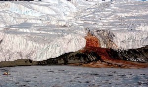
When I think of Antarctica, I think of a serene landscape of frigid air and a slick, icy ground. However, this image completely changed my initial visualization of Antarctica completely. The rich red liquid descending down the Arctic tundra stirs confusion around the stereotypical white icebergs. What causes this bloody river?

This is appropriately called Blood Falls and is located in the McMurdo Dry Valley region of Antarctica. It is nearly five stories high, flows from 7.5 miles inland to the coast, and is one of the coldest and most inhospitable places on Earth; scientists like to compare to the cold, dry deserts of Mars. Jill Mikucki, a geomicrobiologist at the University of Tennessee, Knoxville, discovered a possible cause for Blood Falls in 2009 that continues to be the best explanation for this mystery. The falls are actually a brine, mixed with iron from the bedrock below. As bacteria slowly chew the rock, the iron is released into the brine. The salt water and iron combination creates the distinct, bloody rust color when it mixes with oxygen as it reaches the surface.

The tests of her team showed that the waters of Blood Falls contains almost no oxygen and holds a community of at least 17 different types of microorganisms. This is thought to be flowing from a lake trapped beneath the ice for about 2 million years and may be over three miles deep. Now, Mikucki’s work in this area confirms zones of liquid salt water hundreds of meters below Blood Falls. This underwater zone seems to be the home of a hidden ecosystem of microbial life, which allows scientists to question whether a similar ecosystem could exist on Mars.

This idea spawned a continuation project for Mikucki and her team to further explain Blood Falls and its further represent the potential for life on Mars. Mikucki and her team discovered three main pieces of evidence. First, a genetic analysis of the microbes showed that they were closely related to other microorganisms that use sulfate instead of oxygen for respiration. Second, isotopic analysis of the sulfate molecule’s oxygen atoms revealed that the microbes were modifying sulfate in some form but not using it directly for respiration. Third, the water was enriched with soluble ferrous iron. This would only happen if the organisms had converted insoluble ferric iron to the soluble ferrous form. The best explanation is that the organisms use sulfate as a catalyst to ‘breathe’ with insoluble ferric iron and metabolize the small amounts of organic matter trapped with them years ago. Lab experiments suggested this might be possible, but it never been observed in a natural environment.

“Blood Falls is the only known surface manifestation of these deep brine systems and has been shown to contain a viable ecosystem with numerable microbial cells,” the researchers of Mikucki’s team wrote in their study, “Blood Falls reveals how microbial metabolism can release iron from underlying bedrock, which is ultimately discharged to the surface or below ground to Lake Bonney.” These discoveries may represent not only how life may appear on Mars, but some of the frozen moons of Jupiter as well, which may contain subsurface liquid water.

http://earthsky.org/earth/blood-falls-five-stories-high-seeps-from-an-antarctic-glacier

http://www.huffingtonpost.com/2015/04/29/antarctica-blood-falls_n_7168104.html

Mariana Trench

mariana_everest

As the deepest and darkest location on Earth, the Mariana Trench is the home to many unusual marine life and insane chemical reactions. The trench is crescent shaped, and located in the Western Pacific Ocean, east of the Mariana Islands near Guam.

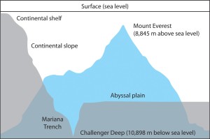
So how deep exactly is the deepest point on Earth? The Challenger Deep is the deepest point within the trench and depths this low are impossible to measure in person due to the crushing pressures of the sea. James Cameron (the guy who directed Titanic who happens to also be a deep-sea explorer) reached the bottom of Challenger Deep at 35,756 feet during a 2012 expedition. However, researchers from the University of New Hampshire used a high-resolution seafloor mapping survey to conclude that Challenger Deep is actually 36,037 feet deep. It is extremely difficult to comprehend how deep that actually is. By comparison, if you were to drive 6.83 miles down the road, that’s equivalent to driving to the bottom if the Mariana Trench. Also, the notoriously tall Mount Everest stands at only 29,026 feet, a mere 7,044 feet shorter than the trench is deep. Also, the trench is 1,580 miles long, which is more than five times the length of the Grand Canyon. Its enormous depth magnitude causes an immense increase in pressure: about 8 tons per square inch. There is more pressure on the bottom of the Mariana Trench than 1,000 times the pressure felt at seas level, which is the equivalent to 50 jumbo jets piled on one person.

The next question to ask is: how was this trench formed? Simply speaking, the Mariana trench formed when two plates on the Earth’s crust collided in the subduction zone, which is the biggest collision sight on the Earth’s surface. According to Nicholas van der Elst, a seismologist at Columbia University, the cold, dense crust sinks back into the mantle and is destroyed at subduction zones. In this case, one piece of oceanic crust is pulled underneath the other and sinks into the Earth’s mantle. This process causes the trench to form above the bend as one plate sinks into the Earth.

Surprisingly enough, scientists have found that there is a very diverse community of marine life that live at the bottom of the Mariana Trench. Food is extremely rare at the bottom because most sources hardly ever make it to the complete bottom of the ocean floor. Accommodate for this scarcity, some microbes feed on chemicals like methane or sulfur, while others scour for other marine life lower on the food chain. There are three organisms most commonly found on the bottom of the trench: xenophyophores, amphipods, and holothurians. The xenophyophores are single-celled organisms similar to a giant amoeba, and gain their nutrition by surrounding and absorbing their food. Amphipods are shrimplike scavengers and the holothurians are a new species of bizarre, luminous sea cucumber. In the Challenger Deep, there are also 200 different microorganisms that have been identified in mud and feed on hydrogen and methane released by chemical reactions between seawater and rocks.

dea527db96a56d54adfc03c15285f2b5

Unfortunately, the Mariana Trench isn’t as easily available as a vacation destination like the other places I’ve written about, but it’s still an amazing feature of our Earth that not many people know about.

http://www.livescience.com/23387-mariana-trench.html


Northern Lights

northernlights

For centuries, ancient Greeks, Chinese, and Scandinavian people have recorded sightings about strange colorful lights in the northern sky. Many cultural groups have legends about the lights. In medieval times, they were seen as omens of war or famine. The Maori of New Zealand as well as many other northern people of Europe and North America believed that the lights were reflections from torches or campfires. The Menominee Indians of Wisconsin believed that the lights determined the location of manabai’wok (giants), which were the spirits of great hunters and fishermen. The Inuit of Alaska believed that the lights were the spirits of the animals they hunted, such as seals, salmon, deer and beluga whales. Other aboriginal peoples believed that the lights were the spirits of their own people. It wasn’t until 1621 when French scientist Pierre Gassendi officially coined the term Aurora Borealis. He named the phenomenon after two Roman gods: Aurora, the goddess of dawn, and Borealis, the god of wind. However, the more popular term used today is the “northern lights” which simply sums up the illuminations in the sky.

How exactly do these lights arise? It is actually collisions between gaseous particles in the Earth’s atmosphere with charged particles released from the sun’s atmosphere. The temperature above the surface of the sun is millions of degrees Celsius. At this temperature, collisions between gas molecules are frequent and release huge amounts of kinetic energy. Free electrons and protons are released from the sun’s atmosphere by the rotation of the sun and escape through holes in the magnetic field. As the charged particles travel towards the earth by the solar wind, they are largely deflected by the earth’s magnetic field. However, the earth’s magnetic field is weaker at the north and south poles, which allows some particles to enter the earth’s atmosphere and collide with gas particles. These collisions emit light that look like the dancing lights at the north and south poles.

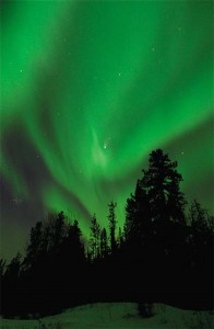
The most common colors viewers have reported are pale green and pink, but people have also experienced shades of red, yellow, green, blue, and violet. The common pale green is produced by oxygen molecules located about 60 miles above the earth. The rare all red auroras are produced by high-altitude oxygen, at heights of up to 200 miles. Collisions with nitrogen molecules produces blue or purplish-red aurora.

Since the particles enter the Earth’s atmosphere through the weakened parts of the magnetic field, the lights can be best places in North America to see the lights are the Northwestern areas of Canada like the Yukon and Nunavut, Northwest Territories and Alaska. However, they have been seen as far south as New Orleans. Other than North America, the northern lights can be seen on southern tip of Greenland and Iceland, the northern coast of Norway, and over the coastal waters north of Siberia. Southern auroras are not seen as often as the northern auroras because they are concentrated in a ring around Antarctica and the southern Indian Ocean.

http://www.northernlightscentre.ca/northernlights.html

This I Believe

Over the summer, my family dreamed of spending our winter break in Disney World. It’s an annual tradition of ours to spend a week of summer vacation at the parks, but summer bridge and soccer camps took priority. However, there was a glimmer of hope as our winter schedules aligned and we planned our annual trip to Orlando for winter break.  Unfortunately, as time went on and our lives became more stressful, the probability of spending Christmas in the most magical place on Earth dwindled to zero. But my mom, the vacation connoisseur, never gave up and planned a day trip for us to New York City.

The day before New Years’ Eve, we set off for our journey to the Big Apple in the most extravagant of all transportation: Greyhound bus. Giddy from the rush of city pace and the anticipation of seeing The Lion King, my family and I hopped off the bus and blended into the crowd as if we were real New Yorkers. Then we realized that we were absolutely nothing like real New Yorkers. The crowds of tourists arriving for the next day’s New Year’s Eve shenanigans seemed to flood the streets by the ton. We were engulfed by a sea of people and we didn’t know how to swim. “Where are we going? What are we doing next? Where did your brother go?” were just a few of the words exchanged between us while looking for the theatre. After wading through the crowd with a couple of elbow shots thrown in, we see our theatre across the street like the mothership calling us home.

The show begins and the whole room is silenced by the beginning of the “Circle of Life”. The outside world seemed to disappear. No honking cars, blaring sirens, or cursing New Yorkers. It was just you, the performers, and the music. Even if it was temporary, life’s stresses were drowned out by the sound of those initial Zulu lyrics. Nothing mattered to me but that music, and I felt at home. I believe that peace can be found even in the most chaotic situations. It’s up to you to search for it.