
The Markowski research group investigates convective storms and their attendant hazards, particularly tornadoes, using state-of-the-art observations, computer simulations, and theory. A better understanding of fundamental processes is one aspect of improving predictions of dangerous weather.
It’s axiomatic that observations, theory, and simulations are all essential for advancing our understanding. Our group relies on all three.
Carefully controlled numerical simulations allow us to isolate sensitivities and untangle complicated cause-and-effect relationships. On the other hand, certain key processes in simulations unavoidably must be parameterized. Particularly troublesome things to parameterize are microphysical processes and turbulence, including surface drag.
Observations generally don’t require parameterizations or other simplifying assumptions. However, we can never observe absolutely everything that we need to, and it’s virtually impossible to isolate one dynamical effect at a time using observations alone.
Below is a sampling of some of our recent research endeavors.
 We use a hierarchy of numerical models, ranging from simple “toy” simulations to more sophisticated “full physics” simulations. Here is an example of the development of a tornadolike vortex in one of our toy simulations. Color shading is potential temperature perturbation. Black contours enclose regions of intense cyclonic vorticity.
We’ve learned an awful lot about how cold pools and low-level wind shear influence tornadogenesis from this type of simulations. The simulations are not as realistic as those that incorporate more physical processes (e.g., latent heating and microphysics), but we believe their simplicity makes it easier to isolate key dynamical processes and assign cause and effect. The simulations emulate the salient characteristics of an actual supercell (e.g., the hook echo, forward-flank downdraft, rear-flank downdraft, occlusion downdraft, and cyclic mesocyclogenesis) with just a couple of tunable parameters, that is, by adjusting the strength and location of a single heat source and heat sink, as opposed to having a dozen parameters that might have to be tuned in a microphysics parameterization alone in a more complicated simulation.
See Markowski and Richardson (2014), Markowski (2016), Markowski and Richardson (2017), and Rotunno et al. (2017) for more details (all are published in the Journal of the Atmospheric Sciences). This work is supported by the National Science Foundation.

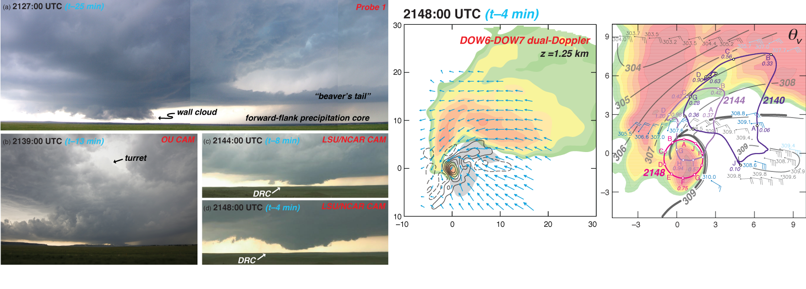

Our group’s observational research into the mysteries of tornadogenesis has involved extensive analysis of datasets from the Second Verification of the Origins of Rotation in Tornadoes Experiment (VORTEX2). This work has heavily relied upon mobile mesonet and Sticknet observations, dual-Doppler observations from the Doppler On Wheels and SMART radars, and photogrammetric observations. This work has been made possible through the generous support of grants from the National Science Foundation, as well as collaborations with the Center for Severe Weather Research and National Severe Storms Laboratory. See Markowski et al. (2012, Monthly Weather Review) and Markowski et al. (2018, Monthly Weather Review) and for more details.
More recently, we have flown pseudo-Lagrangian drifters through supercell storms in order to measure the 3D thermodynamic fields (buoyancy and buoyancy gradients in particular). Elissa Bartos is leading this effort. You can read more about it in this Bulletin of the American Meteorological Society article.


Dylan Steinkruger has been using machine-learning techniques to improve the tornado warnings in severe thunderstorms that lack the classic radar signatures routinely relied upon by forecasters for warning issuance. Such “nonclassical” severe storms are both dangerous to the public and particularly challenging for forecasters. The results thus far are extremely encouraging. Dylan’s automated algorithm has shown an ability to predict where tornadoes potentially could develop, up to 20 minutes in advance, within computer-generated nonclassical storms. Later work will examine actual nonclassical storms and will have to demonstrate similar skill while relying on radar observations.
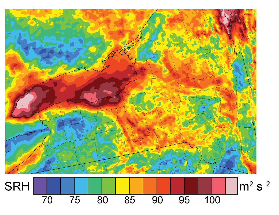
Relatively little is known about how topography affects convective storms. The first step toward understanding these effects is to investigate how topography affects storm environments. Unfortunately, the effects of topography on convective environments are not easily observed directly. In the image on the left, we show how data from NCEP’s High-Resolution Rapid Refresh (HRRR) can be used to expose how terrain effects storm environments. Mean 0–1-km storm-relative helicity is shown on convective storm days in New York state. Much of the variability is attributable to the influence of topography. This was the NOAA-funded M.S. research of Branden Katona. See Katona et al. (2016) for further details. Branden’s Ph.D. work explores how this terrain-induced environmental heterogeneity can influence storms.
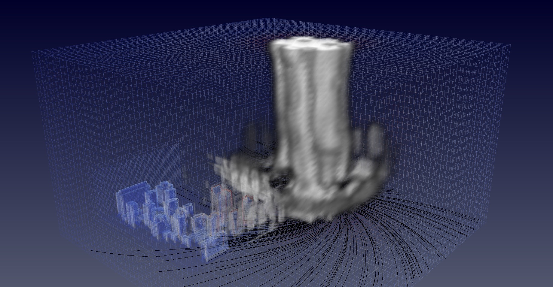
Dr. Val Jewtoukoff recently simulated tornadoes and explored how they are influenced by small-scale temperature perturbations, and more recently, buildings. This work was supported by the National Science Foundation.

Dr. Giovanni Jimenez studied the low-level jet in the Orinoco River Basin of Colombia, South America, for his Ph.D. (graduated in December, 2018). Here is one of his simulations of it. In addition to the wind speed maximum having a diurnal cycle (maximum at night), it also has a pronounced seasonal cycle (maximum in winter). The dynamics are interesting because they cannot be explained via the well-known Holton or Blackadar mechanisms. The work was published in the Journal of Geophysical Research.