Monthly Archives: July 2013

Fieldwork Blues

PSU Geography Japan

Penn State Geography, Japanese Alps

The hiking has been amazing.  Over the past two weeks Helena and I have been doing lots of hiking and though not all of it is far in distance (46km) there has also been a major elevation component (gain 5196, loss5246).  Each trip into the mountains begins with a roughly 1300m vertical assent over 4-6km.  So far Helena and I have made it to the top of 4 mountains (Tsubaroku, Jonen, Yokodoshidake, and Chogatake) in addition to a number of smaller hills and what felt like mountains in between.

Tsubakuro Peak

Peak of Tsubakuro

Chogatake Peak

Peak of Chogatake

Jonen Peak

Jonen Peak

Panorama_Yari_Tsubakuro

Panorama from near the Enzanso Hut on Tsubakuro

Presunset_Jonen_Yari

Pre-sunset from Jonen Peak across the Hotaka complex and Yari

The views from the peaks of these mountains and from the adjacent campgrounds have been amazing.  Our days are bookend by amazing sunrises at 4:45 and sunsets at 7:10.  However, we are not in the mountains to hike we are in the mountains to work.

Tsubakuro sunrise 3

Sunrise from our tent at Tsubakuro Enzanso Campground

Sunrise on Mountains

Sunrise Panorama from the campground at Tsubakuro Enzanso Hut.

Sunset_Jonen

Sunset from Jonen Goya (Hut)

Working in the mountains has had a number of false starts.  Initially we were limited in our work due to waiting on permits to come through.  Once the permits were all dotted and crossed we were able to begin working in the mountains, however, the leaves on the trees were not yet flushed.  Why is this important?  One of the aspects of my research is to examine the regeneration niche of seedlings throughout the forest and a key component is the light availability at ground level.  If the leaves have not fully opened (flushed) than there will be more light available than when the forest canopy is fully developed.  I am trying to measure the fully developed canopy light environment using hemispherical photography.

Norikura_flush

Snow on Norikura with birch leaves opening in the background, those in the foreground have yet to burst.

While waiting for the leaves to fully flush, Helena and I have headed to the mountains to assess the research sites and to core trees for the climate portion of my study.  Here, we have run into another problem, steep slopes.  While I knew some of my potential study sites would not be appropriate for my research, I did not expect the east slope of most mountains to be inappropriate.  When I say inappropriate it is not due to the species composition.  There are very nice forest belts from the sub-alpine forest, through the birch and up to the Haimatsu (creeping pine) belt.  These sites are inappropriate for they are too steep for safety.

Hiking in Haimatsu

Helena hiking through haimatsu

Jonen Poor

Poor east and west facing slopes at Jonen.

Most recently we hiked down what appeared to be a steep but not too steep slope on Chogatake, only to find that it was too steep.  Having climbed down from the Haimatsu belt to the Sub-alpine forest we realized that the slope was really a series of small cliffs and exposed meadows.  Hiking up the meadows was not feasible for there is no shrubs to hold onto so we climbed up the slope and small cliffs back to the top.  On a number of occasions we measured the steepness of the slope which was 60-70 degrees!  Thus the slope is too steep and not appropriate.  These slopes are hard enough to walk in let alone attempt to do field work.

Jonen to Chogatake

Jonen Peak towards Chogatake shows how steep the east (left side) is compared to the west (right side).

Chogatake Slope

Dangerously steep slope on Chogatake

Tsubakuro study sites

Tsubakuro Study area with the beautiful peak of Yari in the background

 All of this has led me to reassess and discuss my proposed fieldwork and how to continue to make progress towards completing my research, while doing it in a safe manner.

Tsubakuro

Overview of what you need to know to hike and camp on Tsubakuro.

TsubakuroView of Tsubakuro from Enzanso Hut

Distance wise Tsubakuro is probably one of the easiest mountains in the Northern Japanese Alps to climb.  From trail head to mountain top it is only 5.6 km, however, this distance does not include the knee cracking elevation gain that is included.  Across the 5.6 km distance of 1300m is gained, that is 3.5 miles with an elevation gain of 4,265 feet!  This climb took us 4 hours and 45 minutes with full packs (~45lbs, 20.5 kg).  According to the map this hike should take 4 hours with a moderate weight packpack.

Access:

Oito line train from Matsumoto to the Hotaka Station in Azumino City.  There are two ticket booths that are bilingual Japanese/English at the Matsumoto station; they are the two on the far left in Green.  Go to these booths to purchase your tickets.  If you want a round trip ticket select the round trip option, then Oito line and then select Hotaka.  The fee for a round trip ticket is 640 yen.  If you only want a one way ticket, you can select from a different menu the amount of yen to put onto your ticket, put 320 yen on your ticket for a one way fare.  Oito line trains run from platform 6/7, make sure you do not get onto the train for Shinshimashima (Kamikochi/Norikura).

From Hotaka station there are two options to access the trail head at Nakabusa Onsen.  Both options are operated by the Nan-an Taxi and Bus company.  Google translate does an ok job on the website though the pdf with the bus schedule is a bit out of whack when translated.  The first option is taking the bus.  As of 2013 the bus runs to and from the Nakabusa onsen 5 times a day from the Hotaka Station.  Bus fare is 1700 yen per person and takes roughly 55 minutes.  The second option is a Taxi.  This option is more expensive for one person, however, if there are four people it equals out to be the same as the bus. The taxi is 7300 yen, though divided by 4 it 1825.  When I took this option with some fellow backpackers the taxi driver dropped our fee down to 1700 yen to be comparable to the bus.  These two options are also available when returning from Tsubakuro going back to Hotaka Station.  Attached is an annotated version of the 2013 Nan-an bus schedule (Nan-an Bus schedule.pdf).

Trailhead:

At the trailhead there is a bathroom, water and a small shop.  Before heading into the mountains hikers are required to fill out a trail registration permit stating their route and expected time line.  This is all very confusing if like me you do not speak Japanese.  Lucky, on the train to Hotaka we met a niche Japanese couple who were also hiking Tsubakuro and helped me fill out the form.  This is what the form looks like and what you should fill out.

Trailhead Registration1Trailhead Registration2

How to fill out the Trail Registration Form

Trail:

Tsubakuro_GoogleEarth

Map of Trail from Trailhead at Nakabaso Onsen to Tsubakuro Peak.  There are 5 rest benches (only 4 on map) and two cabins along the way (GoogleEarth, 2013).

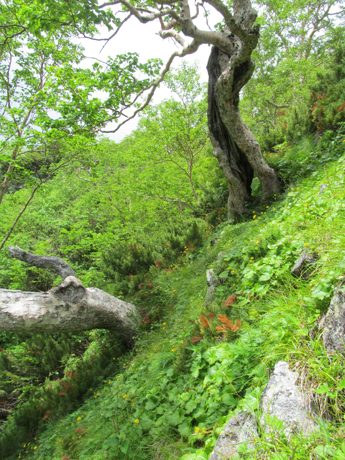
After filling up one last time with water you are now ready to hit the trail. Once on the trail you realize very quickly that it is going to be a long hard trudge up the mountain.  Along the trail there are 5 distinct resting benches and two cabins to help the weary hiker recuperate. At each bench it is a good idea to take a rest, snack and sip of water.  The trail up Tsubakuro is very steep so resting frequently and keeping hydrated will help fight altitude sickness.  If you are an obvious foreigner like me than at each of these stops you will be stared at by your fellow hikers.  Yes, fellow hikers.  Tsubakuro due to it’s ease and proximity to Matsumoto has many hikers.  You might even see entire schools hiking the mountain in matching uniforms.  Additionally, it is customary to say Konichiwa to everyone you pass.

Tsubakuro Trail 1

There are lots of uneven stairs to climb up

Tsubakuro Trail 2

Some of the stairs are just steps worn into the granite due to thousands of footsteps.

Tsubakuro Trail 3

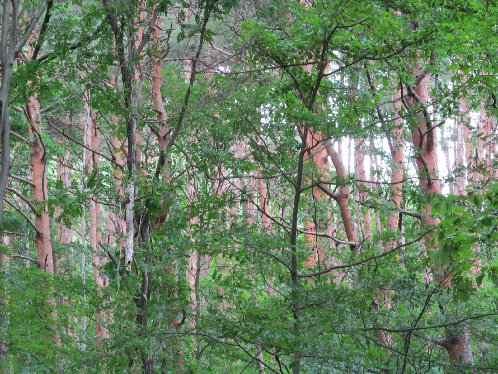
Other areas run the ridge lines surrounded by forest

Tsubakuro Trail 4

Scrambling up and down boulders

The first cabin is at the top of a cargo gondola where there is a free bathroom (or at least I did not see a sign asking for a fee) and a shop where you can buy food.  In addition to a bowl of udon or other classic hiking lodge foods you can also buy fresh fruit at this cabin.  Specifically, you can buy a giant slice of watermelon (800 yen) or Pineapple (400 yen).  After this cabin there is one more bench before reaching Enzanso.  Enzanso is one of the oldest hiking cabins still in use in the Northern Japanese Alps built in 1921.  It can hold lots of people in its rooms and dormitories as well as it appears to feed people in shifts, the exact number of people is not clear to me from their website. I think it says that 600 people can stay in the the cabin.

Enzanso Hut

Tsubakuro with the Enzanso hut and camping area

Enzanso also caters to the camping sorts and has room for roughly 40 tents on rock and snow patches.  If you are camping (as we were) you go inside the main entrance of the lodge and ask for “Tent” or look for the sign “テント” and tell them how many people and how many tents.  The fee for this was a little confusing it is either 500 yen per tent per night or 500 yen per person.  We stayed up on Tsubakuro for 3 nights, paying for the first two nights at the rate of 500 yen per tent, and the last night at 500 yen per person.  Either way it is not bad.  Included in the camping fee is use of the bathroom in the camping area.  It is important to note that you must provide your own toilet paper for the bathroom and soiled toilet paper is put into a trash can next to the toilet not in it.

 Tsubakuro Camping

Our tent is the small grey tent in the upper right portion of the snowbank.

Tent site selection is nothing like it is in the US where each group selects a site with a picnic table and room for one or two tents.  Camping in the mountains is a jigsaw puzzle, where pieces are fit together based on size, flatness and whether a spot is snowy or not.  Also unlike the US camping fills up fast.  We showed up at Enzanso around 2 pm to find the camping area almost completely full.  Granted it was on a holiday weekend (Umi no Hi) so more than the usual number of people were out in the mountains.  Thus if you are planning on camping try to arrive early to set up your tent or you will end up like us on our first night out on a precarious spot on a lumpy snow bank.

Lastly and possibly most important when hiking in the Japanese Alps is water.  At Enzanso to fill up a one litre water bottle costs 200 yen, that is roughly $2 to fill up your Nalgene in the mountains.  However, you have to consider how they get this water on the mountain tops.  It comes either snow melt, roof runoff, or pumped out of the ground so not the easiest or cheapest thing to collect.  It is well worth buying the water instead of hauling it up the 1300 vertical meters to the campground.

Scenery:

From Enzanso up to the peak of Tsubakuro is only one km.  Thus if you are just passing through it is worth dropping your pack at the lodge and running up the peak.  Make sure you bring your camera for the amazing views if sunny and flowers if sunny or foggy.  Enzanso and Tsubakuro are well known for its amazing views of Yari and sunrise when the weather is right.  If you are lucky you may see a troop of Japanese Macaque (Macaca fuscata) as well.

Yari TsubakuroYari is the pointed mountain in the background, visible on a rare clear day.

Tsubakuro sunrise 3

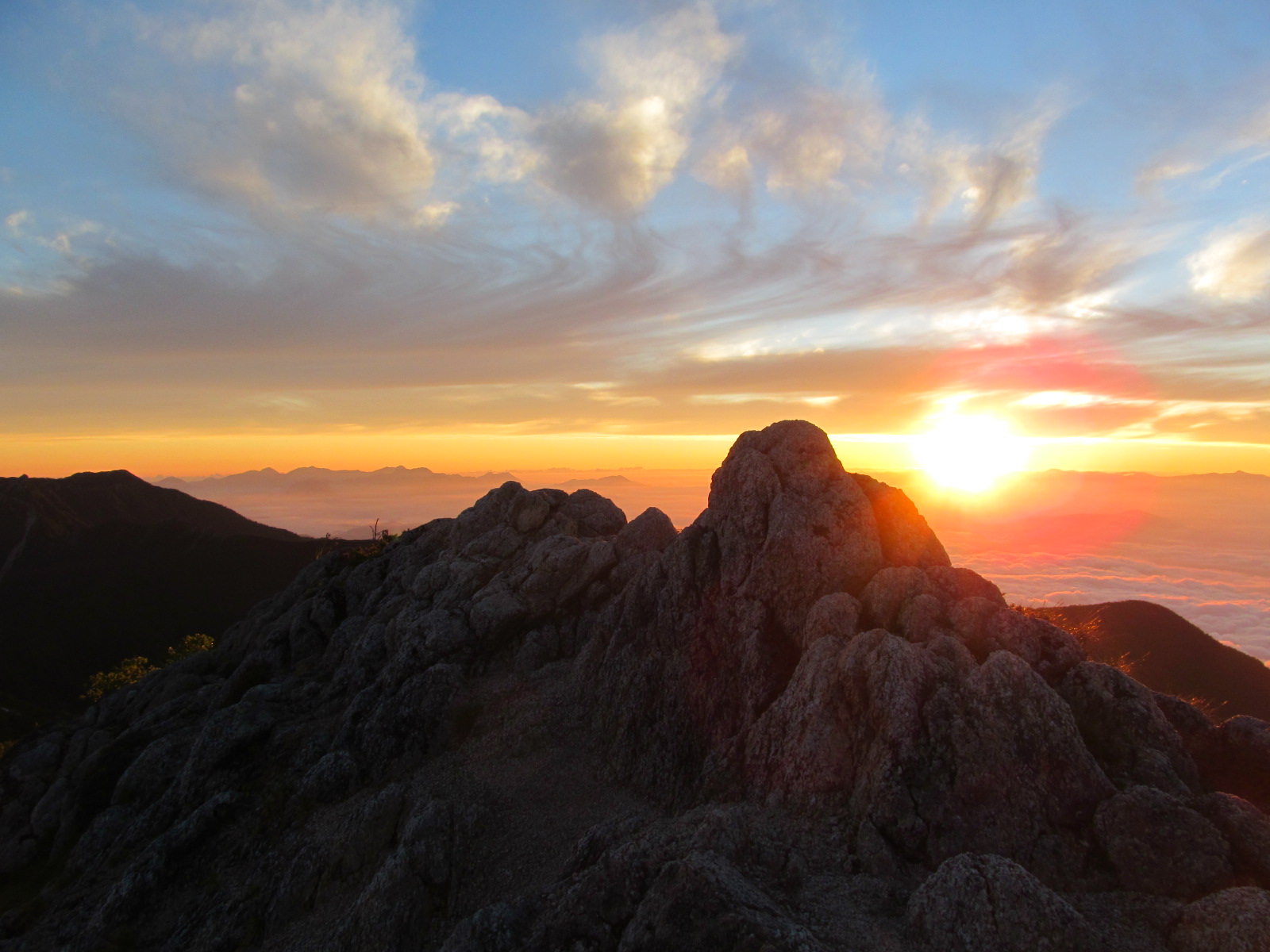
Sunrise over Matsumoto valley from Tsubakuro

Tsubakuro sunrise 2

Sunrise view from the door of the tent.

Tsubakuro Flowers1

Mountains, flowers and clouds.

Tsubakuro DicentraDicentra peregrina with Yari

Tsubakuro MonkeyJapanese Macaque (Snow Monkey) hanging out in the forest

The way back down from Tsubakuro to the trailhead is more painful in my view than the way up.  A constant knee pounding experience for 4.5 km leaves you feeling like a marionette puppet controlled by someone else when you reach the bottom.  Again on the way down there are the benches and the cabin with the watermelon to rest and recuperate at.

If you are traveling by bus back to Hotaka Station, keep in mind that the last bus is at 4pm.

Enzanso Hut Map

Using the rose shaped mountain map at the Enzanso hut to point out Yari.

Permits

In preparing for the field season one of the main tasks has been to navigate the Japanese Government Permit system.  Due to my limited abilities in Japanese I am very fortunate to be working with Dr. Koichi Takahashi of Shinshu University who has done the lion’s share of the permitting process.

My main task in this was to determine which mountains I would like to conduct my research and where on the mountain the study sites would be located.  To do this I conducted a site selection in Arc GIS limiting the area within Chubu Sangaku National Park to areas between 2200-2700m, less than 40 degrees slope and by dominant geological stratum (Granitic or Volcanic).  Using this method I narrowed down the potential study sites within the park down. However, I had never been to these mountains so I was not sure if they actually had the forest structures that I have proposed to study.  Using Google Earth, Bing, etc. satellite imagery I tried to examine these mountains to determine if they were appropriate.  However, the imagery for the mountains is nearly always during the winter, thus the hiamatsu (creeping pine) is covered with a thick layer of snow and the kaba (birch) is hard to detect.  After discussing the potential mountain study sites we settled on nine mountains to propose for the research.

Map of Study Mountains.jpg

Map of the nine mountains in Chubu Sangaku National Park/ Northern Alps

Once the mountains were determined the waiting from my side began, while Dr. Takahashi completed the permits form for each of the mountains.  In this process the exact site needs to be located on a map with a photograph of the proposed area.  Additionally, the amount of soils and tree cores to be sampled needs to be clearly stated.

Permits are first submitted to the prefecture Ministry of Environment, in my case I am working in three different prefectures (Nagano, Gifu and Toyama) so permits were sent to each one for the mountains within their borders.  Once the permits have been cleared by the prefectures they are sent on to the National Ministry of Environment.   Permits are then sent to Ministry of Forestry for approval, in highly protected areas, such as those in the Kamikochi area permits need to also be approved by the Ministry of Culture. The permits are returned to the applicant after each ministry has approved or declined the permit and the applicant then sends them to the next ministry. This whole system has seemed to be a large bureaucratic black box to me; however, I know there are many steps to getting an approved permit to do research in American national parks as well.  The difference I think is that both the culture and language are different here, both which typically leave me in a confused state.

After the first full week in Japan I have about 3/4 of the permits with prospects of having the Ministry of Culture permits by the end of July.  Currently I have enough permits to begin working without worrying about the last few for the time being. Things are looking up and the fact that I can write this means the black box is turning grey.

Jaunt to Misuzu Lake

Jaunt to Lake Misuzo

Today we took a morning walk up to Lake Misuzu just outside of Matsumoto.  Lake Misuzu is located in the foothill to the northeast of Matsumoto, to reach the road that goes to the lake we wandered around fields for rice and through a vineyard and had an amazing view of Matsumoto before heading into the forest.  From this point forward the road lead upward 486.2m upward to be exact.

Mapsource_LakeMisuzu.JPG

Map with our GPS tracks (14.5 km) showing the road up to Lake Misuzu from the International Student House (MapSource, 2013). 

View of Matsumoto

Matsumoto City from up at the hill before heading into the Mountains

Mapsource_LakeMisuzu_Profile.JPG

Vertical Profile from the International Student Housing to Lake Misuzu, Nagano Prefecture (MapSource, 2013).

Along the way we passed through a beautiful mixed forest of cedar, pine, Sugi (Cryptomeria japonica), chestnut, oaks and many other species that I could not identify.

 Sugi

Sugi (Cryptomeria japonica) looks a bit like redwood and sequoia but with a cypress like cone.

 Sugi Trees

Sugi Trees

PinePlantation

Some kind plantation pine tree it had two needles and small cones like jack pine or lodgepole pine, however the color and stem of the trees was very different

Hardwoods

Not exactly sure what type of hardwood this is but it was very pretty.

Though it was hot there was a nice breeze that would greet us as we turned around hairpin turns in the road, refreshing us for the climb.  When we arrived at the top of the hill saw a number of Japanese campers or day trippers playing croquet through the woods.  This is croquet like none other, they had mettle clubs and there was an established course with tees and said how many hits was par.

Croquet

Boy on the map playing croquet to show where the course runs.

After passing the croquet course we went downhill for about ½ a kilometer to Lake Misuzu.  It is a pretty reservoir with a lodge where you can rent swan shaped paddle boats and go fishing.  While there we relaxed in the shade and watched the large jumping fish and hawks circling around as we refreshed ourselves with snacks and water.

Misuzu lake

Lake Misuzu from the southwest shore looking across towards the dam.

Hawk at Misuzu LakeHawk at Misuzu Lake

On our way back down the hill we had another great view of the northern portion of Matsumoto with some of the Japanese Alps in the background.  Seeing the mountains makes us excited for the research that is about to begin.  In addition to a good view of town we also spotted a Japanese Serow (Capricornis crispus) or Nihon kamoshika (ニホンカモシカ)in Japanese standing above an erosion control cement slab.  The serow watched us as we watched it for about 5 minutes before it decided to wander off, but not before we took many photos of its deer/goat/antelope like figure.

NorthernMatsumoto

View of northern Matsumoto and the Japanese Alps on our way down the hill.

Japanese Serow1Japanese Serow2

Japanese Serow eyeing us up before wander off into the woods.

Overall Review:

This was a great and convenient walk/hike to get out of Matsumoto and into the woods.

Returning to Japan

My return to Japan has been full of apprehension and excitement.  Apprehension due to my return trip, second trip to Japan is the real deal.  Last summer was the pilot study to the dissertation; this summer so much more is on the line.  Due to the pressure of succeeding this summer I am nervous about both logistics and how the research will go.  Will everything work out perfectly, probably not, however, keeping the mishaps and delays to a minimum would be delightful.

Detroit Airport

Detroit Airport, our plane in the background of this fabulous fountain.

Not one of my apprehensions but still a concern for my return trip to Japan is that this year I have brought a research assistant (Helena Kotala).  Helena has recently graduated with a degree in Geography from Penn State and has spent the past year working as an intern in Dr. Alan Taylor’s Vegetation Dynamics Lab.  Helena is a competent hard worker and experienced in travel abroad, however I still feel responsible and nervous about guiding her through a country where I am still a newbie.

Helena with Matsumoto Castle

Meet Helena.

During our first few days in Japan traveling from Narita Airport to Matsumoto with a heavy case of Jetlag I was nervous and excited.  Nervous about finding the appropriate buses and ordering food, excited about being able to share this amazing experience and tell Helena all about Japan.  The more I explained about Japan the more I realized how much I have learned over the past year about the Japanese language and culture.

Map_Narita_Matsumoto.JPG

Map showing the route from Narita Airport (Green) to the east of Tokyo to Matsumoto (Red) in central Japan (Google Earth, 2013).

While traveling from Tokyo to Matsumoto the ticket agents spoke to at least some degree English, however, here in Matsumoto we are no longer interacting with ticket agents but with apartment caretakers, grocery store clerks and restaurant owners, and their English has been minimal to none.  Thus my minimal, though constantly improving Japanese has had to suffice. Some conversations go well, others I have no clue what is going on in.  But we have successfully moved into our apartments, kept fed and have even successfully purchased quadrangle maps for the mountains.

Giant_Sandals

 A pair of gigantic shoes at the Doso-jin temple in Azumino City (next to Matsumoto)

Wasbi Icecream

Yummmm.. Wasabi ice cream.  Helena agrees it tastes much better than expected, it does not give you the sensation of nasal fire but tastes more plant-like

During the first few days in Matsumoto, Helena and I worked on recovery from Jet lag as tourists.  With the uncertainty of what the summer will bring inspired us to visit the “must see” site in and around Matsumoto in case later in the summer time ran short.  Through this we retraced many of my steps from last summer visiting Matsumoto Castle, walking down tiny roads to be surprised by a temple or shrine as well as visiting the Daiso Wasabi farm.  Through all of these activities I imparted both useful and random facts about the locations and what people were doing as well as teaching Helena some basic Japanese.  She is now a perfectly polite foreigner saying kudasai (please), arigatoo gozaimas (thankyou), sumimasen (excuse me) and konnichiwa (hello).

It is fun to share and teach about life in Matsumoto, but I cannot wait to share the mountains.

Wasabi

Wasabi at the Daiso Wasabi Farm