(Click on the following link to listen to an audio version of this blog …. Colorado Plateau )
We leave Glenwood Canyon and follow the Colorado River out of the mountains. We are now in the province of the Colorado Plateau.
The Colorado Plateau is a vast region (130,000 square miles) dominated by sedimentary rock. The Plateau has repeatedly, over hundreds of millions of years, en masse, risen up many thousands of feet and then eroded back down most of those feet. Amazingly, these rises and falls have occurred with little or no deformation in the Plateau’s rock layers. Compared to the nearby Rocky Mountain and Basin and Range provinces, the rock strata of Colorado Plateau just seem to bob up and down in geological time with little bending, folding or twisting. Layer after layer of sandstone, mostly tinted red from iron oxides but each distinctly colored and textured with their own base minerals and unique origin stories, lie flat on top of each other like layers of a vast, geological cake.
The geologist Charles Dutton writing about this area back in 1885 noted that there seemed to be
“many short, abrupt ranges, or ridges, looking upon the map like an army of caterpillars crawling northward. At length, about 150 miles north of the Mexican boundary, this army divides into two columns, one marching northwest, the other northeast … This split in the main chain of cordilleras, forming the Basin and Range on the west and the Rockies on the east leaves between them the vast area of the Plateau country.”
The Colorado Plateau is roughly centered over the Four Corners region where the respective corner-angles of Colorado, New Mexico, Utah and Arizona come together. It is bounded by the Rocky Mountains to the northeast, the Rio Grande Rift to the southeast, the Mogollon Rim escarpment to the south and the Basin and Range province to the west. Ninety percent of the Colorado Plateau is drained by the Colorado River while the rest is drained by the Rio Grande.
The Plateau is covered mostly with sparse, desert and dry-steppe vegetation with scattered stands of pinyon pine (Pinus edulis) and juniper (Juniperus osteosperma) and montane forests of ponderosa pine (P. ponderosa) in the south and lodgepole pine (P. contorta var. latifolia) and quaking aspen (Populus tremuloides) in the north. Forests are found in sites that are positioned to more efficiently gather or retain the scant moisture delivered by winter snows and rare summer rains. On average the Plateau receives between 6 and 16 inches of precipitation a year with higher elevations gathering the higher amounts of rain and snow. In recent years, however, these “average” annual moisture levels have been only rarely met.
The erosion that wears down these layers of sandstone is powered by water, ice and wind. Countering this downward erosion, though, is a tectonic uplifting of the Plateau (driven most recently by the lateral, underthrust of the Farallon Plate which also lifted the Rocky Mountains 65 million years ago) and also by an isostatic, upward rebound of the rock as the weight of thousands of feet of surface materials are eroded away. The Colorado River and its tributaries cut deeply into these rising rock layers and have carved the magnificent canyons and vistas seen in Canyonlands National Park, Glen Canyon and the Grand Canyon.
Adding to the complexities and possibilities of the Plateau, under the layers of rock is a 300 million year old salt bed that is thousands of feet thick. A relic of an ancient, evaporated ocean, this salt layer has been compressed by the overlying rocks that at one time were, possibly, a mile thick. Under the pressure of these rocks, the salt became fluid and flowed, shifted and buckled causing the rocks above it to fracture and crack in very unique ways. These cracks led to the long sets of narrow masses of surface stone called “fins”
and numerous, narrow slot canyons that are seen throughout the Plateau. The erosion of the fins (primarily by water and ice) then led to the formation of the natural bridges, arches, hoodoos and hanging rocks that make the Plateau landscape so surreal and unique.
Attesting to the uniqueness of the Colorado Plateau are the large number of sites within it that have been set aside for preservation. There are nine National Parks (including Grand Canyon, Zion, Arches, Canyonlands, Bryce Canyon and Mesa Verde) and eighteen National Monuments (including Bear’s Ears, Dinosaur, Chaco Canyon, Natural Bridges and Canyon of the Ancients) within the boundaries of the Colorado Plateau. There are more “national” designation sites on the Colorado Plateau than in any other place in the country outside of Washington, D.C..
Arches National Park sits on top of a very active part of the underlying salt bed. Its surface sandstone layers have been extensively moved about and cracked by deep shifts in the salt. This has generated many sets of fins that then have been spectacularly eroded. A good place to see fins up-close in the park is at the start of the Landscape Arch trail. As the trail leaves the parking area it runs between two tall, relatively intact, Entrada sandstone fins. The trail space between the fins is shady and cool and the facing rocks are extensively covered with lichens.
If you look back after walking through the gap between these fins, you can see that one side of each fin (the northeast) is slightly concave while the other (the southwest) is flat or, in places, even slightly bowed outward. Water, and snow and ice have started to work on the northeast faces of the fins scratching away the stone’s sand grains. On the more sheltered side of the fin, though, this erosion has occurred more slowly if at all.
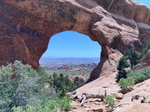
This gentle wearing away of the exposed face of a fin will eventually work its way deeper and deeper into the sandstone face. Shallow holes are formed which, as they pool more water and hold more and more ice, then begin to erode more rapidly. Small pits expand into deeper holes and then, after a great span of time, a hole might even extend all the way through to the other face of the fin making a “window.” These windows then expand and, if the rock is strong enough, a bridge or an arch may result. If the rock is not strong enough, the whole rock fin collapses into a pile of sand and stony debris. Even if the rock is strong, though, the bridge or arch is a temporary thing and will, eventually, collapse into a pile of debris. Erosion always wins!
The number and diversity of arches, bridges and windows across the terrain of Arches National Park is unmatched by any other place in the world. There are, according to the National Park Service, over 2000 cataloged arches in the park! The landscape is unique, dream-like and unforgettable. The underlying salt bed must have been incredibly active to generate all of the cracks in the overlying sandstone. The sand grains in the fin sandstones, in turn, must have been lightly held together to allow the extensive erosion of the stone that then generated the incredible number of holes and windows visible across Arches. The innate strength of these eroding rocks, though, to then hold the crumbling stone together in fragile arches and bridges must have been a uniquely balanced set of innate characteristics. Arches National Park is like no other place on Earth.
In 1956 and 1957, Edward Abby worked as a park ranger at Arches National Monument (which became Arches National Park in 1971). He wrote about some of his experiences in and around Arches in his 1968 book Desert Solitaire. Here are two passages about arches:
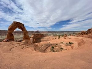
“There are incredibly pious Midwesterners who climb a mile and a half under the desert sun to view Delicate Arch and find only God, and the equally inevitable student of geology who look at the arch and see only Lyell and the uniformity of nature. You may find proof for or against His existence. Suit yourself.’
“If Delicate Arch has any significance it lies, I will venture, in the power of the odd and unexpected to startle the senses and surprise the mind out of ruts of habit, to compel us into a reawakened awareness of the wonderful – that which is full of wonder,”
I have a notebook full of quotes from Desert Solitaire. It is one of my favorite books. I highly recommend it!
We spent two days hiking in Arches and saw sculpted and molded masses of rock that defied our imaginations! It was wonderful, truly a place full of wonder!
(Next week: sagebrush!)


