31
Mar 15

Coffee Hour with Rinku Chowdhury | 2 degrees, “utterly inadequate” | AAG news

IMAGE OF THE WEEK

Old Main at dawn

Old Main at dawn. Photo by Angela Rogers

GOOD NEWS

MGIS student Roger Bannister, with Patrick Kennelly as coauthor, has recently published his capstone work as “Incorporating Stream Features into Groundwater Contouring Tools Within GIS” in the journal Groundwater.

Sterling Quinn was accepted to the summer doctoral program at the Oxford Internet Institute, to be held in July at Oxford University.

Sam Stehle successfully defended his dissertation proposal.

NEWS

Coffee Hour Rinku Chowdhury “The homogenization of (sub)urban America? A comparative approach”
Urban residential expansion increasingly drives global changes in land use and vegetative cover. At regional and local scales, residential land use and management are driven by diverse socio-ecological factors, yet may result in converging land cover outcomes in otherwise distinct eco-climatic regions. I draw on collaborative research focused on six US cities (Miami, Baltimore, Boston, Minneapolis, Phoenix, Los Angeles), to examine whether urbanization is associated with a homogenization of land/vegetative cover across distinct urban and climatic regions as well as sociodemographic neighborhoods.

2 degree Celsius climate change target “utterly inadequate”
The official global target of a 2-degree Celsius temperature rise is “utterly inadequate” for protecting those at most risk from climate change, says a lead author on the Intergovernmental Panel on Climate Change (IPCC), writing a commentary in the open access journal Climate Change Responses. Petra Tschakert, a coordinating lead author of the IPCC’s Fifth Assessment Report, says: “The consensus that transpired during this session was that a 2-degree Celsius danger level seemed utterly inadequate given the already observed impacts on ecosystems, food, livelihoods, and sustainable development.

Alumni and Friends Reception during AAG
The Department of Geography will hold a reception on April 23, from 7:00 to 9:00 p.m. during the AAG annual meeting in Chicago. For more information and to sign-up: http://www.geog.psu.edu/aag-reception

Zelinsky and Matthews’s book “The Place of Religion in Chicago” inspires
field trip
during AAG
The “Sacred Places in Chicago” field trip is sponsored by the Geography of Religions and Belief Systems Specialty Group and will be led by Richard N. Dodge, of the Desert Rose Baha’I Institute in Eloy Arizona. The trip is from 9:00 a.m. to 2:30 p.m. Thursday, April 23, 2015, leaving from the conference hotel by bus).  Dodge said The Place of Religion in Chicago done by Stephen Matthews and the late Wilbur Zelinsky is a valuable reference for the field trip and a paper he is giving at the AAG annual meeting.
Field trip information: http://www.aag.org/cs/annualmeeting/schedule_and_program/field_trips_workshops/field_trips

Participants wanted for a geovisual analytics web app usability study
Participants will be asked to become familiar with a web application, and later be asked to answer task oriented multiple choice questions with the aid of the application. A portion of the study can be completed individually at anytime, and the other portion will take place on campus at University Park. This study will take 2 hours (1 hour off-site and 1 hour on-site). Participants will be given a $20 Amazon gift card. Must be over the age of 18. If you are interested, please contact Brian Swedberg: bws180@psu.edu by April 7

Students gain geographic ground following Esri software pledge to White House ConnectED Initiative
At the White House Science Fair, in conjunction with President Obama’s ConnectED Initiative, Esri announced significant academic progress from its billion-dollar commitment to offer mapping technology to every K-12 school in the United States. Since the program’s launch on May 27, 2014, more than 1,000 schools have grown their geographic programs through Esri’s ConnectED pledge. Eric Cromwell (MGIS ’11) is the elementary science coordinator for Baltimore County Public Schools, and has been using desktop GIS for a decade. On the heels of the May 27 announcement by the White House, Eric set about changing plans for the district.

DOG OF THE WEEK

Send your answer and/or a photo of your dog to geography@psu.edu for our mystery dog of the week!

dog

Who is this dog? Who is her human?


24
Mar 15

Coffee Hour with Budhendra Bhaduri | Penn Staters presenting at AAG | Research on contrails and weather

IMAGE OF THE WEEK

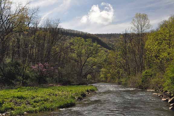
Spruce Creek in spring. By Rob Brooks

Spruce Creek in spring. By Rob Brooks. Send your photos from fieldwork and travel to geography@psu.edu to be featured as our image of the week

GOOD NEWS

Andrew Carleton and his students, Adrienne Tucker and Jase Bernhardt, attended the 95th Annual Meeting of the American Meteorological Society in Phoenix in January. Tucker won the Best Student Paper Award in the Conference on Planned and Inadvertent Weather Modification, and Bernhardt won the Best Student Paper Award in the History Symposium.

Ashlee Adams and Sara Cavallo each passed her masters thesis defense last week.

Sterling Quinn has been nominated for “2015 GeoForAll Global Educator of the Year Award” for his course: GEOG 585: Open Web Mapping.

Nari Senanayake passed her candidacy exams and also received the SSRC Dissertation Proposal Development Fellowship and the American Institute for Sri Lankan Studies’ Dissertation Planning Grant.

NEWS

Coffee Hour: Budhendra Bhaduri “Landscape Dynamics, Geographic Data and Scalable Computing: The Oak Ridge Experience”
Understanding change through visualization of landscape processes often provide the most effective tool for decision support. Current geoanalytics are limited in dealing with temporal dynamics that describe observed and/or predicted behaviors of entities i.e. physical and socioeconomic processes. End point based temporal analysis can capture events signified by broad changes in observable earth features; but are inadequate for revealing temporal characteristics of the processes as defined by the onset, frequency, and rate of changes in the features.

  • 3:30 to 5:00 p.m.
  • Refreshments are offered in 319 Walker Building at 3:30 p.m.
  • The lecture begins in 112 Walker Building at 4:00 p.m.
  • Coffee Hour To Go
  • Next Week: Rinku Chowdhury “The homogenization of (sub)urban America? A comparative approach”

Many Penn Staters presenting at the AAG annual meeting
More than 65 students (graduate and undergraduate), faculty, and staff from the Department of Geography are presenting at the AAG annual meeting in Chicago, Illinois, April 21–25, 2015. View a spreadsheet to see who’s presenting when and where.

RIT professor creates better maps for navigating disasters in
Syrian refugee camp

Geographic Information Systems used in NSF-funded project
Brian Tomaszewski (Ph.D. ’09) hopes to make riots, fires and sand storms a little easier to manage at the Zaatari Syrian refugee camp in Jordan. The assistant professor of information sciences and technologies at Rochester Institute of Technology spent a week of his winter break in Jordan, looking at how geographic information systems (GIS) and mapping can be used to mitigate potential emergency and disaster situations that threaten life at the refugee camp. The trip was part of a collaborative National Science Foundation (NSF)-funded project to examine the camp’s current infrastructure, look at ways to improve it and apply those ideas to other refugee camps.

Recently (or soon to be) published

Stehle, S., & Peuquet, D. J. (2014). “Analyzing Spatio-Temporal Patterns and Their Evolution via Sequence Alignment.” Spatial Cognition & Computation: (in press) Special issue on spatio-temporal theories and models for environmental, urban and social sciences: where do we stand?

“The impacts of long-lived jet contrail ‘outbreaks’ on surface station diurnal
temperature range”
By Jase Bernhardt and Andrew Carleton
In International Journal of Climatology doi:10.1002/joc.4303
Multiple persistent jet aviation contrails – contrail ‘outbreaks’ – occur frequently over certain portions of the Continental United States (CONUS). The artificial cloudiness generated by contrail outbreaks alters the atmospheric radiation budget, potentially impacting the surface air temperature, particularly the diurnal temperature range (DTR), or difference between daytime maximum and nighttime minimum temperatures. This study evaluates the hypothesis that contrail outbreaks reduce the DTR relative to clear-sky conditions. We utilize a database of longer-lived (>4 h duration) jet contrail outbreaks for the CONUS previously determined from interpretation of high-resolution satellite imagery, for the January and April months of 2008 and 2009.

DOG OF THE WEEK

Last week’s dog was Libby, companion to Arielle Hesse. Send a photo of your dog to geography@psu.edu for our mystery dog of the week!


16
Mar 15

Coffee Hour with Ken Kato | THON recap | New research on tweets

IMAGE OF THE WEEK

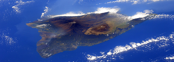
the island of Hawaii

From the International Space Station, European Space Agency astronaut Samantha Cristoforetti took this photograph of the island of Hawaii on Feb. 28, 2015. Image Credit: NASA/ESA/Samantha Cristoforetti

GOOD NEWS

Aparna Parikh is the winner of this year’s SWIG Nancy Brown Geography Community Service Award.

Guido Cervone was awarded a PSIEE seed grant for the project: Solar BASES: New Solar Data Informing the Next Generation of Smart Energy Systems.

Three alumni — Reuben Rose-Redwood (M.S. ’02, Ph.D. ’06), John Krygier (Ph.D ’95), and Jeremy Crampton (M.S. ’87, Ph.D. ’94)— are among the authors of the forthcoming Cartographica special issue “Deconstructing the Map.”

Sterling Quinn has been nominated for “2015 GeoForAll Global Educator of the Year Award” for his course: GEOG 585: Open Web Mapping.


NEWS

Coffee Hour: Ken Kato “Advancing a campus GIS from a mapping system to a platform for exploring the spatially enabled smart city”

Alongside supporting faculty colleagues with research projects, an essential function of the InfoGraphics Lab is providing our campus with a GIS and mapping system. Delivering timely and accurate spatial information to those charged with delivering essential services that make the university run, producing accurate maps for wayfinding, and providing a rich experiential learning opportunity for our students has been pillar of our program.

EMS THON recap: an insider’s perspective
For the fifth year in a row, the EMS THON raised the largest amount among general organizations for The Four Diamonds, fighting pediatric cancer. Student dancers and committee members say the THON families and EMS THON esprit de corps are why they do it.

Behind the Relaunch of The New York Times Magazine
Our design director, Gail Bichler, on this week’s covers: “We asked several artists to make works based on the idea of chaos in the world, and how this is something we have all learned to live with. The only constraint we gave them was that they had to use imagery of the earth or a globe.”

Recently (or soon to be) published

“Review of remote sensing methodologies for pavement management and assessment”
Schnebele, B. F. Tanyu, G. Cervone and N. Waters
In European Transport Research Review
doi:10.1007/s12544-015-0156-6
Evaluating the condition of transportation infrastructure is an expensive, labor intensive, and time consuming process. Many traditional road evaluation methods utilize measurements taken in situ along with visual examinations and interpretations. The measurement of damage and deterioration is often qualitative and limited to point observations. Remote sensing techniques offer nondestructive methods for road condition assessment with large spatial coverage. These tools provide an opportunity for frequent, comprehensive, and quantitative surveys of transportation infrastructure.

“Geovisual Analytics Approach to Exploring Public Political Discourse on Twitter”
Jonathan K. Nelson, Sterling Quinn, Brian Swedberg, Wanghuan Chu and Alan M. MacEachren
In International Journal of Geo-Information
doi:10.3390/ijgi4010337
We introduce spatial patterns of Tweets visualization (SPoTvis), a web-based geovisual analytics tool for exploring messages on Twitter (or “tweets”) collected about political discourse, and illustrate the potential of the approach with a case study focused on a set of linked political events in the United States. In October 2013, the U.S. Congressional debate over the allocation of funds to the Patient Protection and Affordable Care Act (commonly known as the ACA or “Obamacare”) culminated in a 16-day government shutdown. Meanwhile the online health insurance marketplace related to the ACA was making a public debut hampered by performance and functionality problems. Messages on Twitter during this time period included sharply divided opinions about these events, with many people angry about the shutdown and others supporting the delay of the ACA implementation.

DOG OF THE WEEK

Send your answer and/or a photo of your dog to geography@psu.edu for our mystery dog of the week!

dog

Who is this dog? Who is her human?


02
Mar 15

No Coffee Hour due to Spring Break | The Knowledge | Research on UCD

IMAGE OF THE WEEK

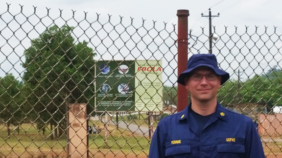
MGIS alumnus Stephen Perrine currently deployed as part of an Ebola Task force team in Liberia.

MGIS alumnus Stephen Perrine currently deployed as part of an Ebola Task force team in Liberia.

GOOD NEWS

  • Andrew Homka accepted a full time GIS Analyst Job offer with TerraSim in Pittsburgh, starting in late May.
  • Andrew Carleton is a co-author (with colleagues in France and Norway) on a recently-accepted article titled “Polar-low tracks over the Nordic Seas: A 14-winter climatic analysis.” The article will be published in the European/Swedish geophysical journal Tellus, Series A.
  • Peter Koby passed his doctoral comprehensive exams last week.

NEWS

No Coffee Hour March 6 or March 13 due to Spring Break

Malini Foundation Summer program
Last summer 11 Penn State students travelled to Sri Lanka on a cultural immersion and service-learning program organized by PSU alumna Valerie Handunge, founder of the Malini Foundation. Their lives were changed by the experience:  https://www.youtube.com/watch?v=PygxoH07WwY. The Global Fellows Program focuses on community development and the complex social and cultural issues impacting women and girls in developing countries like Sri Lanka. Through a two-week trip or a four-week internship, students are provided with real-world field experiences, interaction with thought leaders and social entrepreneurs, and multidisciplinary engagement, supplemented through an informed pre- and post-visit curriculum. We seek to provide students insights into the operations of large international non-profits as well as smaller grassroots organizations in Sri Lanka. Students may come from diverse academic backgrounds with two things in common – a passion for humanitarian causes and the desire to develop a global-minded, entrepreneurial perspective. There are a variety of ways to receiving funding for this experience. Please contact Sharmila Sandirasegarane at svs5568@psu.edu for further details and information on the programs and Foundation. To apply, please follow this link: http://goo.gl/forms/JlfrnbM9Hi. Applications are due on March 6.

The Knowledge, London’s Legendary Taxi-Driver Test, Puts Up a Fight in the Age of GPS
The examination to become a London cabby is possibly the most difficult test in the world — demanding years of study to memorize the labyrinthine city’s 25,000 streets and any business or landmark on them. As GPS and Uber imperil this tradition, is there an argument for learning as an end in itself?


Recently (or soon to be) published

Roth, Robert E.; Ross, Kevin S.; MacEachren, Alan M. 2015. “User-Centered Design for Interactive Maps: A Case Study in Crime Analysis.” ISPRS Int. J. Geo-Inf. 4, no. 1: 262-301. doi:10.3390/ijgi4010262

In this paper, we address the topic of user-centered design (UCD) for cartography, GIScience, and visual analytics. Interactive maps are ubiquitous in modern society, yet they often fail to “work” as they could or should. UCD describes the process of ensuring interface success—map-based or otherwise—by gathering input and feedback from target users throughout the design and development of the interface. We contribute to the expanding literature on UCD for interactive maps in two ways. First, we synthesize core concepts on UCD from cartography and related fields, as well as offer new ideas, in order to organize existing frameworks and recommendations regarding the UCD of interactive maps. Second, we report on a case study UCD process for GeoVISTA CrimeViz, an interactive and web-based mapping application supporting visual analytics of criminal activity in space and time.


Skip to toolbar