27
Oct 20

Filmmaker: our lives are inherently spatial | GIS Day is coming | Student paper published

IMAGE OF THE WEEK

fall color Rothrock

Alan Taylor share this image of fall colors in Rothrock State Forest, Bear Meadows and Thickhead Mountain in the background. Taken on horseback Oct. 17, 2020. Image: Alan Taylor

GOOD NEWS

MGIS student Nathaniel Geyer published his capstone paper in the International Journal of Geo-Information.

Alumnus Wayne Brew has published three photo essays in PAST, the online journal for the International Society for Landscape, Place and Material Culture. 

Esri Mid-Atlantic User Group will hold a one-day virtual meeting on Dec. 4, 2020. If you would like to submit a presentation for consideration, send an abstract of your topic and desired talk length (10 minutes lightning or 15-20 minutes traditional) to Sandra.Woiak@fairfaxcounty.gov by November 2.

COFFEE HOUR

Next Coffee Hour is November 6 with David Maune of Dewberry Engineers, Inc.
Mapping and Surveying Alaska – America’s Last Frontier

NEWS

Penn State GIS Day virtual event to take place Nov. 12

Penn State University Libraries will observe GIS Day — an annual event celebrating the technology of geographic information systems (GIS) — with a virtual event from 4 to 5 p.m. on Thursday, Nov. 12.

Penn State GIS Day brings together those who work with GIS, geospatial technologies, remote sensing, maps, and location-based research to foster greater geospatial awareness throughout the University, within the community, and beyond. Both new and experienced users of geospatial information across disciplines are encouraged to participate.

Penn State alumna reflects on how geography influences her filmmaking

If you have viewed short documentary films about the 19th amendment on The New York Times website or national monuments on The Washington Post website this year, you have seen the work of Penn State alumna Megan Ruffe, a Schreyer Scholar who graduated in 2013, earning degrees in film production and geography.

Now based in Brooklyn, New York, Ruffe is a co-producer at Florentine Films, Ken Burns’ documentary company.

RECENTLY PUBLISHED

LionVu 2.0 Usability Assessment for Pennsylvania, United States

Geyer, Nathaniel R., Kessler, Fritz C., Lengerich, Eugene J.
International Journal of Geo-Information
https://doi.org/10.3390/ijgi9110619
The Penn State Cancer Initiative implemented LionVu 1.0 (Penn State University, United States) in 2017 as a web-based mapping tool to educate and inform public health professionals about the cancer burden in Pennsylvania and 28 counties in central Pennsylvania, locally known as the catchment area. The purpose of its improvement, LionVu 2.0, was to assist investigators answer person–place–time questions related to cancer and its risk factors by examining several data variables simultaneously. The primary objective of this study was to conduct a usability assessment of a prototype of LionVu 2.0 which included area- and point-based data. The assessment was conducted through an online survey; 10 individuals, most of whom had a masters or doctorate degree, completed the survey. Although most participants had a favorable view of LionVu 2.0, many had little to no experience with web mapping. Therefore, it was not surprising to learn that participants wanted short 10–15-minute training videos to be available with future releases, and a simplified user-interface that removes advanced functionality. One unexpected finding was the suggestion of using LionVu 2.0 for teaching and grant proposals. The usability study of the prototype of LionVu 2.0 provided important feedback for its future development.


20
Oct 20

Coffee Hour with Debanuj DasGupta | Mapping glacial algae | GEOGRAPH highlights grad students

IMAGE OF THE WEEK

mug shot2

The “mug shot” of speaker Garrett Graddy-Lovelace taken at the end of the October 9 Coffee Hour.  Videos of Coffee Hour lectures are available on The Coffee Hour media channel.  And this Friday at 4 p.m., our Coffee Hour speaker is Debanuj DasGupta.

GOOD NEWS

The video of the October 13 Information Session on Graduate Programs in Geography is available on YouTube.

Gamma Theta Upsilon (GTU), the geography honor society, will hold an induction ceremony on Monday, Oct. 26, at 7:30 pm.

Penn State GIS Day will be held virtually on Thursday, November 12.

AAG is extending its paper abstract submission deadline to November 19, 2020, and also giving Annual Meeting participants more time to register at the current fee levels.

COFFEE HOUR

Coffee Hour with Debanuj DasGupta
Queering Geopolitics/Queering Pandemic

Geopolitics can be understood as an analytical category simultaneously for approaching the contemporary world order, as well as to interrogate sexuality and gender identity as it is produced through/with statecraft, and in the striving of sexually marginalized communities to create bodily security. Global governance, international human rights principles have failed to protect transgender cross border migrants. Simultaneously, the present epidemiological initiatives around the COVID-19 pandemic is yet to fully address the impact of the pandemic upon the lives of LGBTQ communities. The containment and prevention of the virus requires spatial strategies such as sheltering, social distancing, and physical isolation. Transgender communities experience physical isolation and unsafety on an everyday basis in home, work, and public spaces. Spatial strategies for containing the virus have created additional burdens on diverse transgender communities globally.

NEWS

Ocean color satellites reveal glacier algae, insights for climate models

The brownish-grey algae that darken the Greenland ice sheet in summer cause the ice to melt faster, but only recently have scientists measured these blooms in the field, and only at few sites. To measure algal blooms across large regions and understand their effects on melting over time, scientists are now turning to space.

GEOGRAPH highlights

If you missed your printed copy of GEOGRAPH annual newsletter, articles are being added to the department website, and a downloadable PDF is available now. This week’s highlights:

Graduate students emphasize relationships:

World Campus graduate, reservist wins award for geospatial intelligence

RECENTLY PUBLISHED

Probabilistic forecasting using deep generative models

Alessandro Fanfarillo, Behrooz Roozitalab, Weiming Hu and Guido Cervone
Geoinformatica
https://doi.org/10.1007/s10707-020-00425-8
A fundamental problem in Numerical Weather Prediction (NWP) is the generation of ensembles to capture the probability of future states of the atmosphere. This research presents a new methodology to generate analogs using deep generative models, an emerging class of deep learning approaches. The goal is to train a deep generative model using a set of historical forecasts and associated observations, and to use it to entirely or partially replace the need to maintain a potentially very large dataset. In this research, this new methodology is compared with the Analog Ensemble (AnEn) approach, a computationally efficient solution to generate analogs. The proposed approach promises to reduce the amount of memory required to produce the probabilistic forecast by several orders of magnitude. Results show that the generative model solution is constant time without performing any search, saving a considerable amount of time even in the presence of huge historical datasets.


13
Oct 20

Grad Admission Info Session today | GEOGRAPH highlights

IMAGE OF THE WEEK

arboretum

Leaves are changing color in this live image capture from the Penn State Arboretum webcam.

GOOD NEWS

TODAY Oct. 13, 4 p.m.:  Information session on graduate program admissions

Oct. 15, noon: Brownbag session on research in the era of COVID-19

AAG Careers and Professional Development Webinar Series  This fall the AAG will pilot two new webinar series as a service to AAG members and the wider geography community. Although the topics focus on issues for geographers navigating their early careers and geography leadership building and growing strong academic programs, these subjects can be insightful for everyone.

COFFEE HOUR

Next Coffee Hour is October 23 with Debanuj DasGupta
Queering Geopolitics/Queering Pandemic

NEWS

GEOGRAPH highlights

If you missed your printed copy of GEOGRAPH annual newsletter, articles are being added to the department website, and a downloadable PDF is available now. This week’s highlights:

From the Head of the Department: Spilling forward to a new kind of fall

Recognition Reception revamp

Award-winning undergraduates: Get involved, challenge yourself


06
Oct 20

Coffee Hour with Garrett Graddy-Lovelace | Fracking bill study | Wine atlas

IMAGE OF THE WEEK

cluster map
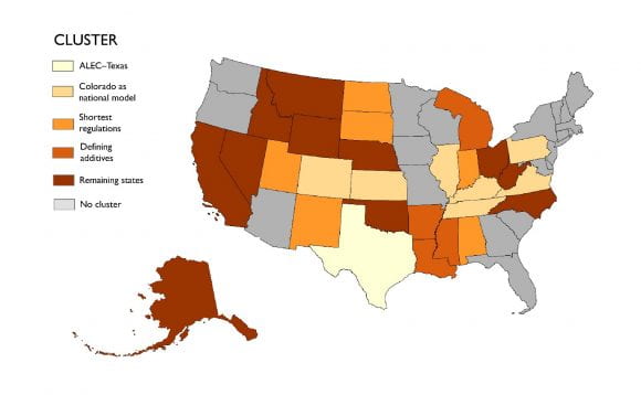
A five-cluster analysis, with groupings that best matched the manual review of the regulations, was used to qualitatively discern patterns across the states, in the study, “Disclosing Influence: Hydraulic fracturing, interest groups, and state policy processes in the United States,” led by Jenn Baka. Map: Harrison Cole

GOOD NEWS

Alumnus Sid Pandey, who graduated in 2014, was selected as a member of URISA’s Vanguard Cabinet for their 2021–23 cohort.

Alumnus Martin von Wyss, who graduated in 1994, has launched World Wine Regions, worldwineregions.com, an interactive atlas of the world’s wine regions.

Call for Presentations: The 2021 Education Summit @ Esri UC will highlight presentations showing how GIS is being used in education to connect people together and shape our future. The deadline to submit a proposal for your presentation is Oct. 30, 2020.

American Geographic Society September 2020 Newsletter is available.

Upcoming activities in the Department of Geography
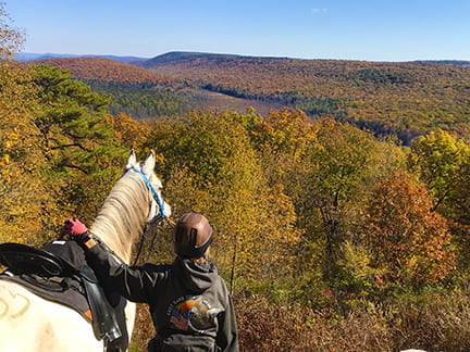
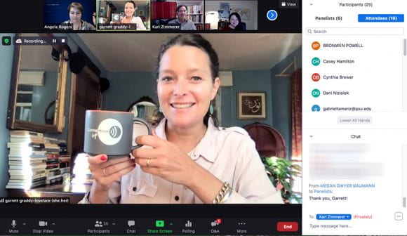
COFFEE HOUR

Coffee Hour with Garrett Graddy-Lovelace
What Accounts for the Mutual Avoidance between Agricultural Policy & Agrobiodiversity Governance? Colonized Geography 

Agricultural policy encompasses a vast, multi-scalar array of laws, regimes, regulations, politics, supports, and governing paradigms related to food, land use, land tenure, water, trade, infrastructure, research, and more. Seeds appear, but largely in relation to phytosanitary and intellectual property rules. (Labor is also missing.) Dominant agricultural policies, epitomized in the United States Farm Bill, avoid addressing much less supporting agricultural biodiversity as such.

NEWS

Fracking bill analysis reveals how states may influence each other’s policies

Even though State governments routinely rely upon interest groups to help them as they craft legislation, researchers found that certain peer-leader states, like Pennsylvania and Colorado, have greater influence in shaping states’ fracking policies, in a study led by Penn State Professor of Geography Jennifer Baka.

The study, titled “Disclosing Influence: Hydraulic fracturing, interest groups, and state policy processes in the United States,” revealed two important findings, Baka said.

Four Penn State researchers join the Social Science Research Institute

Louisa Holmes is among the four

Four Penn State researchers have joined the Consortium to Combat Substance Abuse, part of the Social Science Research Institute, including faculty members from the colleges of Engineering, Earth and Mineral Sciences, and Health and Human Development.

The Consortium to Combat Substance Abuse (CCSA) brings together researchers, educators, and practitioners from Penn State campuses to develop and implement effective programs, policies, and practices aimed at preventing and treating addiction and its spillover effects on children, families, and communities.

Daily Collegian
Penn State women’s soccer alumnae use their platform to advocate for social justice

Geography Alumna Britt Eckerstrom quoted

On June 27, the National Women’s Soccer League’s Portland Thorns FC and North Carolina Courage took the field, marking the first return of a North American professional sports league since the start of the coronavirus pandemic.

RECENTLY PUBLISHED

Historical incidence of mid‐autumn wind storms in New England

Simonson, JM, Birkel, SD, Maasch, KA, Mayewski, PA, Lyon, B, Carleton, AM.
Meteorological Applications
https://doi.org/10.1002/met.1952
New England has seen a number of mid‐autumn (October–November) wind storms—high‐wind events associated with extratropical cyclones—in recent years that have produced extensive infrastructure damage, raising concerns that these events may become more common in a changing climate. Storms developing at this time of year are unique in that they can have dominant cold‐season characteristics while also being fueled by warm‐season moisture sources (such as the remnants of tropical cyclones) or the result of an extratropical transition. To provide insights on the behavior of such storms, we explore recent storm frequency and intensity by using reanalysis and station‐based meteorological observations onward from 1979. Variables taken into consideration include 10 m wind speed, sea‐level pressure and precipitation. The results do not show a statistically significant increase in the overall frequency of mid‐autumn wind storms nor of their intensity with respect to central pressure or surface wind speeds. However, there is a statistically significant trend toward increasing precipitation accompanying wind storms with maximum 10 m wind gusts greater than 26 m⋅s−1 (58 mph). While stronger high‐wind events tend to be associated with lower central sea‐level pressure values and substantial intensification rates, other factors such as storm tracks and the pressure gradient across the New England region also affect the development and overall impact of storms. This study highlights the variety of elements, such as the background climate conditions, which could potentially increase the risk of wind damage in a warming world.

Spatial patterns of nineteenth century fire severity persist after fire exclusion and a twenty-first century wildfire in a mixed conifer forest landscape, Southern Cascades, USA

Taylor, A.H., Airey-Lauvaux, C., Estes, B. et al.
Landscape Ecology
https://doi.org/10.1007/s10980-020-01118-1
Context: Spatial patterns of fire severity are influenced by fire-vegetation patch dynamics and topography. Since the late nineteenth century, fire exclusion has increased fuels and recent fire severity patterns may diverge from historical patterns.

Objectives: We used data from a 2008 wildfire burning in a landscape with known nineteenth century fire severity patterns to answer the following questions: (1) Were the spatial patterns of fire severity and fire effects after the 2008 fire similar to those in the late nineteenth century? (2) What factors were most important in controlling spatial patterns of fire severity in 2008?

Methods: Fire severity patterns in the late nineteenth century were identified by Beaty and Taylor (J Veg Sci 18:879, 2001) using dendroecology. Plots were remeasured after the 2008 fire and geospatial layers of vegetation type, topography, fire weather, daily fire extent and fire severity were used to identify controls on 2008 fire severity.

Results: Fire severity in 2008 varied in ways similar to the nineteenth century. Tree mortality and bark char in plots were lowest on lower slopes and southwest facing slopes, intermediate on middle slopes, and highest on upper slopes and northeast slopes. At the landscape scale, vegetation type, elevation, slope aspect, slope position and weather were the variables controlling fire severity.

Conclusions: Spatial patterns of fire severity persisted, despite more than a century of fire exclusion. Our findings suggest that wildfires burning under moderate conditions even with a warming climate can help reduce the fire deficit and promote forest resilience in fire prone landscapes.

Design of a Serious Game to Inform the Public About the Critical Zone

Pejman Sajjadi, Mahda M. Bagher,  Zheng Cui,  Jessica G. Myrick,  Janet K. Swim, Timothy S. White, Alexander Klippel
2020 IEEE 8th International Conference on Serious Games and Applications for Health (SeGAH)
doi: 10.1109/SeGAH49190.2020.9201697
https://www.researchgate.net/publication/344405091_Design_of_a_Serious_Game_to_Inform_the_Public_About_the_Critical_Zone
The Critical Zone (CZ), the near surface more portion of the terrestrial Earth is a complex concept that plays a pivotal role in the food-energy-water nexus. Due to its complexity, the concept of the CZ and its components are not well understood by society. Challenges range from imagining the invisible (the soil, rock, and water beneath us) to understanding complex relations between the involved components. To create awareness on a societal level, we have initiated a transdisciplinary project driven by immersive and gaming technologies that allow for an extension of what physical reality offers society about the concept of the CZ. We have developed a serious iVR game that enables learners to have a concrete experience about the CZ, and how natural and human processes affect it.


Skip to toolbar