26
Jan 16

Coffee Hour with Qunying Huang | Social media aids disaster response | AAG prelim program

IMAGE OF THE WEEK

NASAJan25imageday

NASA Space Station Flyover of the Mediterranean: Expedition 46 flight engineer Tim Peake of the European Space Agency (ESA) shared this stunning nighttime photograph on Jan. 25, 2016, writing, “Beautiful night pass over Italy, Alps and Mediterranean.”

GOOD NEWS

NEWS

Coffee Hour with Qunying Huang
Social media: an emerging data source for human mobility studies
While most previous studies relied heavily on the expensive travel-diary type data, social media now emerges as a new data source to describe human daily activity patterns and population dynamics. Despite the various appealing aspects of social media data, including a much larger numbers of “subjects,” low acquisition cost and relatively wide geographical and international coverage, these data also have many limitations, including sparseness and irregularity of sampling points over space and time, and the lack of background information of users, such as home locations and socioeconomic status (SES).

  • 3:30 to 5:00 p.m.
  • Refreshments are offered in 319 Walker Building at 3:30 p.m.
  • The lecture begins in 112 Walker Building at 4:00 p.m.
  • Coffee Hour To Go Webcast
  • Next week: Hamil Pearsall “Growing a sustainable city? The question of urban agriculture”

Mining social media can help improve disaster response efforts
Leveraging publicly available social media posts could help disaster response agencies quickly identify impacted areas in need of assistance, according to a Penn State-led team of researchers. By analyzing the September 2013 Colorado floods, researchers showed that a combination of remote sensing, Twitter and Flickr data could be used to identify flooded areas.

Preliminary edition of the AAG 2015 conference program is available online
The online, searchable program includes a preliminary agenda of sessions, plenary speakers, and specialty group meetings. You can browse the program by presenter, keyword, title, or specialty group. You can also view sessions by day using the calendar of events.

RECENTLY (OR SOON TO BE) PUBLISHED

“High severity fire and mixed conifer forest-chaparral dynamics in the southern Cascade Range, USA”
By Catherine Airey Lauvaux, Carl N. Skinner, Alan H. Taylor in Forest Ecology and Management
DOI:10.1016/j.foreco.2015.12.016
Understanding how alternative vegetation types co-exist in a landscape is important in managing for biodiversity within an ecosystem. In California, mixed conifer forest is often interrupted by stands of shrubs known as montane chaparral. The development of chaparral stands following recent high severity or stand-replacing wildfires in mixed conifer forests has been well documented. Fire has been excluded from mixed conifer forests for over a century, and fuel loads are at historically high levels across much of this landscape.

“Species and site difference influence climate-shrub growth response in West Greenland”
By Amanda Young, David Watts, Alan Taylor, and Eric Post in Dendrochronologia
DOI:10.1016/j.dendro.2015.12.007
We examined the suitability of two deciduous arctic shrubs (Salix glauca L. and Betula nana L., hereafter Salix and Betula, respectively) for dendroclimatological analysis at two sites in West Greenland. Chronologies were successfully cross-dated, and the oldest covered the period 1954–2010 (Expressed Population Signal [EPS] > 0.85, 1977–2010). Distinctive pointer years, also called micro-rings, including those from a known outbreak of the irruptive moth Eurois occulta L. (Lepidoptera: Noctuidae) that peaked in 2005, assisted in the dating process.

“Situated knowledge of pathogenic landscapes in Ghana: Understanding the emergence of Buruli ulcer through qualitative analysis”
By Petra Tschakert, Vincent Ricciardi, Erica Smithwick, Mario Machado, David Ferring, Heidi Hausermann, Leah Bug in Social Science & Medicine
DOI:10.1016/j.socscimed.2015.12.005
At a time when fear and misinformation about uncommon diseases have become a fixture of our global dialogue, the opportunity is ripe to re-evaluate our understanding of health crises as they relate to society as a whole. Buruli ulcer (BU), an aggressive infection that degrades the skin, soft tissue, and bone of affected individuals, represents one such poorly-understood and stigmatized disease.

DOG OF THE WEEK

IMG_2155.JPGHope we did not catch you catnapping. “Dog” may be our catchword, but this week’s animal companion is no canine. Will this catalyze you to send in a photo of your animal companion? Who is this feline? Who are her humans?


18
Jan 16

Coffee Hour with Alton Byers | Rapid FQI | MOOC maps

IMAGE OF THE WEEK

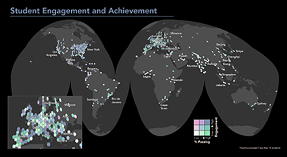
Mapping the location of the 49,000 students who take a MOOC called “Maps and the Geospatial Revolution,” revealed some interesting patterns. See related story below.

GOOD NEWS

The Population Association of America (PAA) has just announced that Stephen A. Matthews and two Penn State colleagues will be the next co-editors of its flagship journal, Demography.

Russ Hedberg received funding from the National Science Foundation for a doctoral dissertation research improvement grant.

Sterling Quinn accepted a job as assistant professor of Geography at Central Washington University, beginning September 2016.

Cynthia A. Brewer’s new edition of Designing Better Maps: A Guide for GIS Users, has been published by Esri.

Professor Emeritus Lucky Yapa’s son Sunil was interviewed on Late Night with Seth Myers about his novel, “Your Heart is a Muscle the Size of a Fist.”

Alumnus Vaclav Smil (Ph.D. ’69) was mentioned in Bill Gates book blog: https://www.gatesnotes.com/Books/Should-We-Eat-Meat

NEWS

Coffee Hour with Alton C. Byers
Impacts of the April 27, 2015 Nepal earthquake on four potentially dangerous glacial lakes in Nepal
On April 25, 2015, a magnitude 7.8 earthquake struck central Nepal, causing more than 8,000 deaths throughout the country. Two weeks later, a magnitude 7.3 aftershock caused further damage and uncertainty. Massive landslides wiped out entire villages, rivers were dammed by landslides, and the geologic and geomorphic integrity of high altitude mountains and glaciers was destabilized. Scientists throughout the world began to worry that the seismic activity could also result in new glacial lake outburst floods (GLOFs) through the weakening of terminal moraines and destabilization of potential triggers, such as overhanging ice and landslides.

  • 3:30 to 5:00 p.m.
  • Refreshments are offered in 319 Walker Building at 3:30 p.m.
  • The lecture begins in 112 Walker Building at 4:00 p.m.
  • Coffee Hour To Go Webcast
  • Next week: Qunying Huang “Social media: an emerging data source for human mobility studies”

Department of Geography announces spring 2016 Coffee Hour speakers
Coffee Hour has been presented weekly by the Department of Geography for 48 years to promote collegiality and discussion around entertaining and thought-provoking topics. Topics have included climate change, online learning, social justice, mass transit, carbon sequestration and cartography.

Rapid version of assessment tool provides easier way to monitor
wetland quality
A modified or “rapid” version of an existing wetland assessment tool can accurately assess the quality of wetlands, according to Penn State researchers. Using the rapid version of the tool, known as the Floristic Quality Assessment Index (FQI), can save time and improve upon wetland monitoring strategies.

“Some U.S. states have lost 90 percent of their wetlands since the 1950s, and, of the ones that are left, many are being degraded,” said Sarah Chamberlain, senior research assistant and botanist for Penn State’s wetland research center, Riparia, and lead author on the findings published in the current issue of Ecological Indicators.

Mapping internships teach geography student importance of field work
Ryan Gallagher has certainly mapped his way to a foundation for entering the field in geography. Over the last two summers, Gallagher, a Schreyer Scholar majoring in geography at Penn State, completed two internships that did something positive — first, mapping stormwater drainage systems for College Township, in State College, Pennsylvania; then mapping data for Riparia, a wetlands research center housed in Penn State’s Department of Geography on the University Park campus.

RECENTLY (OR SOON TO BE) PUBLISHED

Mapping a MOOC Reveals Global Patterns in Student Engagement
By Anthony C. Robinson in The Chronicle of Higher Education
Teaching an online course that 49,000 students have signed up for presents an unprecedented challenge when it comes to an important aspect of instruction: knowing your audience. I could see from my course “dashboard” in Coursera that the students hailed from 190 countries, with 6 percent from India, 31 percent from the United States, and so on, but these numbers only took me so far. I wondered which places had lots of students earning a passing grade? Which places had students who were really engaged with the course? Since I’m a cartographer, it made sense to make some maps.

Towards contextualized models of spatial relations
By Jan Oliver Wallgrün, Alexander Klippel, Morteza Karimzadeh in Proceedings of the 9th Workshop on Geographic Information Retrieval
DOI: 10.1145/2837689.2837692
We argue that Geographic Information Retrieval has a lot to gain from the creation of contextualized models of spatial relations that capture how human usage of spatial relational expressions is affected by contextual factors. We propose a framework to develop such models and discuss challenges.

Fine-grain spatial patterning and dynamics of land use and agrobiodiversity amid global changes in the Bolivian Andes
By Karl S. Zimmerer and Hector Luis Rojas Vaca in Regional Environmental Change
DOI: 10.1007/s10113-015-0897-8
Our research addresses the gap in scientific research on the fine-grain spatial patterns and social–ecological interactions of land use and agrobiodiversity. The spatial dimension of agrobiodiversity dynamics potentially strengthens the social–ecological resilience and food security of smallholders by buffering risk and vulnerability.

DOG OF THE WEEK

We received a few incorrect guesses, but last week’s dog was Galway, a beagle mix and companion to Lorraine Dowler. Keep the dog pictures coming!


14
Jan 16

Coffee Hour with Rob Brooks

Editor’s note: an off-field injury has taken scheduled speaker Jia-Ching Chen out of the game this week. Rob Brooks will substitute in.

Coffee Hour with Rob Brooks “The Art and Science of Translating Ecological Indicators to Ecosystem Services in Riparia “
As we seek to identify and value the benefits accrued to people from ecosystem services, one task we face is how to relate measures of ecological condition – or ecological indicators – to those services on which we place value. Multiple approaches from the literature are profiled briefly, followed by a case study with a focus on demonstrating how anthropogenic impacts in agrarian landscapes affect field-based indicators of stream, wetland, and riparian condition. How can incremental changes in condition metrics be used to predict changes in levels of services that are provided by healthy aquatic ecosystems, for water purification, floodwater storage, carbon sequestration, aquatic biodiversity, and water-based recreation?

  • 3:30 to 5:00 p.m.
  • Refreshments are offered in 319 Walker Building at 3:30 p.m.
  • The lecture begins in 112 Walker Building at 4:00 p.m.
  • Coffee Hour To Go Webcast
  • Next week: Alton Byers “Impacts of the 27 April, 2015 Nepal earthquake on four potentially dangerous glacial lakes in Nepal”

11
Jan 16

Coffee Hour with Jia-Ching Chen | New maps | Spring UROC projects | Dog of the week is back

IMAGE OF THE WEEK

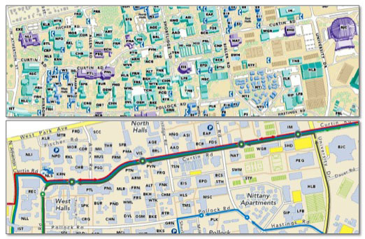
comparison of campus mapsA comparison of two different map formats for University Park campus. On the top, the old style shows 3-D buildings. On the bottom, the new style shows simpler building footprints and bus routes. See related story below.

GOOD NEWS

SWIG exceeded its goal and collected enough money to sponsor a mom, her two young children and purchase 5 additional gift cards for women and children at the Centre County Women’s Resource Center. Thanks to everyone in the department who contributed so generously.

Aparna Parikh has been elected as a new grad rep. She joins Ashlee Adams, Adrienne Tucker, and Carolyn Fish as your graduate representatives.  Her term will run through December 2016.

Azita Ranjbar’s opinion piece on H.R. 158 “When Rhetoric Becomes Reality: Changes to Visa Waiver Program Create Second-Class Citizens” was published on Huffington Post.

Ashlee Adams’s book review of “Seeds of resistance, seeds of hope: place and agency in the conservation of biodiversity” has been published in the journal Agriculture and Human Values.

NEWS

Coffee Hour with Jia-Ching Chen: “Forging Low-Carbon Value: People, Places and Things in the Global Green Economy”
How do markets for renewable energy commodities like solar panels capture and represent low-carbon value? This talk examines the geography of low-carbon value in the transformation of Yixing, a municipality in China’s Jiangsu province, and the site of large scale state investment and master planning in the renewables industries beginning in 2006. Using a political industrial ecology approach, I examine the changing social-environmental relationships surrounding the construction of a solar photovoltaics industrial cluster that now accounts for approximately ten percent of global manufacturing capacity.

  • 3:30 to 5:00 p.m.
  • Refreshments are offered in 319 Walker Building at 3:30 p.m.
  • The lecture begins in 112 Walker Building at 4:00 p.m.
  • Coffee Hour To Go Webcast
  • Next week: Alton Byers “Impacts of the 27 April, 2015 Nepal earthquake on four potentially dangerous glacial lakes in Nepal”

Gould Center releases updated University Park campus maps
Situated on more than 8,500 acres with nearly 300 academic, administrative and residential buildings, Penn State’s University Park campus is a big place. As a service to the University community and the thousands of annual visitors, the Peter R. Gould Center for Geography Education and Outreach in Penn State’s Department of Geography has produced maps of the University Park campus for more than 20 years. The newly updated 2016 maps are now available for downloading and printing.

Undergraduate Research Opportunities Connection (UROC) now ready for applications
Undergraduate students looking for a way to gain research experience as well as 1 to 3 credits, can now apply for spring 2016 undergraduate research projects supervised by graduate students in the Department of Geography. To view the new projects and apply, go to: http://www.geog.psu.edu/uroc

RECENTLY (OR SOON TO BE) PUBLISHED

“The Sociospatial Network: Risk and the role of place in the transmission of infectious diseases.”
By Jay Logan (MGIS 2014), A.M. Jolly, and Justine Blanford In PlosOne

“Using small cities to understand the crowd behind OpenStreetMap”
By Sterling Quinn in GeoJournal
DOI: 10.1007/s10708-015-9695-6

Using Twitter for tasking remote-sensing data collection and damage assessment: 2013 Boulder flood case study
By Guido Cervone , Elena Sava , Qunying Huang , Emily Schnebele , Jeff Harrison , Nigel Waters in International Journal of Remote Sensing
DOI: 10.1080/01431161.2015.1117684

“Intuitive Direction Concepts”
By Alexander Klippel, Jan Oliver Wallgrün, Jinlong Yang, Kevin Sparks in The Baltic International Yearbook of Cognition, Logic and Communication
DOI: http://dx.doi.org/10.4148/1944-3676.1103

“Species and site differences influence climate-shrub growth responses in West Greenland”
By Amanda B. Young, David A. Watts, Alan H. Taylor, Eric Post in Dendrochronologia
doi:10.1016/j.dendro.2015.12.007

DOG OF THE WEEK

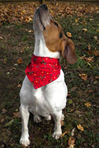
Jan12dogWho is this dog? Who is his human? Send your answer and/or send a photo of your animal companion to geography@psu.edu.


Skip to toolbar