30
Sep 19

Coffee Hour with Laura Leites | We’re hiring faculty | Undergraduate certificates

IMAGE OF THE WEEKAdviser and student

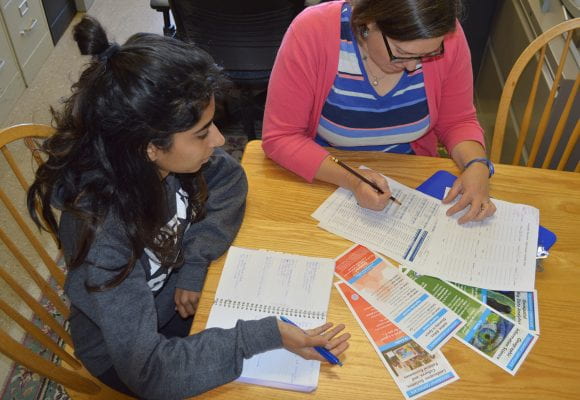
Adviser Jodi Vender helps undergraduate student Harman Singh plan which courses to take to fulfill the requirements for a certificate in geography. Image: Penn State.

GOOD NEWS

Jamie Peeler was awarded a Graduate Research Innovation Award from the Joint Fire Science Program for her dissertation research in Wyoming.

The EMS Graduate Student Poster Competition and Recognition will take place on Wednesday, October 23. Emily Domanico, Ruchi Patel, and Jaiyan Zhao have been selected to represent our department in the poster competition.

Justine Blanford has a position paper accepted to the Spatial Data Science Symposium: Setting the Spatial Data Science Agenda, December 9–11, 2019

MGIS Student Brandon Green has had a paper “Estimating populations in refugee camps: a toolkit using remotely sensed data” accepted by Digital Government: Disaster Information, Technology, and Resilience Track.

Mikael Hiestand and Andrew Carleton have had a paper, “Growing Season Synoptic and Phenological Controls on Heat Fluxes over Forest and Cropland Sites in the Midwest U.S. Corn Belt,” accepted by the Journal of Applied Meteorology and Climatology.

COFFEE HOUR

Coffee Hour with Laura Leites
Adaptation to climate in forest tree species and implications under a changing climate

More than a century of field studies has demonstrated that forest tree species with large geographic ranges are commonly composed of populations genetically adapted to the climate they inhabit. These populations occupy only a segment of the species climatic range, but their existence allows the species to accommodate the large spatial climate variability within their vast geographic ranges. Adaptation to climate is primarily achieved by synchronizing the trees’ annual growth cycle with the frost-free period of the inhabited climate in order to avoid unfavorable conditions through dormancy. As climate warms, genotypes and climate will be misaligned with important consequences for the growth and survival of forest tree species. However, there are opportunities for management to aid in maintaining well-adapted and productive forests. In this talk I’ll synthesize our knowledge of adaptation to climate in forest tree species, discuss implications under a warming climate, and review management practices aimed at re-aligning genotypes and climate.

  • Friday, October 4, 2019
  • Refreshments are offered in 319 Walker Building at 3:30 p.m.
  • Lecture begins in 112 Walker Building at 4:00 p.m.
  • Coffee Hour to Go on Zoom

For more information about Coffee Hour and to view previously recorded Coffee Hour talks visit https://www.geog.psu.edu/calendar/coffee-hour-lecture-series

NEWS

JOB POSTING

Assistant Professor of Health Geography

The Department of Geography at The Pennsylvania State University in State College, Pennsylvania invites applications for a tenure-track Assistant Professor faculty position in Health Geography with a focus on Substance Use and Misuse. Preference will be given to candidates with a research focus in the United States and who utilize quantitative and spatial techniques to address subjects including but not limited to social determinants, population patterns, and health care delivery pertaining to substance use and misuse.

JOB POSTING

Faculty Positions in Understanding Land-Water Systems using Data Analytics

The College of Earth and Mineral Sciences through the Earth and Environmental Systems Institute (EESI) at The Pennsylvania State University, University Park, PA, seeks to hire tenure-line faculty at the assistant or associate rank who study Earth and environmental sciences using new data-driven tools and methods. Candidates for the rank of associate professor typically will have several years of research experience and already hold tenure at another institution and/or qualify for immediate tenure at Penn State.

Geography certificates offer customized degrees for undergraduates

Penn State students who want to customize their bachelor’s degree in geography, add a specific topic in geography to their major, or enhance their career as a non-degree student can now complete undergraduate certificates in geography.

“Certificates are credentials that recognize mastery of a specific area in the discipline,” said Jodi Vender, undergraduate adviser in the Department of Geography. “Ours are 12 credits — fewer credits than a minor — so they fit more easily into a degree program. They can be used as milestones for accomplishment in a specific domain or can stand alone.”

Model helps choose wind farm locations, predicts output

The wind is always blowing somewhere, but deciding where to locate a wind farm is a bit more complicated than holding up a wet finger. Now a team of Penn State researchers have a model that can locate the best place for the wind farm and even help with 24-hour predictions of energy output.


24
Sep 19

Coffee Hour: a critical conversation in geography | New geog faculty | Alum in Annals of the AAG

IMAGE OF THE WEEK

Pictured at the Lion Shrine, left to right, the new geography faculty members: Luke Trusel, Trevor Birkenholtz, Emily Rosenman, Helen Greatrex, Manzhu Yu, and Panagiotis Giannakis. See news story below; full profiles of all six are forthcoming in the printed Geograph annual newsletter.
GOOD NEWS

Gamma Theta Upsilon & GIS Coalition will hold an internship round table and resume review to talk about how to find an internship as a geographer on Tuesday, Sept. 24 at 6:00 p.m. in 110 Walker Building to hear other students talk about internships, from the application process to the internship experience itself.

The College of Earth and Mineral Sciences’ 2019 International Culture Night will be held 6 to 7:30 p.m. Tuesday, Sept. 24, in the Atrium of the Steidle Building on the University Park campus. The event is free and open to the public.

A free screening of the documentary film “Elephant Path / Njaia Njoku” will take place at 6:30 p.m. Wednesday, Sept. 25, in the HUB-Robeson Center’s Freeman Auditorium on Penn State’s University Park campus. A Q&A with the director will follow.

Sara E. Cavallo will give a brownbag talk on “Navigating Compounding Uncertainty: Farmer Strategies amid Biosecurity Crises in Western Uganda,” Wednesday, October 2, from 12:30–2:00 p.m. in 133 Sparks Building.

The EMS Graduate Student Poster Competition and Recognition will take place on Wednesday, October 23, in 401/402 Steidle Building. Poster Session and Catered Reception from 3:00 to 4:30 p.m. Awards Presentation and Special Recognition of Graduate Excellence from 4:30 to 5:00. RSVP by Friday, October 4, 2019.

The inaugural Geospatial Technology and Spatial Data Science Symposium will be held on November 11, 2019, as part of Geography Awareness Week and GIS Day at Penn State.

Call for Papers: The African Studies Program, 7th annual conference, on April 17-18, 2020, “Africa on the Rise! 60 years after 1960,” commemorates the “Year of Africa.” Abstracts of 200 words (max) are due by Dec. 5, 2019. Submit your abstract.

COFFEE HOUR

Coffee Hour: Critical Conversation in Geography

On September 20 and 27, 2019, the Fridays for Future movement has called for a global climate strike to demand an end to fossil fuels. We are responding to these calls from youth across the globe by convening an open conversation about the role of geography—and geographers—in responding to the climate crisis for the September 27 Coffee Hour.

Questions that may frame the conversation include: What kind of climate research is necessary and important? What are new opportunities? What is the role of advocacy, engagement, and outreach? Can the department follow other geography departments in calculating our departmental carbon footprint— and are there ways to reduce it?

  • Friday, September 27, 2019
  • Refreshments are offered in 319 Walker Building at 3:30 p.m.
  • Lecture begins in 112 Walker Building at 4:00 p.m.
  • Coffee Hour to Go on Zoom

More information about Coffee Hour and to view previously recorded Coffee Hour talks

NEWS

The new geographers: Six faculty hires are driving the future of the field

Six new tenure-line geography faculty started this fall in the Department of Geography, College of Earth and Mineral Sciences. They will conduct research on a wide variety of subjects including water, climate change, natural hazards, remote sensing, social networks, data mining, economics, and inequality and diversity.

“The new geographers are bringing in not only their scientific expertise but also experience in using multiple research methods, and a dedication to engaging livelihoods and environments,” said Cynthia Brewer, professor and head of the department. “Their expertise will also be used to create new courses for our students.”

Individual profile articles for all six new geographers are forthcoming in the printed Geograph annual newsletter.

RECENTLY PUBLISHED

Making an Anthropocene Ocean: Synoptic Geographies of the International Geophysical Year (1957–1958)

Jessica Lehman ’08
Annals of the American Association of Geographers
DOI: 10.1080/24694452.2019.1644988
Although the notion of the Anthropocene has generated a great deal of literature across disciplines, the geographic critique of this concept is still developing. This article contributes to justice-oriented engagements with the Anthropocene by highlighting the relationships through which planetary knowledge is constructed as sites of critique. I develop an analytic of synoptic geographies, which addresses the praxis of coordinated field measurements that creates the planetary knowledge on which concepts of the Anthropocene rest. Synoptic geographies require a geographic analytic that is capable of going beyond assertions that all knowledge is local. The International Geophysical Year (IGY; 1957–1958) provides a strategic opportunity to elaborate the stakes of synoptic geographies. The IGY was arguably the first attempt to understand the Earth as a planet through a program of widespread synoptic data collection. In particular, the synoptic geographies of the IGY’s oceanography program reveal the ways in which old and new forms of imperialism were knitted together to produce the world ocean as an object of knowledge in a new era of planetary-scale environmental politics.


17
Sep 19

Coffee Hour with Claudia Ringler | Drawdown Scholars | Hamer mapping sessions

IMAGE OF THE WEEK

Coffee Hour speakers Marla Lugo-Perez (left) and Cecilio Ortiz Garcia (right) with Speakers Committee Chair Erica Smithwick (center), after the September 13 talk, “Understanding Hurricane Maria: Disaster Response as Transition Management,” which is available to view now on the new Coffee Hour Channel.

GOOD NEWS

The inaugural Geospatial Technology and Spatial Data Science Symposium will be held on November 11, 2019, as part of Geography Awareness Week and GIS Day at Penn State. https://sites.google.com/view/geospatialsymposium2/home.

Esri recruiters are visiting campus this week. They will be at the Career Fair on Wednesday and Thursday, hold an info session in Walker Building on Thursday evening, and conduct interviews (pre-selected) in Walker Building on Friday for internship and full-time positions. For more information, visit https://www.esri.com/en-us/about/careers/student-jobs

Jack Dangermond, founder and president of Esri, will visit Penn State on Oct. 2 as part of the Department of Landscape Architecture’s Bracken Lecture Series. His talk — titled “Geography and Landscape: The Foundations for Geodesign” — will be held at 6 p.m. in the HUB’s Freeman Auditorium.

COFFEE HOUR

Coffee Hour with Claudia Ringler
Achieving nutrition outcomes through improved agricultural water management: What are the options?

One out of three people in the world suffers from one or several forms of malnutrition—and every third person lives in a water-stressed environment—and both trends are worsening. It is, however, not only the magnitudes that link water and nutrition—the challenges and solutions are also closely interlinked—so interlinked, in fact, that achieving the SDG targets for water without consideration of other goals and targets could well constrain efforts to reach SDG targets on nutrition—and vice versa. This talk describes ongoing work by the International Food Policy Research Institute and partners on the linkages between water and nutrition, and provides case study and empirical results for Sub-Saharan Africa.

  • Friday, September 20, 2019
  • Refreshments are offered in 319 Walker Building at 3:30 p.m.
  • Lecture begins in 112 Walker Building at 4:00 p.m.
  • Coffee Hour to Go on Zoom

NEWS

Drawdown Scholars returning to Penn State for international conference

Whitney Ashead, geography and agricultural science double major, Nebraska Hernandez, geography and Spanish double major, are participants

Undergraduate students from across the country are returning to Penn State next week for the first international conference on the science of drawdown, the point at which greenhouse gases in the atmosphere begin to decline. The students, participants in this past summer’s Penn State Drawdown Scholars Research Experience for Undergraduates Program, will present results from their summer research projects from Sept. 16-18.

New graduate, undergraduate student groups strive to increase museum involvement

Michelle Ritchie, Department of Geography rep., to create an exhibit on women in geography

Two new College of Earth and Mineral Science’s (EMS) student groups were recently formed to strengthen the Earth and Mineral Sciences Museum & Art Gallery’s connection to the college, the University and local communities. The graduate group, the Society for Museum Science Education (SoMuSE), and the undergraduate Museum Club envision the museum as the hub of EMS: a space to connect the community within and beyond the college and to experience the college’s diversity of research and historic collections. The clubs plan to organize events and exhibits that educate, inspire and celebrate the EMS community.

University Libraries announces fall Maps and Geospatial Informational Sessions

This fall, the Donald W. Hamer Center for Maps and Geospatial Information at the Penn State University Libraries will offer three informational sessions relating to foundational map and geospatial topics. Designed to provide an introduction to maps and geospatial resources and expertise available at the Libraries, these sessions aim to engage participants across disciplines in their use of geospatial information.

Sessions are open to all Penn State students, staff, faculty and the public. Advance registration is not required. All sessions will be held in 211A Pattee Library on the University Park campus, with remote viewing available online via Zoom.


09
Sep 19

Coffee Hour with Marla Lugo Perez and Cecilio Ortiz Garcia | Helping Arctic communities | Climate conference

IMAGE OF THE WEEK

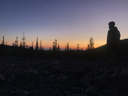
Sunset in Lassen Volcanic National Park

August sunset near Penn State geography field team (Lucas Harris, Sam Black, Alex Nawn, Alan Taylor) campsite in Lassen Volcanic National Park, California. Photo: Alan Taylor.

GOOD NEWS

Plan to attend the Geography Fall Welcome Picnic on September 14. For more information and to RSVP go to: https://www.geog.psu.edu/event/geography-fall-welcome-picnic-2019

Jennifer Baka was appointed to the Environmental Justice Advisory Board for the Pennsylvania Department of Environmental Protection (DEP) starting in January 2020.

COFFEE HOUR

Coffee Hour with Marla Lugo Perez and Cecilio Ortiz Garcia

Understanding Hurricane Maria: Disaster Response as Transition Management

The generalized claims about the inadequacies of the governmental response to Hurricane Maria in Puerto Rico, at both the local and federal levels, highlight a simple but often overlooked fact: disasters do not occur in a vacuum, neither societies that experience them are “blank canvases” or “clean slates” from which the reconstruction starts from scratch. From macro level abstractions such as the governance limbo brought by PROMESA, to the very concrete experience of uncommunicated communities that were required by the FederalEmergency Management Agency (FEMA) to file claims online, disaster response and recovery in Puerto Rico reveals the multilevel complexities of disasters that transcend the organizational misalignments often documented in the disaster literature. We suggests that disaster response still suffers, to this day, from a myopic view of disasters. Disasters are still being treated as discrete events to which societal institutions must respond to and recover from by reinstating equilibrium, often understood as pre-event conditions. We propose that disaster response and recovery should be understood as transition management tools to reach a new resilient and more sustainable state. Models such as the multilevel perspective (MLP) and the sustainable transitions often used to examine socio-technical and socio-ecological transformations, can help us better understand the alignment or misalignment of preparedness, response,recovery and mitigation related policies and activities. These models can also help us visualize much needed policy interventions that mitigate vulnerabilities and decrease disaster. In fact, this paradigmatic change invites us to redefine the very concepts of vulnerability and resilience understanding the value judgments that these often carry.

  • Friday, September 13, 2019
  • Refreshments are offered in 319 Walker Building at 3:30 p.m.
  • Lecture begins in 112 Walker Building at 4:00 p.m.

NEWS

Helping Alaskan coastal communities adjust to global warming

Bronwen Powell is on the team

Alaskan coastal Indigenous communities are facing severe environmental changes that threaten to irrevocably damage their way of life. A $3 million grant from the National Science Foundation (NSF) will allow Penn State researchers to assist local communities with foreseeable environmental challenges and work towards building more resilient communities.

The project, “Pursuing Opportunities for Long-term Arctic Resilience for Infrastructure and Society,” or POLARIS, is funded through NSF’s new “Navigating the New Arctic” program, which will establish a network of platforms and tools across the Arctic to document and understand the Arctic’s rapid biological, physical, chemical and social changes.

Climate conference to feature Penn State researchers Sept. 16-18

Erica Smithwick is participating

More than 20 Penn State researchers are participating in the upcoming climate solutions conference Research to Action: The Science of Drawdown. Overall, more than 70 speakers will be presenting at the event, which will take place Sept. 16-18 at the Penn Stater Hotel and Conference Center.

RECENTLY PUBLISHED

Visualizing Natural Environments from Data in Virtual Reality: Combining Realism and Uncertainty

J. Huang, M. S. Lucash, M. B. Simpson, C. Helgeson and A. Klippel
2019 IEEE Conference on Virtual Reality and 3D User Interfaces (VR), Osaka, Japan, 2019
doi: 10.1109/VR.2019.8797996
Understanding complex scientific data visualizations in 2D can be challenging. Virtual Reality (VR) provides an alternative, combining realistic 3D representations with intuitive, natural interactions with data through embodied experiences. However, realistic 3D representations and associated immersive experiences are prone to misrepresentations as they are selectively representative and often leave little room for abstraction. This is particularly challenging for topics such as modeling natural environments where users value realism. We discuss the causes and categories of potential misrepresentations in VR with a particular focus on scientific visualization. We contextualize our discussion by presenting an application prototype that translates ecological model output data into a high-fidelity VR experience that allows users to walk through forests of the future. We also designed and implemented two methods to display uncertainties in high-fidelity VR environments: A multi-scenarios approach to provide users access to alternative scenarios, and a slide-and-show approach to view the environment within the confidence interval.

Visualizing Ecological Data in Virtual Reality

J. Huang, M. S. Lucash, R. M. Scheller and A. Klippel
2019 IEEE Conference on Virtual Reality and 3D User Interfaces (VR), Osaka, Japan, 2019
doi: 10.1109/VR.2019.8797771
Visualizing complex scientific data and models in 2D can be challenging. The result can be hard to interpret and understand for the general audience, and the model accuracy hard to evaluate even for the experts. To address these problems, we created a workflow that translates data of an ecological model, LANDIS-II, into a high-fidelity 3D model in virtual reality (VR). We combined ecological modeling, analytical modeling, procedural modeling, and VR, to allow users to experience a forest in northern Wisconsin (WI), United States, under two climate scenarios. Users can explore and interact with the forest under different climate scenarios, explore the impacts of climate change on different tree species, and retrieve information from a 3D tree database. The VR application can be used as an educational tool for the general public, and as a model checking tool by researchers.

Warping Space and Time-Reviving Educational Tools of the 19th Century

A. Klippel, J. O. Wallgrün, A. Masrur, J. Zhao and P. LaFemina
2019 IEEE Conference on Virtual Reality and 3D User Interfaces (VR), Osaka, Japan, 2019
doi: 10.1109/VR.2019.8797897
xR has the potential to warp both space and time. We demonstrate this potential by designing a mixed reality application for mobile devices for the Penn State’s Obelisk, a historic landmark on the main Penn State campus that artistically reveals the geological history of Pennsylvania. Our AR application allows for placing a model of the Obelisk on any surface, interacting with the individual stones to reveal their geological characteristics and location of excavation, and changing to an immersive VR experience of this location based on 360° imagery. Originally conceptualized as a teaching tool for the School of Mines, our xR application revives the Obelisk’s long forgotten mission and allows educators to integrate it once more into the curriculum as well as creatively expand its potential.

Research Framework for Immersive Virtual Field Trips

A. Klippel, J. Zhao, D. Oprean, J. O. Wallgrün and J. S. Chang
2019 IEEE Conference on Virtual Reality and 3D User Interfaces (VR), Osaka, Japan, 2019
doi: 10.1109/VR.2019.8798153
Virtual field trips have been thought of and implemented for several decades. For the most part, these field trips were delivered through desktop computers and often as interactive but strictly two-dimensional experiences. The advent of immersive technologies for both creating content and experiencing places in three dimensions provides ample opportunities to move beyond the restrictions of two dimensional media. We propose here a framework we developed to assess immersive learning experiences, specifically immersive virtual field trips (iVFTs). We detail the foundations and provide insights into associated empirical evaluations.


03
Sep 19

Coffee Hour with Jenn Baka | Meckler receives Murphy Award | AI focuses on dynamic weather

IMAGE OF THE WEEK

Commencement at Bank of Springfield Center Saturday, May 11, 2019.

In May 2019 Hilary Anne Frost ’01g retired as a faculty member from the University of Illinois Springfield. She was named Grand Marshall for this spring’s commencement ceremonies and is now associate professor emerita. Her doctoral dissertation was turned into the monograph Cultural Districts: The Arts as a Strategy for Revitalizing Our Cities, for the Institute for Community Development and the Arts (Washington, DC) and she lectured extensively across the United States about cultural districts. At the University of Illinois Springfield, Frost served as the Director of the Community Arts Management Program and as an assistant professor in the Department of Public Administration from 1997 to 2005. Since 2007 she served as associate professor and director of the Global Studies program where she developed this inaugural program and created and taught innovative introductory and capstone courses.

GOOD NEWS

Mark your calendar for the Geography Fall Welcome Picnic on September 14. For more information and to RSVP go to: https://www.geog.psu.edu/event/geography-fall-welcome-picnic-2019

WE ARE for Science and the Society for Museum Science Education (SoMuSE) are hosting a Diversity Mixer in the Earth and Mineral Science Museum (ground floor, Deike Building) on Wednesday, September 18 from 5:00 to 7:00 p.m. Food will be provided, and ALL are welcome!

Emily Rosenman is featured in the City Road podcast on “Social Impact Investment and Cities”

Recent PhD graduates Morteza Karimzadeh ’18g and Azita Ranjbar ’17g have started new tenure track assistant professor positions in Geography at the University of Colorado, Boulder.

Former GeoVISTA postdoc Liping Yang has accepted a tenure-track position (starting in January 2020) as an assistant professor in the Department of Geography & Environmental Studies at the University of New Mexico.

COFFEE HOUR

Coffee Hour with Jenn Baka: Cracking Appalachia: A Political-Industrial Ecology Perspective

A massive industrial re-development project is underway in the wet gas regions of the Marcellus and Utica shale basins of Pennsylvania, Ohio, and West Virginia. State governments have been coordinating and competing to establish a global petrochemicals industry using ethane by-products from hydraulically fractured shale gas. There are reportedly enough ethane reserves in the basins to support up to five ethane processing plants, known as crackers, each with a capacity to produce about a million tons of plastics components per year.

  • Friday, September 6, 2019
  • Refreshments are offered in 319 Walker Building at 3:30 p.m.
  • The lecture begins in 112 Walker Building at 4:00 p.m.

NEWS

Air Force captain sees Penn State degree as pathway to working in GIS

Katherine Meckler ’14 is the recipient of the 2019 Lt. Michael P. Murphy Award

Katherine Meckler, a captain in the United States Air Force, helps pilots to navigate the skies, has completed six deployments around the world since 2017, and moved across the country for a new assignment. Despite leading such a busy life, she is pursuing her master’s degree online from Penn State and carries a 4.0 GPA.

Meckler is a Penn State World Campus student who is balancing the demands of serving in the military and working toward a master’s degree in geographic information systems. Meckler, who has a bachelor’s degree in geography, hopes her master’s degree will allow her to go back to the geographic information field once her active-duty military service ends.

Focusing computational power for more accurate, efficient weather forecasts

They say if you don’t like the weather, just wait awhile. But how long you wait may depend on your location — the weather changes much faster and more violently in some geographic areas compared to others, which can mean that current weather prediction models may be slow and inefficient.

Now, Penn State researchers are using artificial intelligence to pinpoint those swift-changing weather areas to help meteorologists produce more accurate weather forecasts without wasting valuable computational power.

Teaching teachers about the Holocaust

Alexander Klippel is part of the initiative

A team of experts, led by faculty members at Penn State, is implementing an initiative to provide K-12 teachers with the materials and skills to teach students about the Holocaust, genocide, human rights violations and other difficult topics. Presentations at the Holocaust Center of Pittsburgh on July 16 and 30 were the initiative’s first activities.

RECENTLY PUBLISHED

Ethics of Location-Based Data in Crisis Situations

Alan M. MacEachren
Abstracts of the ICA
https://www.abstr-int-cartogr-assoc.net/1/234/2019/
This presentation will provide an overview of a Workshop-based effort on ethics in location-based, organized by the Scientific Responsibility, Human Rights, and Law Program of the American Association for the Advancement of Science (AAAS). More specifically, the AAAS organized three workshops during 2017 and 2018 directed to exploring the ethical implications of collecting, analysing, and acting upon location-based data in crisis situations – “Developing Ethical Guidelines and Best Practices for the Use of Volunteered Geographic Information and Remotely Sensed Imagery in Crisis Situations.”. The outcome of those workshops and follow up efforts was a document detailing principles and guidelines with the objective of empowering crisis response actors to use location-based data responsibly and ethically.

Coming Out of the Foodshed: Phosphorus Cycles and the Many Scales of Local Food

Russell C. Hedberg II
Annals of the American Association of Geographers
DOI: 10.1080/24694452.2019.1630248
Systems of food production and provision face a set of complex and interdependent challenges to sustainably meet current and future nutrition needs and minimize the negative social and ecological consequences of modern agriculture. Food system localization, often in the context of specific initiatives like farmers’ markets, are frequently put forth as a promising strategy for establishing more just food systems and agroecological production that relies on regional resources and in situ ecological processes rather than agrichemical inputs. Despite a significant literature on local food, there remain critical omissions in geographic inquiry, particularly analyses of scale in regard to food system localization. This article uses scale as an analytical lens to examine phosphorus fertility on farms participating in a farmers’ market network in New York City. Through a synthesis of biogeochemical analysis, semistructured interviews, and nutrient network mapping, the work charts the complex and often contradictory interactions of material and discursive scales in local food systems. The lens of scale reveals multiple narratives of sustainability, indicating both the great potential for agroecological phosphorus management and significant structural problems that undermine the project of food system localization. These findings argue for a more expansive approach to localization that acknowledges a mosaic of overlapping scalar processes in food systems and that the sustainability promise of food system localization requires interconnected sustainabilities in multiple places and at multiple scales.

“The Care and Feeding of Power Structures”: Reconceptualizing Geospatial Intelligence through the Countermapping Efforts of the Student Nonviolent Coordinating Committee

Joshua F. J. Inwood & Derek H. Alderman
Annals of the American Association of Geographers
DOI: 10.1080/24694452.2019.1631747
This article advances three interrelated arguments. First, by focusing on the Student Nonviolent Coordinating Committee’s (SNCC) Research Department, an undertheorized chapter in the civil rights movement, we advance an expressly spatialized understanding of the African American freedom struggle. Second, by focusing on an SNCC-produced pamphlet titled The Care and Feeding of Power Structures, we advance a larger historical geography of geospatial agency and countermapping of racial capital within black civil rights struggles. SNCC’s research praxis, which we argue constitutes a radical geospatial intelligence project, recognizes that geographical methods, information, and analytical insights are not just the purview of experts but are a set of political tools and processes deployed by a wide range of groups. Our article develops a deeper understanding of the rich spatial practices underlying black geographies and the role of geospatial intelligence in a democratic society outside the military–industrial–academic complex.

Low-Cost VR Applications to Experience Real Word Places Anytime, Anywhere, and with Anyone

Jan Oliver Wallgrün, Arif Masrur, Jiayan Zhao, Alan Taylor, Eric Knapp, Jack Shen-Kuen Chang, Alexander Klippel
2019 IEEE 5th Workshop on Everyday Virtual Reality (WEVR), Osaka, Japan, 2019
doi: 10.1109/WEVR.2019.8809593
Low-cost VR applications in our understanding are applications that run on inexpensive hardware, such as mobile solutions based on a combination of smartphone and VR viewer, and that can be created with relatively low costs, efforts, and VR expertise involved. We present our approach for creating such low-cost applications of real world places, developed with the goal of putting the content creation into the hands of the domain experts rather than of VR experts. Since the target audience of such authors often consists of groups of people, our aim, furthermore, is to go beyond typical single user experiences by incorporating a joint VR component that allows users to not only use the applications anywhere and anytime but also together with anyone they want to share it with, resulting in new design decisions and challenges that need to be addressed. While our focus is on joint educational experiences, such as the example of an application to learn about fire ecology in the Ishi Wilderness in California used throughout this article, the approach can just as well be applied in business, entertainment, or social media oriented contexts.


Skip to toolbar