28
Apr 20

Scene from Marrakech | Student donates masks | Grad awards announced

IMAGE OF THE WEEK

Marrakech

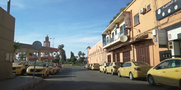
Bronwen Powell in Morocco shares this photo she recently took (from the car) on her way home from the supermarket. “There are rows and rows of taxis parked along the streets beside the bus station near the famous Koutoubia mosque in central Marrakech. This time of year is normally the peak tourist season and it is often very difficult to flag a taxi,” she said.

GOOD NEWS

Jianfan Yang received a box of 450 N95 masks from his relatives and was able to donate the masks to Mt. Nittany Medical Center.

Marie Louise Ryan received the Graduate Student International Research Award.

A class project in GEOG 586 in the online MGIS program has been accepted for publication in PlosOne. Blanford, J.I., T. Belcher, T. Black, E. Derner, J. Dunham, E. Galvan Campanero, M. Gority, R. Jones, B. Kaley, J. Kuli, R. Ligon, E. Mandal, T. Quink, J. Shinsky, M. Sodek, N. Teigland, and S. Turne collaborated on, “Pedal Power: Explorers and commuters of New York Citi Bikesharing scheme.”

Hannah Schreck was named a spring 2020 EMSAGE Laureate.

Working Remotely with Geospatial Data and Mapping Projects online session will introduce graduate students to geospatial data from U.S. and international sources, along with information on geospatial software access at Penn State including ArcGIS Online, ArcGIS ArcMap, and ArcGIS Pro. 3 p.m. on Friday, May 15, 2020.

Esri Offers Students Free Access to Software through August 31.

NEWS

USGIF Announces K. Stuart Shea Endowed Scholarship Recipient

The United States Geospatial Intelligence Foundation (USGIF) recognized Wendy L. Zeller Zigaitis, a Pennsylvania State University (PSU) Ph.D. student, as the 2020 recipient of the Foundation’s K. Stuart Shea Endowed Scholarship.

RECENTLY PUBLISHED

Virtual reality for student learning: Understanding individual differences

Li, P., Legault, J., Klippel, A., & Zhao, J.
Human Behaviour and Brain
https://doi.org/10.37716/HBAB.2020010105
Virtual reality (VR) is emerging as a rapidly developing technology that holds significant promises to impact student learning. In this review, we focus on the features of this technology regarding levels of immersion and interaction and individual differences in cognitive characteristics of VR learners. We attempt to parse the specific technological features that enable effective learning and examine how students mentally process these features. While VR helps to create situated learning conditions, its theoretical significance lies in its ability to provide perception-action enabled experiences to the learner, and it is these experiences that lead to positive behavioural and brain outcomes compared to traditional methods of learning. Our discussion highlights the understanding of VR learning with respect to individual differences, especially in spatial abilities of the learner, and how variability in spatial abilities might impact both spatial learning and language learning.


21
Apr 20

Geography’s GEMS | Zeller Zigaitis gets USGIF scholarship | AAG virtual sessions available

IMAGE OF THE WEEK

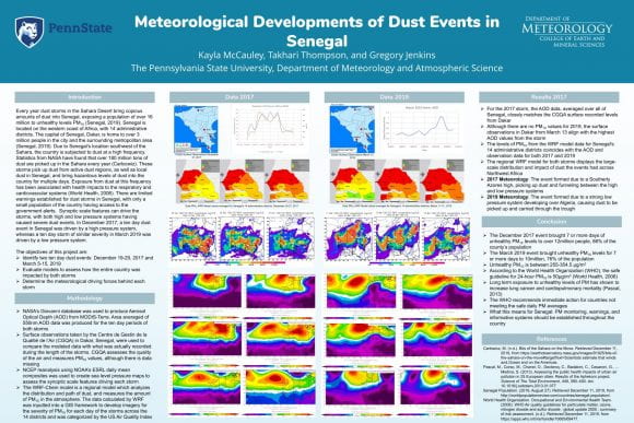
winning CUE posterTakhari Thompson and Kayla McCauley (Meteorology and Atmospheric Science) won best poster in the 2020 Celebration of Undergraduate Engagement Awards for “Meteorological Developments of Dust Events in Senegal.” Additional participants included Xintong Guan and Jianfan Yang and Harman Singh. See all entries here.

GOOD NEWS

Wendy Zeller Zigaitis was named as the recipient of the Stu Shea Endowed Scholarship from the United States Geospatial Intelligence Foundation.

Helen Greatrex joined the World Meteorological Organization WMO Societal and Economic Research Applications (SERA) Working Group and attended her first meeting in April.

Helen Greatrex was awarded a Corporate Social Responsibility grant by the global insurer and reinsurer, AXA-XL.

The Institutes of Energy and the Environment is holding a workshop on Climate and Carbon Challenges at Penn State. Wednesday, April 22, 2020, at noon. Join via zoom: https://psu.zoom.us/webinar/register/WN_ixsWkk6HRFihEVKCgjlsvA

Access session videos from the AAG virtual meeting. Were you unable to attend some of the live sessions? Most sessions were recorded and videos are now viewable in our online session gallery through May 14.

Penn State Alumni Association offering complimentary three months of membership to any Penn Stater who opts in through May 4.

NEWS

Geography’s board representatives strengthen connections to alumni

The Department of Geography has three representatives serving on the Graduates of the Earth and Mineral Sciences (GEMS) board this year: Emily Starin Connor who earned a bachelor of science in 2012 and now works as an associate with CleanCapital; Susan Lechtanski, who earned a bachelor of science in 1997 and now works as a project manager for Penn State Auxiliary and Business Services; and Wendy Zeller Zigaitis, who earned a bachelor of science in 1999 and is currently a doctoral student.

Esri Press e-books access for students at no charge

To support distance learning during the coronavirus disease 2019 (COVID-19) crisis, Esri Press e-books are now available at no charge to students through the VitalSource Helps program until May 25, 2020.

  • Students must be enrolled in a 2-year or 4-year college or university.
  • Students can access to up to 7 titles of their choice.
  • They must sign up with VitalSource and access e-books through Bookshelf using their school-assigned email address.

Students are being provided access now through May 25, 2020. After that, any e-books will disappear from their Bookshelf library.

RECENTLY PUBLISHED

A Comparison of Visual Attention Guiding Approaches for 360°Image-Based VR Tours

Jan Oliver Wallgrün, Mahda M. Bagher, Pejman Sajjadi, Alexander Klippel
Proceedings: 2020 IEEE Conference on Virtual Reality and 3D User Interfaces (VR)
https://conferences.computer.org/vr-tvcg/2020/pdfs/ VR2020-2f8MzUJjtCXG6Ue9RYFSN2/560800a083/560800a083.pdf
Mechanisms for guiding a user’s visual attention to a particular point of interest play a crucial role in areas such as collaborative VR and AR, cinematic VR, and automated or live guided tour experiences in xR-based education. The attention guiding mechanism serves as a communication tool that helps users find entities currently not visible in their view, referenced for instance by another user or in some accompanying audio commentary. We report on a user study in which we compared three different visual guiding mechanisms (arrow, butterfly guide, and radar) in the context of 360°image-based educational VR tour applications of real-world sites. A fourth condition with no guidance tool available was added as a baseline. We investigate the question: How do the different approaches compare in terms of target finding performance and participants’ assessments of the experiences. While all three mechanisms were perceived as improvements over the no-guidance condition and resulted in significantly improved target finding times, the arrow mechanism stands out as the most generally accepted and favored approach, whereas the other two (butterfly guide and radar) received a more polarized assessment due to their specific strengths and drawbacks.


14
Apr 20

Dowler receives award | Virtual commencement | COVID-19 grants

IMAGE OF THE WEEK

tree

Although Penn State’s University Park campus remains quiet, hopeful signs of spring are beginning to bloom. See a photo gallery of spring blooms.

GOOD NEWS

Lorraine Dowler has been awarded the 2020 Jan Monk Service Award from the AAG Feminist Geographies Specialty Group.

The EarthTalks seminar will be held at 4 p.m. Monday, April 20. David Yoxtheimer will discuss the science and technology of shale energy development, and how to combine research, policy and technology to mitigate the environmental issues while meeting society’s energy. Zoom at https://psu.zoom.us/j/594342606. The talk is free and open to the public.

April 22, 2020 will mark 50 years of Earth Day.  In honor of the 50th Anniversary of Earth Day, The GREEN Program will be hosting a virtual panel series to catalyze dynamic conversations around sustainability topics.

CORONAVIRUS INFORMATION
AND RESOURCES

NEWS

Penn State to recognize class of 2020 with virtual commencement ceremony

In response to the growing coronavirus pandemic, orders from the state government and recommendations from global public health organizations, Penn State will hold its spring 2020 commencement ceremony via livestream on May 9. The virtual ceremony will recognize all Penn State undergraduate students and all graduate students in the Penn State Graduate School.

Explore Grants to help researchers search for COVID-19 solutions

Penn State researchers interested in using computational resources to address the COVID-19 pandemic are encouraged to apply for support through the Institute for Computational and Data Sciences’ (ICDS) Explore Grant program.

From the esri ArcGIS Blog

Virtualization of ArcGIS from the Cloud and On-Premise platforms to support Higher Education

The coronavirus (COVID-19) is causing many universities and colleges to virtualize their classes.  Schools that have not considered or postponed a decision to virtualize their GIS classes using ArcGIS Pro and ArcMap are revaluating their options.  Those that have experimented with virtualizing ArcGIS Pro are seriously considering how to expand their virtualized offering.

RECENTLY PUBLISHED

Book Review: Re-enchanting the World: Feminism and the Politics of the Commons

Jacklyn Weier
The AAG Review of Books
DOI: 10.1080/2325548X.2020.1722464
This edited collection by Italian feminist, scholar, and activist Silvia Federici features writings published in various venues over the course of her career. In essence, the collected writings trace the entanglement of capitalism, women’s reproductive work, the burgeoning debt crisis, and the commons. With a foreword by Peter Linebaugh, and publications from the 1980s to the present, Re-enchanting the World: Feminism and the Politics of the Commons offers a view of Federici’s previous work that argues for its continued importance and relevance in the world. Although Federici is most known for her book Caliban and the Witch: Women, the Body and Primitive Accumulation (Federici 2004), as well as her publications demonstrating the connections between sexuality and reproductive work, Re-enchanting the World offers a renewed perspective on some of the other key theories and ideologies Federici has delved into throughout her career. The inclusion and ordering of her previous publications successfully place her work among larger discussions concerning Marxist accumulation, the political importance of the commons, and the role of debt in capitalism and the creation of the proletariat.

Coming Out of the Foodshed: Phosphorus Cycles and the Many Scales of Local Food

Russell C. Hedberg II
Annals of the American Association of Geographers
DOI: 10.1080/24694452.2019.1630248
Systems of food production and provision face a set of complex and interdependent challenges to sustainably meet current and future nutrition needs and minimize the negative social and ecological consequences of modern agriculture. Food system localization, often in the context of specific initiatives like farmers’ markets, are frequently put forth as a promising strategy for establishing more just food systems and agroecological production that relies on regional resources and in situ ecological processes rather than agrichemical inputs. Despite a significant literature on local food, there remain critical omissions in geographic inquiry, particularly analyses of scale in regard to food system localization. This article uses scale as an analytical lens to examine phosphorus fertility on farms participating in a farmers’ market network in New York City. Through a synthesis of biogeochemical analysis, semistructured interviews, and nutrient network mapping, the work charts the complex and often contradictory interactions of material and discursive scales in local food systems. The lens of scale reveals multiple narratives of sustainability, indicating both the great potential for agroecological phosphorus management and significant structural problems that undermine the project of food system localization. These findings argue for a more expansive approach to localization that acknowledges a mosaic of overlapping scalar processes in food systems and that the sustainability promise of food system localization requires interconnected sustainabilities in multiple places and at multiple scales.

“The Care and Feeding of Power Structures”: Reconceptualizing Geospatial Intelligence through the Countermapping Efforts of the Student Nonviolent Coordinating Committee

Joshua F. J. Inwood & Derek H. Alderman
Annals of the American Association of Geographers
DOI: 10.1080/24694452.2019.1631747
This article advances three interrelated arguments. First, by focusing on the Student Nonviolent Coordinating Committee’s (SNCC) Research Department, an undertheorized chapter in the civil rights movement, we advance an expressly spatialized understanding of the African American freedom struggle. Second, by focusing on an SNCC-produced pamphlet titled The Care and Feeding of Power Structures, we advance a larger historical geography of geospatial agency and countermapping of racial capital within black civil rights struggles. SNCC’s research praxis, which we argue constitutes a radical geospatial intelligence project, recognizes that geographical methods, information, and analytical insights are not just the purview of experts but are a set of political tools and processes deployed by a wide range of groups. Our article develops a deeper understanding of the rich spatial practices underlying black geographies and the role of geospatial intelligence in a democratic society outside the military–industrial–academic complex.

Racial/ethnic segregation and health disparities: Future directions and opportunities.

Yang, T‐C, Park, K, Matthews, SA.
Sociology Compass
https://doi.org/10.1111/soc4.12794
Health researchers have investigated the association between racial segregation and racial health disparities with multilevel approaches. This study systematically reviews these multilevel studies and identifies broad trends and potential directions for future research on racial segregation and health disparities in the US. After searching databases including CINAHL and MEDLINE, we systematically reviewed 66 articles published between 2003 and 2019 and found four major gaps in racial/ethnic segregation and health disparities: (a) the concept of segregation was rarely operationalized at the neighborhood level, (b) except for the evenness and exposure dimension, other dimensions of segregation are overlooked, (c) little attention was paid to the segregation between whites and non‐black minorities, particularly Hispanics and Asians, and (d) mental health outcomes were largely absent. Future directions and opportunities include: First, other segregation dimensions should be explored. Second, the spatial scales for segregation measures should be clarified. Third, the theoretical frameworks for black and non‐black minorities should be tested. Fourth, mental health, substance use, and the use of mental health care should be examined. Fifth, the long‐term health effect of segregation has to be investigated, and finally, other competing explanations for why segregation matters at the neighborhood level should be answered.

07
Apr 20

AAG virtual meeting this week | COVID-19 dashboard for PA | Students connect online

IMAGE OF THE WEEK

screenshot-COVID-19 dashboard

Pennsylvania COVID-19 online dashboard created by the Donald W. Hamer Center for Maps and Geospatial Information. The dashboard, which is updated manually two hours after the Pennsylvania Department of Health Cases Table is updated, provides a map of the state with the number of confirmed COVID-19 cases represented by county. See the story below.

GOOD NEWS

AAG is facilitating a virtual annual meeting April 6-10, in response to restrictions on travel and gathering during the COVID-19 pandemic. The virtual conference will offer more than 130 sessions and panels. The link for the Session Gallery is on the Department of Geography homepage for the week. Go to the Session Gallery

The Graduate School will host a virtual town hall at 4:30 p.m. on Thursday, April 9, at https://liveevents.psu.edu to provide updates and answer graduate students’ questions about the school’s response to the novel coronavirus pandemic.

Emily Rosenman is hosting a virtual happy hour for womxn in economic geography on Friday, April 10, coinciding with the AAG virtual meeting. The gathering is a welcoming space where women-identified and non-binary scholars of the economy, broadly understood, can build connections across intellectual traditions, topics of study and theoretical orientations. For more information and to RSVP

The Ecology Institute announced a call for proposals for its Flower Grant program. The funds aim to support ecology research focused across the institute’s five core themes: resilience and adaptation; provision of ecosystem goods and services; ecology at the interface; rapid evolutionary change; and ecological foundations. The application process and details about the program are available on InfoReady. Questions not answered by the InfoReady page can be sent to Smithwick at smithwick@psu.edu.

CORONAVIRUS INFORMATION
AND RESOURCES

NEWS

Online dashboard enables COVID-19 tracking by Pennsylvania county

Residents of Pennsylvania can monitor the spread of COVID-19 across the commonwealth with an online dashboard created by researchers at Penn State. The dashboard, which has been available since March 12, provides a map of the state with the number of confirmed COVID-19 cases represented by county.

Students keep learning communities alive virtually

The halls and classrooms of Walker Building are empty and silent but undergraduate and graduate students in the Department of Geography are finding ways to connect and support each other during remote learning. The students are holding virtual meetings to provide both academic and social support.

Drifting With Broken Sea Ice

In September 2019, the German research icebreaker Polarstern left Norway and cruised toward the heart of the Arctic Ocean. The purpose: Spend a year frozen into the sea ice while scientists onboard make measurements of the effects of climate change. Now about halfway through the Multidisciplinary drifting Observatory for the Study of Arctic Climate (MOSAiC) expedition, the icebreaker has weathered the dark polar winter and daylight has started to return.

RECENTLY PUBLISHED

From the School Yard to the Conservation Area: Impact Investment across the Nature/Social Divide

Cohen, D. and Rosenman, E.
Antipode
doi:10.1111/anti.12628
In the face of planetary crises, from inequality to biodiversity loss, “impact investing” has emerged as a vision for a new, “moral” financial system where investor dollars fund socio‐environmental repair while simultaneously generating financial returns. In support of this system elite actors have formed a consensus that financial investments can have beneficial, more‐than‐financial outcomes aimed at solving social and environmental crises. Yet critical geographers have largely studied “green” and “social” finance separately. We propose, instead, a holistic geography of impact investing that highlights the common methods used in attempts to offset destructive investments with purportedly reparative ones. This involves interrogating how elite‐led ideas of social and environmental progress are reflected in investments, as well as deconstructing the “objects” of impact investments. As examples, we use insights from both “green” and “social” literatures to analyse the social values embedded in projects of financialisation in schooling and affordable housing in the US.

Exploring the Effects of Geographic Scale on Spatial Learning

Jiayan Zhao, Mark Simpson, Jan Oliver Wallgrün, Pejman Sajjadi & Alexander Klippel
Cognitive Research: Principles and Implications
 https://doi.org/10.1186/s41235-020-00214-9
Investigating the relationship between the human body and its spatial environment is a critical component in understanding the process of acquiring spatial knowledge. However, few empirical evaluations have looked at how the visual accessibility of an environment affects spatial learning. To address this gap, this paper focuses on geographic scale, defined as the spatial extent visually accessible from a single viewpoint. We present two experiments in which we manipulated geographic scale using two perspectives, a ground level and an elevated view, in order to better understand the scale effect on spatial learning. Learning outcomes were measured using estimates of direction and self-reports of mental workload. In contrast to our hypothesis, we found few differences in spatial learning when comparing different perspectives. However, our analysis of pointing errors shows a significant interaction effect between the scale and spatial ability: The elevated perspective reduced the differences in pointing errors between low and high spatial ability participants in contrast to when participants learned the environment at ground level alone. Bimodal pointing distributions indicate that participants made systematic errors, for example, forgetting turns or segments. Modeling these errors revealed a unified alternative representation of the environment and further suggests that low spatial ability participants benefited more from the elevated perspective in terms of spatial learning compared to high spatial ability participants. We conclude that an increased geographic scale, which was accessible through an elevated perspective in this study, can help bridge the performance gap in spatial learning between low and high spatial ability participants.

Making an Anthropocene Ocean: Synoptic Geographies of the International Geophysical Year (1957–1958)

Jessica Lehman
Annals of the American Association of Geographers
DOI: 10.1080/24694452.2019.1644988
Although the notion of the Anthropocene has generated a great deal of literature across disciplines, the geographic critique of this concept is still developing. This article contributes to justice-oriented engagements with the Anthropocene by highlighting the relationships through which planetary knowledge is constructed as sites of critique. I develop an analytic of synoptic geographies, which addresses the praxis of coordinated field measurements that creates the planetary knowledge on which concepts of the Anthropocene rest. Synoptic geographies require a geographic analytic that is capable of going beyond assertions that all knowledge is local. The International Geophysical Year (IGY; 1957–1958) provides a strategic opportunity to elaborate the stakes of synoptic geographies. The IGY was arguably the first attempt to understand the Earth as a planet through a program of widespread synoptic data collection. In particular, the synoptic geographies of the IGY’s oceanography program reveal the ways in which old and new forms of imperialism were knitted together to produce the world ocean as an object of knowledge in a new era of planetary-scale environmental politics.


Skip to toolbar