28
Sep 21

Lechtanski GEMS president-elect | EMS Photoshoots | Undergrad interns at investment office

IMAGE OF THE WEEK

Tri and Luke CH924

Coffee Hour speaker Rajashree (Tri) Datta, research associate in the Ice Sheets and Climate Group at Colorado University Boulder, left, with Luke Trusel, speakers committee co-chair and assistant professor of geography, at the Sept. 24 Coffee Hour. The next Coffee Hour is Friday, Oct. 8. Recorded talks can be viewed on the Coffee Hour Kaltura channel. Image: Penn State.

GOOD NEWS

EMS faculty, staff, and students walk-in photoshoots will take place outside the main entrance to the Deike Building that faces Burrowes Road. Sessions will take less than five minutes. No appointment needed. If you have questions, contact David Kubarek [dak207@psu.edu]. Sessions are scheduled for the following dates:

  • Wednesday, Sept. 29: noon–2 p.m.
  • Wednesday, Oct. 6: 2 –4 p.m.
  • Thursday, Oct. 7: 11 a.m.–1 p.m.

Monday, Oct. 4, 4 p.m. ET, EESI EarthTalks, “Viewing the 2019–20 Australian bushfire crisis through a pyrogeographic lens,” with speaker David Bowman, University of Tasmania. Zoom webinar: https://psu.zoom.us/s/767635597

The Cartography and Geographic Information Society CaGIS announces its 49th Annual Map Design Competition. The competition is open to all mapmakers in the United States and Canada for maps completed or published during the calendar year of 2021.

Erica Smithwick was a guest on the Sept. 26 episode of President Eric Barron’s monthly WPSU show, “Digging Deeper” on the topic of climate change.

Alumna Susan Lechtanski, who earned a bachelor of science in 1997, and is one of three geography representatives on the Graduates of the Earth and Mineral Sciences (GEMS) board, was voted President-Elect of the board.

COFFEE HOUR

Next lecture is Friday, Oct. 8

Spatial Networks: The synergy of computational geography and geospatial Big Data for uncovering geo-complexity in human-urban environment interactions

Junjun Yin, Assistant Research Professor, Social Science Research Institute (SSRI)

Previously recorded talks can be viewed on the Coffee Hour Kaltura channel.

NEWS

Department associate heads appointed to amplify diversity efforts in EMS

Lorraine Dowler is the DEI  associate head in the Department of Geography

Furthering its mission to support diversity, equity and inclusion (DEI), the College of Earth and Mineral Sciences (EMS) has provided funding for each of its five departments to appoint faculty to serve as DEI associate heads.

Economics, geography students intern with Penn State’s investment office

Prior to her internship with Penn State’s Office of Investment Management, Morgan Keim, a Dalmatia, Pennsylvania, native and senior majoring in economics, did not know what her future held. After her remote internship experience this summer, that is no longer the case.

Alongside Keim was Jacqueline Saleeby, a State College, Pennsylvania, native and senior majoring in geography with a minor in Arabic. The pair spent 14 weeks researching the integration of environment, social and governance practices, known as ESG for short, across the investment industry while recommending potential strategies for inclusion in the office’s investment process.

RECENTLY PUBLISHED

Soil moisture influence on warm-season convective precipitation for the U.S. Corn Belt

Chapman, C. J., & Carleton, A. M.
Journal of Applied Meteorology and Climatology
https://doi.org/10.1175/JAMC-D-20-0285.1
Recent climatic studies for the dominantly rain-fed agricultural U.S. Corn Belt (CB) suggest an influence of land use/land cover (LULC) spatial differences on convective development, set within the larger-scale (synoptic) atmospheric conditions of pressure, winds, and vertical motion. However, the potential role of soil moisture (SM) in the LULC association with atmospheric humidity, horizontal wind and convective precipitation (CVP) has received more limited attention, mostly as modeling studies or empirical analyses for regions non-analogous to the CB. Accordingly, we determine the categorical associations between SM and the near-surface atmospheric humidity (q), with 850-hPa horizontal wind (V850) at four representative CB locations for the nine warm-seasons of 2011-2019. Recurring configurations of joint SM-q-V850 conducive to CVP are then identified and stratified into three phenologically distinct sub-seasons (early, middle, late).

We show that the stations show some statistical similarity in their SM-CVP relationships. Corn Belt CVP occurs preferentially with high humidity and southerly winds sometimes comprising a low-level jet (LLJ), particularly on early-season days having low SM and late-season days having high SM. Additionally, mid-season CVP days having weaker V850 (i.e., non-LLJ) tend to be associated with medium SM values and high humidity. Conversely, late-season CVP days are frequently characterized by high values of both SM and humidity. These empirical results are likely explained by the inferred sensible and latent heat fluxes varying according to SM content and LULC type. They provide a basis for future mesoscale modeling studies of Corn Belt SM and CVP interactions to test the hypothesized physical processes.


21
Sep 21

Coffee Hour with Tri Datta | Fall Coffee Hour speakers | EMS Anniversary Fellows

IMAGE OF THE WEEK

Holmes and Randell

Louisa Holmes, assistant professor of geography, left, with speaker Heather Randell, assistant professor of rural sociology and demography, at the Sept. 10 Coffee Hour.   Recorded talks can be viewed on the Coffee Hour Kaltura channel. Image: Penn State

GOOD NEWS

COFFEE HOUR

Rajashree (Tri) Datta on Extreme Events on the Antarctic and Greenland Ice Sheets

Sea level change is partly determined by the balance between precipitation and surface melt and subsequent meltwater runoff on the Greenland and Antarctic Ice Sheets. Both ice sheet precipitation and melt occur relatively infrequently, but extreme events can have a disproportionate impact on the ice sheet system. In this talk I will highlight three different extreme phenomena and their impact, which I have studied using a combination of climate modeling and remote sensing.

NEWS

Speakers for fall Department of Geography Coffee Hour lecture series announced

The Department of Geography Coffee Hour lecture series has resumed on Friday afternoons for the fall 2021 semester on Penn State’s University Park campus.

2011 article, “SensePlace2 GeoTwitter analytics support for situational awareness,” wins Test of Time Award

The IEEE VIS Test of Time Award is an accolade given to recognize articles published at previous conferences whose contents are still vibrant and useful today and have had a major impact and influence within and beyond the visualization community.

125th Anniversary Fellows named by the College of Earth and Mineral Sciences

Geography alums among the Fellows

Founded in 1896 as the School of Mines, this year, the College of Earth and Mineral Sciences is celebrating its 125th anniversary. The college recognizes that the success and reputation of the college is defined substantially by the achievements of its graduates. To honor their accomplishments the college has selected a prominent group of 134 alumni whose contributions to the fields of science and engineering have set them apart from their peers and named them 125th Anniversary Fellows.

RECENTLY PUBLISHED

Interactions between landscape and local factors inform spatial action planning in post-fire forest environments

Peeler, J.L., Smithwick, E.A.H.
Landscape Ecology
https://doi.org/10.1007/s10980-021-01325-4

Context: Landscape and local factors govern tree regeneration across heterogeneous post-fire forest environments. But their relative influence is unclear—limiting the degree that managers can consider landscape context when delegating resources to help stand-replacing patches restock successfully.

Objectives: We investigated how landscape and local factors shape tree regeneration across heterogeneous post-fire forest environments. Our research questions were: What is the relative influence of landscape and local factors on tree species presence (RQ1) and stocking density (RQ2) at stand-replacing patches? Do thresholds occur when landscape factors are influential (RQ3)?

Methods: We sampled landscape and local variables at 71 plots near Jackson, Wyoming, United States. We used Random Forests to investigate how local and landscape variables affect post-fire tree recovery. Relative influence was determined using mean decrease in accuracy. Partial dependence plots were used to visualize whether thresholds occurred for variables with mean decrease in accuracy > 15%.

Results: Landscape factors like seed source area were associated with subalpine fir presence and stocking density. But different thresholds occurred. Specifically, subalpine fir presence required 10% seed source area, while stocking density required 40%. Northeast aspects surrounded by > 10% seed source area were most likely to support subalpine fir presence. Conversely, local factors like soil nutrients were associated with lodgepole pine presence, highlighting effects of different regeneration strategies.

Conclusions: Landscape factors bolster spatial resilience and help stand-replacing patches restock naturally. But landscape factors do not support tree regeneration equally across heterogeneous post-fire forest environments. Consequently, considering stand-replacing patches in their landscape context will be critical for future spatial action planning.

Future Sea Level Change Under Coupled Model Intercomparison Project Phase 5 and Phase 6 Scenarios From the Greenland and Antarctic Ice Sheets

Antony J Payne, Sophie Nowicki,  … Luke D. Trusel … et al.
Geophysical Research Letters
https://doi.org/10.1029/2020GL091741
Projections of the sea level contribution from the Greenland and Antarctic ice sheets (GrIS and AIS) rely on atmospheric and oceanic drivers obtained from climate models. The Earth System Models participating in the Coupled Model Intercomparison Project phase 6 (CMIP6) generally project greater future warming compared with the previous Coupled Model Intercomparison Project phase 5 (CMIP5) effort. Here we use four CMIP6 models and a selection of CMIP5 models to force multiple ice sheet models as part of the Ice Sheet Model Intercomparison Project for CMIP6 (ISMIP6). We find that the projected sea level contribution at 2100 from the ice sheet model ensemble under the CMIP6 scenarios falls within the CMIP5 range for the Antarctic ice sheet but is significantly increased for Greenland. Warmer atmosphere in CMIP6 models results in higher Greenland mass loss due to surface melt. For Antarctica, CMIP6 forcing is similar to CMIP5 and mass gain from increased snowfall counteracts increased loss due to ocean warming.


14
Sep 21

Fowler on redistricting council | Trusel measures Greenland ice | Schuckman named ASPRS exec. dir.

IMAGE OF THE WEEK

West Greenland ice cap

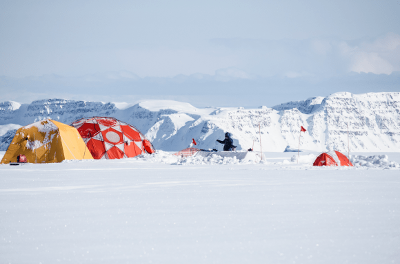
Luke Trusel configures equipment to measure sub-surface temperatures in the West Greenland ice cap. Image: Sarah Das ©Woods Hole Oceanographic Institution.

GOOD NEWS

Monday, September 20, 4 p.m. ET, EESI Earthtalks “Examining climate-human-fire interactions and feedbacks in temperate ecosystems,” David McWethy, Montana State University. Zoom webinar: https://psu.zoom.us/s/767635597

Friday, October 1, 5 p.m. ET, deadline for undergraduate and graduate student fall academic enrichment award applications. Apply using this link: https://sites.psu.edu/geogcommunity/academic-enrichment-request-form/

Connor Chapman and Andrew Carleton’s article based on Chapman’s master’s thesis, “Soil moisture influence on warm-season convective precipitation for the U.S. Corn Belt,” was accepted for publication in the Journal of Applied Meteorology and Climatology.

Erica Smithwick was appointed to Penn State’s Carbon Emissions Reduction Task Force. https://news.psu.edu/story/668103/2021/09/03/impact/task-force-created-significantly-reduce-penn-states-carbon-emissions

Karen Schuckman was appointed as the next executive director of the American Society for Photogrammetry and Remote Sensing (ASPRS).

The fall semester Coffee Hour schedule has been announced. For speakers and dates, visit the calendar of events web page.

NEWS

Governor Wolf Creates Redistricting Advisory Council to Help Evaluate Fairness in Upcoming Congressional Redistricting Map

Christopher S. Fowler is a member of the council

Governor Tom Wolf is committed to a fair and transparent redistricting process and today signed an executive order creating the Pennsylvania Redistricting Advisory Council. The six-member council, comprised of redistricting experts, will provide guidance to the governor to assist his review of the congressional redistricting plan which will be passed by the General Assembly later this year.

Tracking Traits Podcast: Evolutionary Drivers of our Taste Preferences for Vegetables

Bronwen Powell is interviewed

Penn State undergraduate student Hannah Marchok interviews Assistant Professor of Geography, African Studies, and Anthropology Bronwen Powell about her research into factors that may drive dietary practices across different groups of people in different regions of East Africa.

A Recent Reversal Discovered in the Response of Greenland’s Ice Caps to Climate Change

Luke Trusel is a member of the research team

New collaborative research from the Woods Hole Oceanographic Institution and five partner institutions (University of Arizona, University of Washington, Pennsylvania State University, Desert Research Institute and University of Bergen), published on September 9, 2021, in Nature Geoscience, reveals that during past periods glaciers and ice caps in coastal west Greenland experienced climate conditions much different than the interior of Greenland. Over the past 2,000 years, these ice caps endured periods of warming during which they grew larger rather than shrinking.

Past fires may hold key to reducing severity of future wildfires in western US

Previous fires may hold the key to predicting and reducing the severity of future wildfires in the western United States as fire activity continues to increase, according to researchers from Penn State and the U.S. Forest Service.

RECENTLY PUBLISHED

Determinants of Smallholder Maintenance of Crop Diversity in Morocco’s High Atlas Mountains

Zachary A. Goldberg, Bronwen Powell, Abderrahim Ouarghidi
Human Ecology
https://doi.org/10.1007/s10745-021-00248-7
Smallholder farmers are important managers of global crop diversity. However, agricultural modernization is changing farming practices and raising questions about the socio-ecological factors that support crop diversity. In the context of the semi-arid High Atlas Mountains in Morocco, we explored determinants of crop diversity through a cross-sectional survey and farmer interviews in villages adopting new crops such as apples. Through a multiple linear regression analysis and farmer interviews, we found that market participation, land holdings, and water access influenced crop diversity. We highlight the importance of water access for crop diversity, especially in semi-arid regions with uneven hydrological resources.

Interpretable machine learning for analysing heterogeneous drivers of geographic events in space-time

Arif Masrur, Manzhu Yu, Prasenjit Mitra, Donna Peuquet & Alan Taylor (2021)
International Journal of Geographical Information Science
DOI: 10.1080/13658816.2021.1965608
Machine learning (ML) interpretability has become increasingly crucial for identifying accurate and relevant structural relationships between spatial events and factors that explain them. Methodologically aspatial ML algorithms with an apparent high predictive power ignore non-stationary domain relationships in spatio-temporal data (e.g. dependence, heterogeneity), leading to incorrect interpretations and poor management decisions. This study addresses this critical methodological issue of ‘interpretability’ in ML-based modeling of structural relationships using the example of heterogeneous drivers of wildfires across the United States. Specifically, we present and evaluate a spatio-temporally interpretable random forest (iST-RF) that uses spatio-temporal sampling-based training and weighted prediction. Although the ultimate scientific objective is to derive interpretation in space-time, experiments show that iST-RF can improve predictive accuracy (76%) compared to the aspatial RF approach (70%) while enhancing interpretations of the trained model’s spatio-temporal relevance for its ensemble prediction. This novel approach can help balance prediction and interpretation with fidelity in a spatial data science life cycle. However, challenges exist for predictive modeling when the dataset is very small because in such cases locally optimized sub-model’s prediction performance can be suboptimal. With that caveat, our proposed approach is an ideal choice for identifying drivers of spatio-temporal events at country- or regional-scale studies.

Land use change dynamics in Euro-mediterranean mountain regions: Driving forces and consequences for the landscape

Yolanda Jiménez-Olivencia, Álvaro Ibáñez-Jiménez, Laura Porcel-Rodríguez, Karl Zimmerer
Land Use Policy
https://doi.org/10.1016/j.landusepol.2021.105721
The marginalization of mountain regions in Mediterranean Europe since the mid-20th Century has triggered important socioeconomic and environmental changes that are putting the survival of highly regulated and environmentally adapted landscapes in jeopardy. We still have only a limited understanding of the driving forces behind these dynamics of change and their final consequences for the structure and character of the landscape. In general, the transformation of the landscape and its causes have been studied at regional and local level and various syntheses have been made for Europe or the Mediterranean as a whole, focusing above all on changes in the use of farmland. The objective of this paper is to provide a holistic view of the changes that have taken place in the landscape in the Euro-Mediterranean region, focusing in particular on the mountains because of their role as heritage reserves and as sources of environmental services. This research involves a systematic review of the evidence about the dynamics of land use change, its underlying drivers and their effects on the landscape. We analyse 53 case studies from 6 countries situated on the northern shores of the Mediterranean. These studies covered a period of around 40 years and were each performed at a local scale. The results reveal that landscape change is caused above all by the abandonment of farmland and reforestation (in over 90% of cases), and by pressure from urban development in the case of coastal and peri-urban mountain ranges. In addition, the dominant dynamics in each case vary depending on the bioclimatic area in question, to the extent that bioclimate has been shown to be an important explanatory factor behind these dynamics. The underlying boosters of change normally act together and those most commonly cited are economic, demographic and geographic. As regards the impacts on the structure and character of the landscape, the dynamics analysed are manifested first and foremost in degradation processes, in an increase in homogenization, which affects above all the most humid bioclimates, and in the fragmentation of open spaces. This analysis provides a general overview of the causes and consequences of the changes in land use in the mountain regions of Mediterranean Europe and raises questions of interest for policy-making that affects the landscape.

Drivers of fire severity shift as landscapes transition to an active fire regime, Klamath Mountains, USA

Taylor, A. H., L. B. Harris, and S. A. Drury
Ecosphere
https://esajournals.onlinelibrary.wiley.com/doi/pdfdirect/10.1002/ecs2.3734
Fire severity patterns are driven by interactions between fire, vegetation, and terrain, and they generate legacy effects that influence future fire severity. A century of fire exclusion and fuel buildup has eroded legacy effects, and contemporary fire severity patterns may diverge from historical patterns. In recent decades, area burned and area burned at high severity have increased and landscapes are transitioning back to an active fire regime where disturbance legacies will again play a strong role in determining fire severity. Understanding the drivers of fire severity is crucial for anticipating future fire severity patterns as active fire regimes are reestablished. We identified drivers of fire severity in the Klamath Mountains, a landscape with an active fire regime, using two machine learning statistical models: one model for nonreburns (n = 92) and one model for reburns (n = 61). Both models predicted low better than moderate or high-severity fire. Fire severity drivers contrasted sharply between non-reburns and reburns. Fire weather and fuels were dominant controls in non-reburns, while previous burn severity, fuel characteristics, and time since last fire were drivers for reburns. In reburns, areas initially burned at low (high) severity burned the same way again. This tendency was sufficiently strong that reburn fire severity could be predicted equally well with only severity of the previous fire in the model. Thus, reburn fire severity is more predictable than severity in non-reburns that are driven by the stochastic influences of fire weather. Reburn severity in aggregate was also higher than non-reburn severity suggesting a positive feedback effect that could contribute to an upward drift in fire severity as area burned increases. Terrain had low importance in both models. This indicates strong terrain controls in the past may not carry into the future. Low- and moderate-severity fire effects were prevalent in non-reburns under moderate fire weather and self-reinforcing behavior maintained these effects in reburns even under more extreme weather, particularly in reburns within 10 yr. Our findings suggest deliberate use of wildfire and prescribed fire under moderate conditions would increase fire resilience in landscapes transitioning to an active fire regime.


Skip to toolbar