Limitless Adventures in PA

P3120791

In my few months here in State College I have had the opportunity to partake in a lot of amazing adventures throughout Appalachia, from fishing for wild trout on crystal clear spring creeks, to spending a week in the wilderness of Northern Georgia, to snowshoeing in subzero temps in the Adirondack High Peaks, to cycling across the rolling farmland of Happy Valley. It seems the more time is spend outside the stronger my desire to wander gets. The best part is the number of places left to explore in the area are almost limitless.

image1 (3)

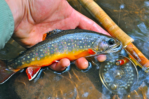
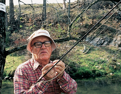
fly fishing the Little Juniata


Although I have spent much of my free time outdoors, I have not even scratched the surface of the amazing outdoor recreation opportunities that can be found around campus. Central PA is such an incredibly beautiful place, with diverse cultures, a long history and a plethora of cool places to see and things to do.

For example, this area of Pennsylvania has huge deposits of limestone, a calcium carbonate-based sedimentary rock that forms at the bottom of ancient seas. The valleys of Central PA have a soft limestone bedrock which means that they are particularly sensitive to erosion. Erosion of limestone underground caused by springs form caves, and Central Pennsylvania has some pretty incredible caves. I mentioned in an earlier post exploring Coonscat Cave, a wild cave located along route 192 near Centre Hall. This cave had some incredibly tight squeezes and was filled with thick, goopy, anaerobic mud. The nearby Penn’s Cave is a sharp contrast to Coonscat. It is a commercial cave meaning that it is privately owned and open for tours. It is several hundred feet long and has plenty of room for huge jon boats to lead tours through the caverns. The cave ceilings are almost 40 feet high in places and many of the cave formations are pristine and untouched. Penn’s creek flows through the cavern and gigantic rainbow trout over 2 feet long live in the cool, dark grotto. Another commercial cave is Indian Caverns, located just southeast of Happy Valley, in the town of Spruce Creek. Indian Caverns is the second biggest cave in the state and artifacts from the Susquehannock tribe have been found there dating back to 8000 BC.    Several times a year, Penn State Adventure Rec leads caving trips to local wild caves like Coonscat, Hipple, and other caverns across PA and West Virginia. The Nittany Grotto is a club devoted entirely to cave exploration and is open to novices.

Penn's Cave

Penn’s Cave

Central PA is also an incredible place for watersports. As I mentioned in earlier posts, the limestone spring creeks of PA are world renowned for their wild trout. Spring Creek, Penn’s Creek, LeTort Spring Run, the Little Juniata, and Yellow Breeches Creek are just a few. Lake Erie is one of the gems of our state. Erie provides wonderful steelhead, lake trout, walleye, and smallmouth bass fishing, as a matter of fact, according to In-Fisherman magazine, Lake Erie has the best Smallmouth Bass Fishing in the world. The Delaware River is one of the cleanest urban rivers in the world and I unique because it is one of the few undammed rivers remaining on the east coast. Above Trenton, the water quality is extremely high and the water is crystal clear. Atlantic Sturgeon (huge endangered prehistoric fish that can grow up to eight feet and 300 lbs) have made a comeback in the river in recent years as have striped bass.

In the mountains, there are several great whitewater rivers. The Upper Youghiogheny stands out as one of the best rafting rivers on the east coast, if not the country. It is the steepest commercially rafted river on the east coast, with a maximum gradient of 115 feet per mile. Parts of the 74 mile river are class V rapid meaning that it is one of the most challenging rivers in the country.

“The slide” on the Upper Yough

Pennsylvania is an incredible state. Here at Penn State University we are surrounded by picturesque countryside and limitless opportunities for outdoor adventure. This blog has documented some of my travels and hopefully has served as inspiration for my readers to get outside and enjoy some of what it has to offer. Perhaps you too suffer from the uncontrollable urge to push boundaries and explore some of what is out there.

I believe that we only protect what we love, and if we all spent more time in the outdoors, appreciating nature, we would feel a deeper obligation to protect this earth. Sadly, many areas of PA have been permanently harmed by agricultural pollution, strip mining and fracking. We have not learned from our long history of overexploiting resources and it is up to us, the next generation of Pennsylvanians, to put an end to the destruction and save Penn’s Woods for many years of adventures to come. Thank you for reading and see you all out there!

-Mike


bartram


http://www.prnewswire.com/news-releases/top-three-east-coast-river-rafting-spots-surge-into-spotlight-as-the-triple-crown-of-eastern-whitewater-52766112.html

http://en.wikipedia.org/wiki/Indian_Caverns


The Mid-State Trail- Pennsyltucky’s Best Kept Secret

Pennsylvania has been described as “Philadelphia and Pittsburgh with Kentucky in between” due to the rugged, scenic, and empty places of Central PA. Although Pennsylvania brags two of the most populous cities in the country, the state is truly characterized by small towns, rolling farmland, and miles of deep forests.

“Pennsylvania’s wildest trail”, the Mid State Trail, runs right through this wild corridor along high ridgelines, through groves of mountain laurel, and alongside crystal clear brooks. The trail is 523 km (325 miles) long and runs from the Mason Dixon Line all the way to the New York border near Lawrenceville, PA. The MST runs along the ridge just east of State College. The trail was originally a project of Penn State Students. In 1969, the PSU outing club began a project to create a trail across the “seven mountains” of Rothrock State Forest. The original trail spanned from the little Juniata River all the Way to R.B. Winter State Park and was maintained by Penn State Students, and the faculty advisor for the outing club, Tom Thwaites, a Physics Professor.

Indian Wells Vista on the MST, near State College

The Mid State Trail, along with some other PA state forest trails

Tom Thwaites was passionate about hiking and it showed. He was the face of the Penn State Outing Club for 29 years, and during his time he stressed giving back to the community by maintaining trails and constructing new ones. He emphasized the Mid State Trail as the Penn State Outing Club’s legacy which would live on for years and years to come. He dreamt that someday it would stretch from Maryland to New York, across a wide variety of landscapes that would provide a hiker with a view into the many different geological and biological regions of PA, from the laurel highlands of southcentral PA to the Pine forests of Tioga County.

Over time, as the trail grew, and Tom got older, it got to be too much for Penn State Students to maintain, so volunteer organizations like the Keystone Trail Association and others pitched in to build new trail and maintain existing ones. The trail was divided into four sections, the Everett Region to the south, the State College Region, the Woolrich region, and the Tioga region, in Northern PA. Each of these regions had their own volunteer trail crews to keep the trail up and running. As Tom reached the end of his life, the trail seemed to take on a life of its own, supported by both the Penn State community and communities all across the state. A long distance trail is not something that just happens, it is a living thing requires a lot of care and attention to keep it alive. Even today, sections of the trail are moved to prevent erosion, bridges are built, and a 12 mile section near Wellsboro, has yet to be constructed.

As Tom got older, he was comforted in the fact that even when he was gone, his legacy, the Mid State Trail would live on. He passed away on Christmas day in 2014 of heart failure at the age of 83. There is an engraved stone along the MST on Tussey ridge (the mountain visible from campus) at the intersection of the MST and the Kettle trail, where the first ridgeline bushwack took place, dedicated to the good work of Dr. Thwaites.

Tom with his trusty measuring wheel

His legacy, the MST, is one of the great, underrated gems of our area. The section of the trail near State College starts along the banks of the Little Juniata River and climbs over 1000 feet to the top of Tussey Ridge, which it follows for several miles. The high ridgeline, especially in winter provides amazing views. It then dips a few hundred feet into Pine Swamp before climbing back up to the high ridgeline, passing several gorgeous vistas, a stone “Roman Tower” built by the Penn State Outing Club, and the Little Flat Fire Tower  before cutting deep into Rothrock, crossing several ridgelines and route 322 at Seven Mountains Pass. Interestingly, because Tom Thwaites was a man of science, he insisted that all distances and altitudes on the trail be measured in meters and kilometers. Because of that, the trail is unique because it is one of the few trails in North America to use the metric system.

image1 (1)

Snowshoeing along Tussey Ridge


On a typical day on the Mid State, there are very few college students around and one has time to slow down and enjoy nature. Unlike other trails like the Appalachian Trail or the Mt. Nittany Trail, the MST is a little more secluded and secret. It is said that if you hike the MST, you’re bound to see more bears than people, which is how I think it should be.

There was a little poem called the Mid State Trail Song on the website for the MST and the final verse makes an appropriate tribute to Dr. Tom Thwaites, the father of the Mid State Trail, it goes like this;

With my boots and pack I’ll wander through the huckleberries blue,

‘Til I rest my soul on Big Flat with a bear to share the view.

Let me go to hikers heaven at the ending of my tale.

It will look like Pennsylvania, and I’ll hike the Mid State Trail.

image1 (2)

Sunset on the little flat fire tower

MST website – http://hike-mst.org/

http://www.legacy.com/obituaries/centredaily/obituary.aspx?pid=173658547

http://www.pahikes.com/hiking-info/general-info/599-a-history-of-the-mid-state-trail

Fairmount Park, the Queen of Urban Parks

Fairmount Park in 1900

After the country has been ravaged by several industrial booms during the eighteenth and nineteenth century, the cities were left in shambles. People moved from the countryside into cramped urban areas. The population of the cities outstripped the infrastructure. The working class were forced to live in crowded, disgusting hovels. Coal furnaces that powered textile mills and foundries spewed coal dust into the air and polluted rivers. Rivers were polluted and lifeless, filled with sewage and industrial waste.

The cities became so crowded that residents would go to cemeteries or any open lots of land to escape the noise of the city. City planners took notice of this and began to build the first urban parks in the US. In the mid 1800’s, many cities began beautification projects which included public parks. New York’s Central Park was constructed in 1857 by city planners Frederick Law Olmstead and Calvert Vaux. Olmstead and Vaux designed a series of urban parks across the country, including parts of Fairmount Park in Philadelphia.

Fairmount Park was in existence long before Olmstead and Vaux began work on improving the city park. The first tract of land was purchased in 1812 by the Philadelphia Water Works for the “health and enjoyment” of the citizens of Philadelphia. This 5 acre park was situated where the art museum is now, along the banks of the Schuylkill River. Fairmount Park was the first of its kind and huge step ahead in the world of urban planning.

Original park location, Philadelphia Museum of Art in the background, Water Works in the foreground

Over the years, Fairmount Park acquired more and more land and became an integral part of Philadelphia culture. The section of Fairmount along the Wissahickon Creek became a popular location for trout fishing as well as swimming. In 1821, the Fairmount Dam was constructed to keep tidal water from entering the city’s water source. The river’s rapids were submerged and the Schuylkill became a placid flat water river above the dam. The sport of rowing was popularized along this section of the River and thus began the cities long history of rowing. The famous boathouses along Kelly Drive were built during the 1800s by various rowing clubs as social gathering places and as places to store racing shells.

Some of the most famous Regattas in the world are held along the Fairmount Park section of the Schuylkill River including the Head of the Schuylkill, beginning in 1870, the Navy Day Regatta (both of which are held in the fall), the Stoatesbury cup, The Independence Day Regatta, and most famous of all, the Aberdeen Dad Vail Regatta. Each of these regattas hosts both high schools and colleges from around the area.

Boathouse Row

Turtle Rock Lighthouse and a two man racing scull

Fairmount Park is unique because of its age, its size, and its layout. It is a huge, sprawling park that follows the bank of the Schuylkill and other tributaries. It is larger than most urban parks and despite encroachments from builders and Schuylkill Expressway, it remains one of the most scenic and beautiful parks in a major US city. Today, the Schuylkill river greenway association continues to preserve land along the banks of the river for recreation and to ensure that the water stays clean. The Schuylkill River Trail is a trail system that runs over 100 miles into the countryside from Downtown Philly to Pottsville, with many side trails such as the Wissahickon and Perkiomen Trails in Montgomery County. Recently, the Schuylkill Banks boardwalk was built, a multipurpose walkway over the river in downtown Philadelphia with awesome views of the Philadelphia skyline.

The new Schuylkill Banks Boardwalk in downtown Philly

When it comes to urban parks, Philly does it right. Fairmount is minutes from one of the most populous cities in the US but it amazingly serene, clean and beautiful.

Opening day of trout season on the Wissahickon Creek

Opening day of trout season on the Wissahickon Creek

http://www.livingplaces.com/PA/Philadelphia_County/Philadelphia_City/Fairmount_Park.html

http://en.wikipedia.org/wiki/Fairmount_Park

http://www.visitphilly.com/articles/philadelphia/top-reasons-to-visit-the-awesome-new-schuylkill-banks-boardwalk/

Dark Skies, Bright Stars


The Milky Way as seen from Cherry Springs

Just North of State College is a region of PA known as the “Pennsylvania wilds” This area is mountainous and sparse, there are very few towns and huge expanses of wilderness. Whitetail Deer, Black Bear, Wild Turkey and Elk are abundant due to comparatively low hunting pressure. It is an incredibly special place because of the fact that it is so underused. Unlike Parks like Acadia, Great Smoky, or Yellowstone, north central PA does not attract many tourists, and for the most part the forests are deep, dark, and silent.

One area of the PA wilds known as the black forest is so far from civilization that it has almost no light pollution. Astronomers and amateur stargazers alike have been flocking to this remote part of Potter County since the mid 90s to experience the last dark place on the east coast. In Cherry Springs State Park, a 40 acre observation field was cleared in order to make room for stargazers. On a clear night, 50-100 people show up to see the stars and during meteorological events like meteor showers, hundreds upon hundreds of enthusiasts gather for “star parties” in the field.

Dark Sky Map of PA, Cherry Springs lies in the heart of the black dot in Potter County

Cherry Springs is classified as a “true dark sky”, a level 2 on the Bortle Dark-Sky scale. This is remarkable because dark skies are so rare in this part of the country due to the high population density of the eastern seaboard. As urban sprawl continues to spread our skies are becoming more and more polluted. 99% of the population of Europe and North America live in an area where they cannot see unpolluted starry skies at night. I feel as though seeing the stars at Cherry Springs is a way to escape to a time and place when man did not have as much of an impact on the earth. Dark skies also seem to be something incredibly fragile, something that many not be so readily viewable a few years down the road.

Typically there are around 60 clear nights a year at Cherry Springs, and very few of them occur in the winter. Cherry springs is exceptionally cold, snowy, and foggy in the winter. However, last Saturday night was cold, crisp and clear so my girlfriend and I decided to drive to see the stars at Cherry Springs.

We hiked on the Susquehannock trail to the Cherry Springs fire tower which provided an awesome view of the surrounding forest. As the sun went down the temperature began to drop. It was more than 20 degrees colder in the PA wilds than it was in State College so we decided to hike back to the car and sleep there rather than pitching a tent in the deep snow. We cooked dinner on the tailgate and watched as the stars came out. Even before the twilight had faded the sky was filled with hundreds of brilliant stars.

Cherry Springs is one of the few places in the Continental US one can go to see the Northern Lights

We fell asleep for a while and woke up at 2 am to see the stars. It was only about 5 degrees out and the car had frozen up so we put on all of our warmest clothing and sat up on the roof. What we saw amazed us. The sky was completely lit up by thousands of points of light. Easily identifiable constellations like the Big Dipper and Orion’s Belt were hard to see on account of the thousands of stars scattered across the sky like salt spilled on a black table cloth. Probably most impressive was the Milky Way. The Milky Way was an easily visible cluster of stars stretching across the night sky. The stars were so numerous that they blended together in places to form a continuous cluster of light.

Nowhere in my travels have I seen stars like the ones at Cherry Springs, the Black Forest of Pa is truly a special place and the night sky there is other worldly. Staying in Cherry Springs for a night of stargazing is a trip that all Penn Staters should experience.

http://www.dcnr.state.pa.us/stateparks/findapark/cherrysprings/

Georgia on My Mind

10419398_794535720634003_4145080356790149667_n

In a campsite atop a breezy, high ridgeline in Northern Georgia, eight Penn State students are enjoying their dinner of tuna mac and cheese, playing bananagrams and taking in the colors of a sunset at the end of a long day of hiking. At this point they are around ten miles from the closest road, they are four days into five day backpacking trip, and in that time have gone from complete strangers to close friends. As the last light fades from the rugged horizon, darkness settles upon the Blue Ridge Mountains and stars twinkle in the night sky. The nighttime chill does not keep the fearless eight from lying out under the stars to enjoy each other’s company in their last night in the backcountry.

During the hike, they’ve bonded with one another through the shared pain of hauling heavy backpacks on blistered feet through Georgia’s most remote and mountainous corridor. They’ve sung, told stories, laughed, cursed, and slept in unnaturally tight quarters. They’ve felt their interdependence, as not a single person carries all the necessary gear to survive out here. It is a bittersweet time, they would soon be back in “civilization” and their mindsets would transform back to the fast paced world of cell phones, cars and computers.

P3090214

cooking pasta in the woods


This is the experience that Penn State Adventure rec provided for twelve lucky students and four student guides on our spring break trip to the Bartram Trail in the Chattahoochee National Forest. Our route was remote and very scenic and we were blessed to have excellent weather for the duration of the trip.

After months of planning, we piled into two ford excursions with one fully loaded trailer and left at 7 AM for Georgia. Nineteen hours of driving, sleeping, getting lost, eating at truck stops, and getting more lost, we had arrived at the trailhead. That first night we camped on an almost-two-lane dirt road not too far from a cluster of dilapidated shanties. I tried not to think of the Appalachian horror movie Deliverance and murderous hillbillies but it was difficult considering that the movie was filmed right here in Rabun County, Georgia. In the wee hours of the morning, a pickup truck drove by with a dead animal in the bed.

Our first night's camp

Our first night’s camp

Full group at the trailhead!

Full group at the trailhead!

We bid adieu to the other two guides and six participants and they drove to the southern terminus of the trail. They would hike northward to our car, we would hike southbound. Our first day was incredibly warm and we climbed to the summit of Rabun Bald, at 4,696 feet, it was a tough climb with fully loaded packs, but we made it to the summit deck by lunch. The view was absolutely incredible. We descended about 1000 feet to a saddle and set up camp. It did not take long for the group to set itself into a rhythm. Setting up tents, fetching water, cooking dinner, and building fires were chores that each of us needed to help with. As a guide it was my responsibility to locate safe water sources and cook dinner for the participants, however everyone needed to chip in for camp life to go smoothly.

Nolan likes puddles.

Nolan likes puddles.

The second day we hiked 9 miles, and the third day we hiked 7, including a side route that took us to a pinnacle with an outstanding view of the misty mountains. On the third day we met another group of hikers from Beloit College along with the other 8 hikers our group and camped out with all of them right by the breathtaking Martin Creek Falls. We had a bonfire party at the campsite because we were in “the biggest city within a 20 mile radius”

Martin Creek Falls

Martin Creek Falls

Campfire Stories

Campfire Stories

The next day the other Penn State group decided to hike out on a side trail back into civilization because the trek had become too strenuous, we continued onward for another two days before reaching the southern terminus and our car. The weather is mostly chilly and rainy but we keep our spirits up. The epic grand finale to our trip was seeing Dick’s Creek Falls, a waterfall that plunges 60 feet into the Chattooga River. When we reached the bank of the Chattooga, we laid out and ate an entire jar of peanut butter. Then two of my groupmates and I decided to swim across the river to South Carolina (since none of us had ever been to South Carolina) The water was frigid but it was nice to take a bath for the first time in a few days. We camped out along the road next to the cars and made pizza on our final night and returned to State College the next day.

Wading to South Carolina (Dicks Creek Falls in Background)

Wading to South Carolina (Dicks Creek Falls in Background)

Backpacking through the Chattahoochee, or the “Hooch” as it is affectionately referred to was an amazing experience. Not only was spending five days in the wild rejuvenating and cleansing, but it was fun to see a group of strangers join together so well and work so hard toward a common goal. Backpacking is probably the world’s greatest team sport as it forms tight bonds with those around you who you rely on.

Green Mountain Roadtrip

Katie takes on the trail

Katie takes on the trail

Between the Hudson and Connecticut River Valleys of New England exists a rugged, wild mountain range that runs from Connecticut to Quebec called the Green Mountains. These peaks are often overshadowed by their higher neighbors west and east the Adirondacks and the Whites, respectively. However the Green Mountains are incredibly beautiful and challenging in their own right and are good for more than skiing.

The mountains of Vermont have long been a mysterious wilderness. During the Revolutionary War, the Green Mountains were a huge barrier for the British forces. The British Colonies of New Hampshire and New York were divided by the wild and untamed Green Mountains. While the Hudson and Connecticut River valleys were held under control by British forces, the mountains were home to rebel guerilla forces who called themselves the Green Mountain Boys.

The Green Mountain Boys famously captured Fort Ticonderoga in 1775 under the command of Ethan Allen and later that year invaded Ft St-Jean Canada. In 1777, Vermont declared independence from both the British Colonies and American States, and formed their own “Vermont Republic”. The republic lasted until 1791 when it was admitted to the union as the 14th state.

Vermonters have an impressive history of rebelliousness and a “stick it to the man” mentality that still exists today. They were some of the earliest to adopt the idea of conservationism and spearheaded anti-industry movements to keep their air, water, and land clean. As a matter of fact Vermont was the last U.S. state to get a Wal-Mart. Vermonters appreciate the idea of wilderness. The Green Mountain Club, based in Vermont was also the first hiking club to build and maintain a long distance hiking trail in the United States.

The Green Mountain Club was founded in 1910 to promote recreation in the relatively unused Green Mountains. They developed the idea of building a long-distance hiking path stretching across the State’s high ridge from Massachusetts to Canada and began work in 1912. By 1930, the final stretch of the trail near the Quebec border was built in 1930 and Americas first Long Trail was complete and was aptly named “the Long Trail”.

Today the GMC still maintains the 273 mile long trail along with hundreds of miles of other trails throughout the state. They also employ hundreds of volunteers and paid backcountry rangers who live in the bush and police the wilderness, maintain camps, trails, bridges and enforce leave no trace ethics.

Just a little bit of snow...

Just a little bit of snow…

A few months ago, I applied for a summer position as a backcountry ranger. While the job description was demanding, spending five days a week in the woods walking up and down the length of the LT seemed like a heck of a way to spend a summer. The job would be a challenge for me, I would have to overcome the physical hardships of living out of a backpack, weeks of cold rainy weather, the loneliness of living by myself in the woods, and not being able to see my friends or family for months on end, but the opportunity seemed too good to pass up. So naturally when I was told that I had qualified for an interview with the GMC I packed my bags and prepared for an 1100-mile weekend road trip to northern Vermont.

On Friday afternoon as soon as my E Mech class ended, I went back to my room, grabbed my bag, bought some bananas, peanut butter, Nutella, and fruit cocktail and tore out of State College. My girlfriend took a Greyhound out of Philly and we met at the Scranton bus station and saw with some friends at U Scranton before continuing our long journey northward. We followed the Adirondack Northway up to Lake George and took a series of windy country roads into Vermont. It was a brutally cold night and my little Hyundai was struggling. Each time we stopped to gas up, the car would barely start up after sitting for only a few minutes. We switched off driving every few hours, and we made it to our shabby motel in the town of Shelburne on the frozen shores of Lake Champlain by 1 AM. It was 8 below and we were exhausted, it didn’t matter that the motel was overrun with an odd combination of spring breakers and French Canadian families, we were just happy to have a warm room.

The next day we woke up bright and early and continues driving northward to the town of Waterbury where the GMC is headquartered. I took my interview in half an hour and then proceeded to talk with the staff for another hour about the skiing and hiking in the Green Mountains. I was warned that the higher peaks were socked in with record snowfall (over 100 inches on the exposed summits of Mansfield and Camel’s Hump) so my girlfriend and I decided to go snowshoeing on Lake Mansfield up to the summit of Mt Clark (2971’) since it was less exposed. The summit did not have any incredible views, which was a shame since it was a clear sunny day. The paths were packed down enough that they were manageable with snowshoes, but off the trail, we sunk deep into nearly five feet of powder. We got a chance to meet a lot of locals who were out backcountry skiing and boarding on the mountain. Vermonters are definitely a different breed, while many Pennsylvanians simply look to survive winter, Vermonters thrive in the winter. They live to ski and they love to be outside no matter the temperature.

FullSizeRender (1)

After our hike, we realized that we hadn’t eaten anything but peanut butter and banana sandwiches since we left so we stopped at the Ben and Jerry’s headquarters in Waterbury and Angelino’s pizza in Montpelier, voted the best pizza in Vermont. (Another awesome thing about Vermont is that they have the best pizza of any state.) We finished out our weekend with a 5 hour drive to Poughkeepsie, where we saw a play at Marist College and stayed with a friend before driving back to State college on Sunday.

Overall, it was an incredible road trip to an amazing part of the country. Meeting the staff of the Green Mountain Club and seeing the natural beauty of the Long Trail made me excited for the prospect of spending a summer in Vermont. I eagerly await a response from the GMC about whether I will be a green mountain boy for the summer.

IMG_0629

Fly Fishing U

Yellow Breeches Creek, located in southcentral PA one of the most famous trout streams in the country

Central Pennsylvania’s ubiquitous crystal clear mountain streams are one of the state’s natural gems. The cool springs that feed them provide a year-round nearly constant water temperature and the limestone beds of these creeks produce a slightly basic environment in which trout thrive. Pennsylvania has some of the most famous trout streams in the world, and every year anglers flock to the wilds of PA in pursuit of trout.

Trout have become an exceedingly popular “game fish” for many reasons. First of all, they are delicious. There is nothing better than pan fried trout fillets with lemon or tartar sauce. Secondly, They are beautiful fish. Our State fish, the brook trout, is an incredible creature. Its brown body is spotted and has a slight red tinge to its underbelly and a magnificent iridescence to its skin. There is hardly a prettier fish to be found in PA’s waterways. Lastly, they are smart. Trout live most of their lives in clear, shallow streams and feed mainly on aquatic insects and their larvae. This means that they are incredibly wary and difficult to catch. One of the most popular methods of taking trout is fly fishing, a technique of fishing in which the angler uses artificial flies to catch trout on small hooks.

A beautiful wild Brook Trout caught in Western Maryland

Long before Penn State was Linebacker U, we were legendary for a very different sport, fly fishing for trout. In the world of fly fishing, Penn State still holds the top rank. This is due to the work of a man named George Harvey.

Harvey is somewhat of a Penn State Legend. Born in DuBois in 1911, he spent much of his childhood in the woods and in the creeks of Central Pennsylvania. As a kid, he honed his fishing skills by fishing with a stick and line to feed his family. He came to Penn State in 1930, and as a freshman, befriended the dean of the college of agriculture, Ralph Watts.

Watts, an avid fly fisherman, agreed to take Harvey fishing one morning on Spring Creek and after a little over an hour the frustrated dean declared that the fish weren’t biting and was ready to head home. Harvey, on the other hand had caught his limit of 16 fish including several that were too big to fit in his creel so he had to carry them back in his hunting jacket. Watts was so stunned at George’s uncanny ability to catch fish that George became his personal fishing mentor. Soon other professors took notice of the gifted undergraduate and he became the resident expert on fly fishing, he even started his own unofficial fly tying and fishing class.

After graduation, Harvey moved to Penn State’s Mont Alto School of Forestry to continue teaching before moving the course back to University Park in 1942. In 1947 “the Principles and Techniques of Fly Fishing and Fly Tying” and became an officially credited course, the first of its kind.

The man, the myth, the legend, George Harvey

George Harvey passed away in 2008 but his legendary class lives on here at Penn State. This semester I am taking KINES 004, “Principles of Fly Tying and Fly Fishing for Trout” taught by Greg Hoover. It is a fascinating course. Hoover, as an entomologist really enforces the scientific nature of fly fishing. He stresses the importance of tying flies to accurately mimic aquatic insects in various life stages, and the importance of matching the trout’s food source (which varies drastically depending on time of year) with the fly you are fishing.

FullSizeRender

tying flies in KINES 004


Hoover also stresses the importance of water conservation, and how fishing pressure and pollution threaten stream ecology. Aquatic insects are excellent indicators of water quality. The biodiversity and abundance of these bugs in our local streams is a microcosm for the entire biosphere. If  we allow poisonous pesticides and nitrogen-rich sewage to get into our waterways and kill off the bugs and the fish, what does that mean for us?

In Defense of East Coast Skiing

Although skiing originated in the frigid mountains of Scandinavia thousands of years ago as a form of both travel and hunting, it is today almost entirely associated with yuppies. Every winter, suburbanites flock from their homes to the mountains where they don expensive jackets and gear to slide down snow covered hillsides. By its very nature, skiing is a sport which attracts the upper crust of society. The expensive clothes, lodges, and lift tickets exclude all riff raff deemed unfit for the mountain.

Skiing yuppie couple….

I love to ski and I have been doing it my whole life, however I am very much against the snobby culture which goes along with it. Arrogant members of the upper middle class have changed the sport into a display of wealth and style. That is why I am writing this blog entry, in defense of east coast skiing and of the super-8-motel-sleeping diehards who live for the sport.

While there is a lot of premier skiing in the Rocky mountains of the west, you don’t have to go far or spend a lot of money to enjoy top quality skiing.

The east coast has a long skiing tradition. It is worth pointing out that in the U.S., downhill skiing had its start in New England. The first ski club outside of Europe was formed by Norwegian immigrants in the 1880’s in New Hampshire.  Also, the first ski race in the U.S. was held by the Dartmouth Outing Club on Mount Moosilauke in 1927. Some of the earliest ski resorts were built on the east coast as well. 1934 saw the first ski tow-rope, powered by a Ford Model T engine in Woodstock, VT.

First tow-rope in Woodstock VT

The major ski mountains of the Northeast are located in Pennsylvania, New York, Massachusetts, Vermont, New Hampshire, Maine, and Quebec. While these mountains may be lower in elevation than their western cousins, their vertical prominence is not too shabby. Vertical prominence is the measure of a mountain from its lowest point to its summit. In the case of ski resorts, it is the measure from the top of the highest trail to the bottom of the mountain. The ski resort with the most vertical drop in the east is Whiteface Lake Placid, New York, with 3,216 feet of drop, not including several hundred vertical feet of hike-accessible glades called “the slides” on the summit. This is more than many western resorts, including Vail, Colorado, Mt Hood, Oregon, and Park City, Utah. Many of the large ski resorts in New England have impressive vertical drops, such as Killington and Sugarbush of Vermont and Sugarloaf in Maine, all of which have over 2,500 vertical feet of drop.

Vermont offers some of the best skiing in the East. Jay Peak, near the Canada border, receives more snow than any other location in the east (over 300 inches a year on average!) It is also a long drive from major U.S. cities, so it is less crowded than many larger resorts like Killington. It also has incredible backcountry skiing. Killington, while crowded at times, has more skiable terrain than any ski resort in the east. It also is renowned for its nightlife. Sugarbush, like Jay is further north and quieter, but is home to some great backcountry skiing. This year, I skied Okemo for the first time. Okemo is an easy drive from New York or Philadelphia, and makes a lot of snow, meaning it stays open for more of the year than most Vermont resorts.

image1 (3)

Okemo ski lift, complete with bubble!


I love to ski and I believe you don’t have to go far to experience great skiing. The mountains of the northeast provide spectacular weekend skiing. When the conditions are right, and the crowds aren’t there, there’s nothing like it.

Walking in the Footsteps of Folklore

In the fall of 1825 a relatively unknown landscape painter from England by the name of Thomas Cole took a steamship up the Hudson River. What he saw amazed him. The breathtaking Hudson River valley and the ancient, solemn Catskill Highlands to the west were the stuff of folklore. Rip Van Winkle, the Legend of Sleepy Hollow, and the Last of the Mohicans filled his mind as he walked the enchanted landscape. He painted incredible yet realistic views of Kaaterskill Falls, Coldspring, and other locations in the Catskills.

Kaaterskill Falls by Thomas Cole (1826)

The Oxbow, Thomas Cole

When he returned to New York City with his art, he captivated all who saw it. In the years following, landscape painters flocked to the mountains for inspiration, painting images of the beautiful New England wilds. This group of painters and period of American artwork inspired by Cole is known as the Hudson River School.

Kindred Spirits by Asher Durand, the most famous painting of the Husdon River School

To this day, the Catskills still inspire awe in those who visit. They are an incredibly wild and scenic place considering they are only a short drive from New York City, the armpit of the universe. They are one of my personal favorite nearby places to hike, and a choice destination for backpacking because of the incredible views from the summits and the crystal clear creeks and swimming holes. For those with a mild case of OCD, the Catskill 3500 club is a club whose membership requirement is climbing to the summit of all 35 peaks over 3500 feet in elevation in the ‘skills, and to the tops of Slide, Blackhead, Balsam, and Panther again in the winter.

image1 (2)

View from the summit of Panther in Winter


Another cool sight is Kaaterskill falls, New York’s highest waterfall. It isn’t nearly as voluminous as its cousin, Niagara, but what it lacks in girth it makes up for in length. At 260 feet, the falls is just as impressive as it is dangerous. Sadly, hikers die every year falling off the precipitous cliffs around the waterfall. The waterfall is made up of two tiers, a 180 foot drop into a large pool situated on a cliff, and another 90 foot drop down into a rocky pool where the Kaaterskill creek continues its journey down the mountain. The very top of the falls is not accessible from the bottom, but is worth driving to because the rocks up top afford an incredible, dizzying view and are littered with ancient graffiti from the 1800s. The bottom of the falls is a short one mile hike from N.Y. 23A. While the trail technically ends at the bottom of the second fall, the second tier is an easy climb. On a hot day in the summer, you can swim in the pool beneath the falls or stand in the cave behind the waterfall, where Cole made his famous landscape portrait of Kaaterskill.

image2 (2)

On a chilly day over winter break my brother and I stopped at Kaaterskill on our way home from skiing. The frozen falls were incredible. It was so cold that the water falling from the top froze and formed snow before even reaching the base of the falls. The falls are located just off of the NY thruway (87) about 15 miles off of the Saugerties exit.

The Catskills really are a magical place. There is indescribable certain aura of enchantedness in these woods that keeps me coming back.

Mount Nittany: A Penn State Tradition

image4 (1)

Sunset over Happy Valley


Mount Nittany is a Penn State icon, its rounded figure visible from nearly every corner of campus. Legend has it that the Indian Princess Nitt-A-Nee built the mountain from a burial mound to protect the Lenni-Lenape residents of Happy Valley from the harsh north wind. In reality, the mountain wasn’t formed by a magical Indian maiden, it was formed in the same way the rest of Pennsylvania’s “ridge and valley” mountains were formed.

Nearly 480 million years ago the Appalachians were part of a chain of mountains extending across central Pangea. The mountains were located on a seismically active fault line and were the result of the earth’s crust rising and buckling to form a range. This “Central Pangean Range” was loftier than the modern Himalyas and stretched from Alabama to Newfoundland and Scotland. The mountains were so large that the rock layers beneath were squeezed out from under due to the immense pressure, forming the familiar ridges of Pennsylvania. Over the years erosion and ice ages took their toll on the massive mountains, leaving behind only the ridgelines formed by base layer sedimentary rocks like shale and quartzite.

The valley was home to the Lenni-Lenape people, part of the Algonquin tribe prior to the white settlement of the valley in the late 1700s. The population of the Nittany valley exploded during the 1800’s as a result of the iron boom, and much of the forest land was clear cut. Penn State’s mascot, the Mountain Lions of Central Pennsylvania were also eradicated during this period.

Panorama at the Boalsburg vista

Panorama at the Boalsburg vista


Nittany is currently owned by the Mount Nittany Conservancy and was the subject of a conservation struggle during the 20th century. In 1945 the mountain went up for sale. Several lumber companies were interested in purchasing it for logging, but Penn State’s Lion’s Paw Association bought it for the intent of preserving the mountain for years to come. Today, the mountains has miles of beautiful trails and climbing it at least once is considered a Penn State tradition.

The summit of Nittany is 2,077 feet above sea level, and the trail to the top is fairly strenuous, gaining over 500 vertical feet over the course of three quarters of a mile. The top of the mountain has several lookout points, the closest and most popular is the Mike Lynch overlook, from here you can see all of State College and the campus. Beaver Stadium, the Bryce Jordan Center, and the Pegula ice arena are all clearly visible, and with good eyesight, a hiker can pick out Old Main, The HUB and many other buildings on campus. There are several other overlooks, an outcropping from which you can see the Nittany Mall, a clearing where you can see Boalsburg, and 2 more where you can see Penn’s Valley.

image1 (1)

I would like to formally apologize for how pretentious I look in this picture


This Tuesday, I hiked around 10 miles of the trails on top of Mount Nittany. The snow was deeper on top of the mountain. With a pair of gore-tex gators and some hiking crampons, the snow was manageable, although snowshoes would’ve been nice. It is obvious why Nittany is on many Penn Stater’s bucket lists. While it is only a few minutes from campus, the beauty and solitude of the mountain is unparalleled. While hiking across the snowy tableland on top of the mountain, I felt like I was deep in the woods, far from civilization. Nittany is a must see for every Penn Stater. Oh, also next time I go i want to bring skis because skiing down mount Nittany would be AMAZING.

image3 (1)

Very Robert Frost

Mount Nittany Conservancy Website-

http://mtnittany.org/