25
Sep 18

GIS Day announced | Who was Marion Frieswyk? | Human influence on landscape

IMAGE OF THE WEEK

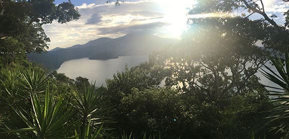
Lago de CoatepequeRuchi Patel shares this photo she took while conducting fieldwork in El Salvador this summer. Lago de Coatepeque is a large crater lake in the east part of the Coatepeque Caldera.

GOOD NEWS

Melissa Lucash, Department of Geography, Portland State University, will give a talk on “Forest resilience under climate change: Tales from the boreal forests of Alaska and beyond,” on Wednesday, September 26, 9:00 to 10:00 a.m. in 117 EES Building. The talk is co-sponsored by the Center for Landscape Dynamics and the Center for Climate Risk Management.

Supporting Women in Geography is hosting a “Climate Change Workshop” on November 9, from noon to 3:00 p.m. in 529 Walker Building, University Park campus. Anyone with interest in the topic is invited to attend, however you must register as seating is limited.  For more information and to register visit: https://www.geog.psu.edu/event/climate-change-workshop

NEWS

Please join us for a special Coffee Hour in Memory of Peirce Lewis on October 5

Colleagues, friends, family, and students of the late Geographer Peirce Lewis are invited to join us as the Department of Geography pays tribute to the man and his contributions to geography. Richard Schein (’83g), Peirce Lewis’s advisee and now professor of geography at the University of Kentucky, will give the Coffee Hour lecture. For more information about the program or to RSVP by September 28 visit: https://www.geog.psu.edu/event/coffee-hour-richard-schein

Penn State GIS Day: Visualizing the World: Connecting the disciplines through geospatial technologies and virtual reality

Penn State GIS Day events will be held on Tuesday, November 13. Penn State GIS Day events are co-sponsored by the Department of Geography and the University Libraries.

Penn State GIS Day events aim to create geospatial awareness of the many uses of geospatial technologies across disciplines, and serve as a way to connect others on campus who are using geospatial technologies.This year marks the fifth consecutive year we have been sponsoring GIS Day events. This year’s theme is: Visualizing the World: Connecting the disciplines through geospatial technologies and virtual reality.

See the Penn State GIS Day site for listings of speakers and additional information. https://sites.psu.edu/gisday/

Marion Frieswyk: The First Female Intelligence Cartographer

For 75 years, the CIA Cartography Center has been making vital contributions to our Nation’s security, providing policymakers with crucial insights that simply cannot be conveyed through words alone.

The Center’s roots stretch back even before the Office of Strategic Services (OSS)—all the way to the OSS’ predecessor, William Donovan’s Office of the Coordinator of Information (COI).

RECENTLY PUBLISHED

Human Legacies on Ecological Landscapes

Mitchell J. Power, Brian F. Codding, Alan H. Taylor, Thomas W. Swetnam, Kate E. Magargal, Douglas W. Bird and James F. O’Connell
Frontiers in Earth Science
https://www.frontiersin.org/article/10.3389/feart.2018.00151
The primacy of past human activity in triggering change in earth’s ecosystems remains a contested idea. Treating human-environmental dynamics as a dichotomous phenomenon—turning “on” or “off” at some tipping point in the past—misses the broader, longer-term, and varied role humans play in creating lasting ecological legacies. To investigate these more subtle human-environmental dynamics, we propose an interdisciplinary framework, for evaluating past and predicting future landscape change focused on human-fire legacies. Linking theory and methods from behavioral and landscape ecology, we present a coupled framework capable of explaining how and why humans make subsistence decisions and interact with environmental variation through time. We review evidence using this framework that demonstrates how human behavior can influence vegetation cover and continuity, change local disturbance regimes, and create socio-ecological systems that can dampen or even override, the environmental effects of local and regional climate. Our examples emphasize how a long-term interdisciplinary perspective provides new insights for assessing the role of humans in generating persistent landscape legacies that go unrecognized using a simple natural-versus-human driver model of environmental change.

Farm-Level Agricultural Biodiversity in the Peruvian Andes Is Associated with Greater Odds of Women Achieving a Minimally Diverse and Micronutrient Adequate Diet

Andrew D Jones, Hilary Creed-Kanashiro, Karl S Zimmerer, Stef de Haan, Miluska Carrasco, Krysty Meza, Gisella S Cruz-Garcia, Milka Tello, Franklin Plasencia Amaya, R Margot Marin, Lizette Ganoza
The Journal of Nutrition
https://doi.org/10.1093/jn/nxy166
The extent to and mechanisms by which agricultural biodiversity may influence diet diversity and quality among women are not well understood. We aimed to 1) determine the association of farm-level agricultural biodiversity with diet diversity and quality among women of reproductive age in Peru and 2) determine the extent to which farm market orientation mediates or moderates this association. We surveyed 600 households with the use of stratified random sampling across 3 study landscapes in the Peruvian Andes with diverse agroecological and market conditions. Diet diversity and quality among women were assessed by using quantitative 24-h dietary recalls with repeat recalls among 100 randomly selected women. We calculated a 10-food group diet diversity score (DDS), the Minimum Dietary Diversity for Women (MDD-W) indicator, probability of adequacy (PA) of 9 micronutrients by using a measurement-error model approach, and mean PA (MPA; mean of PAs for all nutrients). Agricultural biodiversity was defined as a count of crop species cultivated by the household during the 2016–2017 agricultural season. In regression analyses adjusting for sociodemographic and agricultural characteristics, farm-level agricultural biodiversity was associated with a higher DDS (incidence rate ratio from Poisson regression: 1.03; P < 0.05) and MPA (ordinary least-squares β-coefficient: 0.65; P < 0.1) and higher odds of achieving a minimally diverse diet (MDD-W: OR from logistic regression: 1.17; 95% CI: 1.11, 1.23) and a diet that met a minimum threshold for micronutrient adequacy (MPA >60%: OR: 1.21; 95% CI: 1.10, 1.35). Farm market orientation did not consistently moderate these associations, and in path analyses we observed no consistent evidence of mediation of these associations by farm market orientation.


18
Sep 18

Nature-Society Keynote on Friday | Peirce Lewis event | Workshop for geospatial women

IMAGE OF THE WEEK

Please join us for a special Coffee Hour in Memory of Peirce Lewis on October 5

Colleagues, friends, family, and students of the late Geographer Peirce Lewis are invited to join us as the Department of Geography pays tribute to the man and his contributions to geography. Richard Schein (’83g), Peirce Lewis’s advisee and now professor of geography at the University of Kentucky, will give the Coffee Hour lecture. For more information about the program or to RSVP by September 28 visit: https://www.geog.psu.edu/event/coffee-hour-richard-schein

GOOD NEWS

Penn State students, faculty and staff, as well as local community members (ages 18 and older) are encouraged to attend a free bike safety workshop on Tuesday, Sept. 25 from 4 p.m. to 6 p.m. at 117 Weston Community Center at Penn State’s White Course Apartments. For more information or to RSVP for the event, please visit www.biking.psu.edu.

The 2018 Department of Geography Newsletter is in the mail. If you are not currently subscribed would like to be added to the mailing list, please send your postal address to geography@psu.edu.

NATURE-SOCIETY KEYNOTE

 Trevor Birkenholtz
The Political Ecology of Drip Irrigation Infrastructure: Efficiency and Gendered Labor Dynamics in India

In this paper, I draw on a case from northern India to examine the material politics of drip irrigation infrastructure. Drip irrigation delivers water directly to plant stems or roots and has been shown to double water-use efficiency, while raising productivity, compared to conventional irrigation. It is being promoted globally by scientists, state planners and development donor agencies as a way to reduce agricultural demand for groundwater. However, while drip irrigation may enhance irrigation efficiency, it may not lead to water savings. Relying on ethnographic research conducted in India from 2015-2018, I argue that the complex interaction of subsidy policies, farmer motivations for adopting drip irrigation, and gendered labor dynamics determine whether efficiency gains in drip irrigation result in water savings. Further, I posit that feminine labor provides a subsidy to drip irrigation that underwrites both water-use efficiency and productivity, while maintaining drip irrigations’ heterogeneous material and institutional infrastructure. I conclude with a discussion of the implications of these findings for water conservation in agriculture and for gendering drip irrigation policy.

  • 3:30 to 5:00 p.m.: Refreshments are offered in 319 Walker Building at 3:30 p.m.; the lecture begins in 112 Walker Building at 4:00 p.m.
  • Coffee Hour To Go Webcast

NEWS

Women in Geospatial Sciences, Building Leaders for Tomorrow workshop

Penn State and Syracuse University will host two day-and-a-half workshops to identify challenges women currently face in U.S. universities, and provide recommendations to retain women leaders in the geospatial sciences. The workshops are open to women who work in the geospatial sciences at all career stages, including mid- and early-career faculty, staff, post-docs and graduate students.

Program combines mobile devices and the outdoors in an unlikely pairing

Alex Klippel is a project adviser
In the age of digital technology, mobile devices are good for more than just text messaging and playing games. According to Penn State College of Education researchers, the combination of technology and the outdoors is getting children and their families outside to learn more about science and their communities.

Transforming Outdoor Places into Learning Spaces is a College of Education research and development project that takes place at the Arboretum at Penn State and at Shaver’s Creek Environmental Center, Penn State’s outdoor education field lab and nature center in Petersburg, Huntingdon County. It is an opportunity for people of all ages to develop understandings of deeper learning while engaging in activities on mobile devices.

RECENTLY PUBLISHED

Surface mapping of the Milh Kharwah salt diapir to better understand the subsurface petroleum system in the Sab’atayn Basin, onshore Yemen

Tari, G., L. Jessen, P. Kennelly, A. Salman, T. Rainer and P. Hagedorn
Arabian Journal of Geosciences
https://rdcu.be/61sP
In the Sab’atayn Basin of Yemen, hydrocarbons were generated from pre-salt Upper Jurassic source rocks during the Cenozoic and the salt provides the ultimate super seal for the pre-salt and intra-salt traps. Therefore, the proper understanding of salt tectonics is critical for ongoing hydrocarbon exploration efforts targeting the fractured basement play in the Sab’atayn Basin. Based on numerous well penetrations, the presence of non-evaporitic lithologic units such as black shales, marls, carbonates, and sandstones within the Tithonian Sab’atayn Formation is quite common and quite important for the prolific Alif oil play. The internal lithologic and structural complexity of the Tithonian evaporites was addressed by analyzing a few outcropping salt diapirs east of the Habban Field area in the central part of the Sab’atayn Basin.

Witch’s Broom Disease of Lime (Candidatus Phytoplasma aurantifolia): identifying high-risk areas by climatic mapping

Donkersely, P., Blanford, J., Queiroz, R.B., Silva, F.W.S., Carvalho, C.M., Al-Sadi, A.M. Elliot, S.
Journal of Economic Entomology
https://doi.org/10.1093/jee/toy248
Biological invasions of vectorborne diseases can be devastating. Bioclimatic modeling provides an opportunity to assess and predict areas at risk from complex multitrophic interactions of pathogens, highlighting areas in need of increased monitoring effort. Here, we model the distribution of an economically critical vectorborne plant pathogen ‘Candidatus Phytoplasma aurantifolia’, the etiological agent of Witches’ Broom Disease of Lime. This disease is a significant limiting factor on acid lime production (Citrus aurantifolia, Swingle) in the Middle East and threatens its production globally. We found that temperature, humidity, and the vector populations significantly determine disease distribution. Following this, we used bioclimatic modeling to predict potential novel sites of infections. The model outputs identified potential novel sites of infection in the citrus producing regions of Brazil and China. We also used our model to explore sites in Oman where the pathogen may not be infectious, and suggest nurseries be established there. Recent major turbulence in the citrus agricultural economy has highlighted the importance of this work and the need for appropriate and targeted monitoring programs to safeguard lime production.


11
Sep 18

Cancer map | USGIF awards | Nature Society Workshop

IMAGE OF THE WEEK

Friendly Cities Lab Melbourne

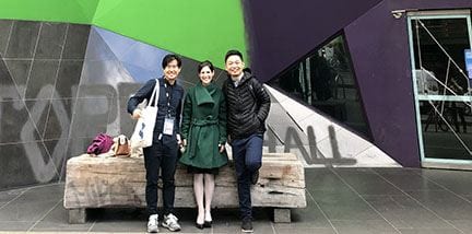
Xi Liu shares this photo of members of the Friendly Cities Lab (left to right: Hanzhou Chen, Clio Andris, Xi Liu) taken in Melbourne at GIScience 2018, held August 28–31. At GIScience 2018, the lab organized a workshop, presented two workshop papers and gave an extended abstract at the main conference. The photo was taken in front of Storey Hall at RMIT University.

GOOD NEWS

Christine Mares (’03g) is a new instructor this semester at Northern Arizona University. In addition, for the past 3.5 years she has been working at NAU for the Wildland Fire Education and Training Collaborative (WETC) as a script writer and editor, writing scripts for wildland fire educational videos. She will continue in this role as well as her new instructor duties. WETC videos are free and non-proprietary, said Mares, “so please feel free to use and share, plus we are working on new videos as we speak. Comments and suggestions are always helpful, and we welcome new collaborators!” The work is showcased here: worldofwildlandfire.org.

Guido Cervone won a grant from DARPA for his project: Expanded Dimensionality Imaging Spectroscopy via Deep Learning.

Anthony Robinson was interviewed about his research on viral maps by Fast Company for their article: “The next great fake news threat? Bot-designed maps”

NEWS

NSF funds $3 million graduate training program focused on Food-Energy-Water

The National Science Foundation has awarded a $3 million grant to an interdisciplinary team of Penn State researchers to create a new graduate program that will train students to find solutions to real-world problems facing Food-Energy-Water (FEW) systems.

The project, “Landscape-U, Impactful partnerships among graduate students and managers for regenerative landscape design,” focuses on societal issues around food, energy and water in the Chesapeake Bay watershed and globally.

Multi-campus collaboration tells story of cancer in central Pennsylvania

Geographer Brittany Waltemate worked on the map
Penn State has launched its first cancer-related Story Map, “The Story of Cancer in Central Pennsylvania.” The interactive geospatial map illustrates the extent of the cancer problem in the region. It also highlights patient navigators who help people overcome barriers to cancer care and action steps to help address cancer in the community.

Using a browser-based software called Esri ArcGIS Online, the Story Map pairs geospatial data with text and multimedia content. It allows viewers to drill down to population and cancer data at the county and sub-county levels.

USGIF Awards Highest Amount of Annual Scholarship Funds to Date

Penn Staters Carolynne Hultquist, Scott Pezanowski, Travis Meyer among winners
USGIF recently awarded $126,000 in scholarships to individuals studying GEOINT and related topics. This is the largest annual amount USGIF has distributed to date, thanks to the contributions of USGIF Organizational Members committed to investing in GEOINT education. Since the USGIF Scholarship Program began in 2004, the Foundation has awarded more than $1.2 million to students with aspirations in GEOINT.

Nature Society Workshop opens September 21 with Keynote by Trevor Birkenholtz

Penn State is hosting the 8th Nature Society Workshop on September 21–22. This informal rotating workshop began in 2010 as a space to discuss ongoing innovative scholarship in environment and society geography and to strengthen ties between Northeastern geography departments. This year Penn State hosts scholars from Clark, Rutgers, Syracuse, Cornell, Temple, and West Virginia universities.

The keynote address, which also serves in place of our usual Coffee Hour, will be given by Dr. Trevor Birkenholtz,University of Illinois Urbana–Champaign, on “The Political Ecology of Drip Irrigation Infrastructure: Efficiency and Gendered Labor Dynamics in India.” As usual, refreshments will be offered in room 319 Walker Building at 3:30 p.m., with the talk beginning at 4:00 in 112 Walker Building.

The workshop will also include a series of three interactive panel discussions on Friday and Saturday on key themes in environment and society geography, along with a short field trip on Saturday morning through Central Pa. For more information see: https://sites.psu.edu/natsocworkshop/

RECENTLY PUBLISHED

Detection of Asphalt Pavement Potholes and Cracks Based on the Unmanned Aerial Vehicle Multispectral Imagery

Yifan Pan, Xianfeng Zhang, Guido Cervone, and Liping Yang
IEEE Journal of Selected Topics in Applied Earth Observations and Remote Sensing
DOI: 10.1109/JSTARS.2018.2865528
Asphalt roads are the basic component of a landtransportation system, and the quality of asphalt roads will decrease during the use stage because of the aging and deterioration of the road surface. In the end, some road pavement distresses may appear on the road surface, such as the most common potholes and cracks. In order to improve the efficiency of pavement inspection, currently some new forms of remote sensing data without destructive effect on the pavement are widely used to detect the pavement distresses, such as digital images, light detection andmranging, and radar. Multispectral imagery presenting spatialmand spectral features of objects has been widely used in remotemsensing application. In our study, the multispectral pavement
images acquired by unmanned aerial vehicle (UAV) were used tomdistinguish between the normal pavement and pavement damagesm(e.g., cracks and potholes) using machine learning algorithms,msuch as support vector machine, artificial neural network, and random forest. Comparison of the performance between different data types and models was conducted and is discussed in this study, and indicates that a UAV remote sensing system offers a new tool for monitoring asphalt road pavement condition, which can be used as decision support for road maintenance practice.


04
Sep 18

Coffee Hour with Farshid Ahrestani | Viral maps | UROC

IMAGE OF THE WEEK

Andrew Carleton took this photo on Sedgwick Ridge, Maine, along route 172 between Blue Hill and Brooklin. It shows erratics on an old (approx. 15,000 year-old) gently-sloping glacial delta that was left as the Laurentide Ice Sheet melted/retreated from the area and the sea level rose. The surface deposits are mostly sand and gravel.

GOOD NEWS

Erica Smithwick is the recipient of an National Science Foundation Research Traineeship award for her project, “Landscape-U, Impactful Partnerships among Graduate Students and Managers for Regenerative Landscape Design” to support preparation of future leaders in the STEM workforce.

Andrew Carleton has been appointed a science team member of the National Geographic’s 2019 Everest Project, which will collect environmental samples at high and lower altitudes in the Himalayas. Carleton will help plan the climatology/meteorology section. Paul Mayewski (School of Earth Sciences, University of Maine—Orono) is Science Leader.

The PAC Herbarium announces its fall workshop series.  All workshops take place from 6:00 to 8:00 p.m. at the PAC Herbarium, 10 Whitmore Lab. Workshops are free to Penn State students, staff, and faculty, as well as the interested public, but registration is required. Contact Curator Sarah Chamberlain at sjm20@psu.edu to register.

  • September 13: Getting to Know the Goldenrods
  • October 11: Shady Invaders!
  • November 8: Grasses of the Mid-Atlantic
  • December 5: Evergreen trees of Pennsylvania

COFFEE HOUR

Coffee Hour with Farshid Ahrestani: The distribution of large herbivores over time and space in South and Southeast Asia

The large herbivores of South and Southeast Asia comprise an ancient and diverse guild with a long history of association with humans. To this day, our knowledge of the mechanisms that have shaped the distribution of these herbivores over space and time, and the ecological roles they play in ecosystems, remains largely inadequate.

  • 3:30 to 5:00 p.m.: Refreshments are offered in 319 Walker Building at 3:30 p.m.; the lecture begins in 112 Walker Building at 4:00 p.m.
  • Coffee Hour To Go Webcast

NEWS

Researcher asks ‘what causes maps to go viral’ on the web

As the 2016 presidential election was heating up, the statistical news website FiveThirtyEight released a projection map asking what if only women voted.

The map, sent out in a tweet by FiveThirtyEight founder Nate Silver, quickly went viral on social media and was viewed millions of times. That viral cartography event, and what quickly followed, is the subject of research conducted by Anthony Robinson, assistant professor of geography at Penn State.

UROC accepting student applications now

The Department of Geography’s Undergraduate Research Opportunities Connection (UROC) program allows undergraduate students to gain valuable research experience and technical skills through collaboration on projects within the department and supervised by faculty and/or graduate students, as well as 1-3 credit hours to apply towards graduation (GEOG 494). This is a valuable resume-building experience for undergraduate students and can be beneficial for both future employment and graduate school. Information on current and past projects is available at https://sites.psu.edu/uroc/

RECENTLY PUBLISHED

Small-scale crisis responde mapping: Comparing user contributions to events in OpenStreetMap

Kamptner, Erika and Kessler, Fritz
GeoJournal
doi: 10.1007/s10708-018-9912-1
In the last decade, the crowdsourced geographic information platform, OpenStreetMap (OSM), has become a critical tool for emergency response efforts during large-scale crisis events such as hurricanes, typhoons and earthquakes. Events such as the 2010 Haiti earthquake, have attracted massive organized relief responses on the OSM platform. During these events, new and experienced OSM contributors have helped map critical infrastructure necessary for relief efforts. While much is understood about how OSM users organized and contributed during these large-scale events, little has been researched as to how contributors respond to smaller scale events. This study investigates how OSM users contribute to the map in response to small-scale crisis events by comparing OSM user contributions from four recent building fire incidents located in Western and Non-Western countries and areas of varying degrees of map completeness.

Map Projection Education in Cartography Textbooks

Kessler, Fritz
Cartographic Perspectives
doi: 10.14714/CP90.1449
As developments in the field of map projections occur (e.g., the deriving of a new map projection), it would be reasonable to expect that those developments that are important from a teaching standpoint would be included in cartography textbooks. However, researchers have not examined whether map projection material presented in cartography textbooks is keeping pace with developments in the field and whether that material is important for cartography students to learn. To provide such an assessment, I present the results of a content analysis of projection material discussed in 24 cartography textbooks published during the 20 th and early 21 st centuries.


Skip to toolbar