
Yes its only the middle of October but it SNOWED this weekend! We better get used to it because State College receives on average 45 inches of snow annually. That is why we should take the time to learn what the white stuff is and EVERYTHING associated with it.

http://jokideo.com/bosses-be-like-snow-meme/
Snow is created in Nimbostratus or Stratus clouds that are below the freezing point where the water vapor does not go through a liquid phase and sublimates directly into ice crystals. But that is a very basic definition, snow is much more complicated than we may think. According to the National Snow and Ice Data Center there are three major types of snow crystals:
Snowflakes:The first is the one we know well. As I said earlier they are ice crystals that fall from clouds. It is interesting that although they are made of clear ice, snowflakes appear white due to diffuse reflection of the whole light spectrum from small crystal facets in the snow.
Hoarfrost: like snow, Hoarfrost goes directly from a vapor to a solid but does not fall as snow would. Instead it is the ice we would see forming on smaller objects exposed to the air like power lines. It forms when the temperature of a surface is lower than the frost point of the surrounding air and the moisture freezes directly to a surface.
Graupel: Graupel begins life as a snowflake but encounters and collects supercooled water droplets as it falls to the surface. The water droplets can be at temperatures as low as -40°F and freeze on a snowflake to form a white ball. Graupel is sometimes referred to as soft hail because it is not a hard frozen ice ball and can often break apart on impact with the surface and can easily be broken up. It is also not to be confused with sleet which is liquid rain that falls from a cloud in and freezes in the air before it reaches the surface.
You may also notice how calm and quiet it is during a snow storm and directly after. This is because the fresh snow absorbs sound and lowers the ambient noise. This occurs because the air that is trapped in between the snowflakes can lower vibration. But, this quality is quickly lost as snow becomes more packed down and can even be reversed as ice falls or forms a layer on top of the snow.
Those were just the different types of snow crystals, there are also many different types of snowfall. Flurries fall for short periods and create no accumulation (Like the past weekend). Snow squalls are a short but intense snowfall that decreases visibility due to strong winds or heavy snow. Finally, snow bursts are short but intense snow showers that greatly decrease visibility. Unlike a snow squall, snow bursts often create periods of very rapid snow accumulation and are not accompanied by strong winds. Short duration in the case of a snow burst can mean anywhere from 1-24 hours of snowfall rates around 2 inches or greater throughout the duration. They are often a much more contained area in a larger storm.
We know snowstorms will become a common occurrence the further we move in the semester. With that we become familiar with hearing The National Weather Service (NWS) State College Office posting warnings for winter weather but it is important to know what every one actually means. In order for the NWS to post a watch or warning, the criteria (Updated for the 2015-16 winter) detailed below must first be met:
- Winter Weather Advisory:

- For Snow events:
- 12 Hour outlook: Greater than 3 inches of snow expected
- For Combination Events (Ice and Snow):
- A combination of snow sleet and or freezing rain. No accumulation threshold Listed.
- For Snow events:
- Winter Storm Watch:
- For Snow Events:
- The Possibility that the criteria for a Winter Storm Warning may be met. Watches are generally posted 24-28 hours before a storm is to occur.
- For Combination Events:
 The possibility that the criteria for a Winter Storm OR Ice Warning may be met.
- For Snow Events:
- Winter Storm Warning:
- For Snow Events:
- 12 Hour Outlook: Greater than 6 inches of snow expected.
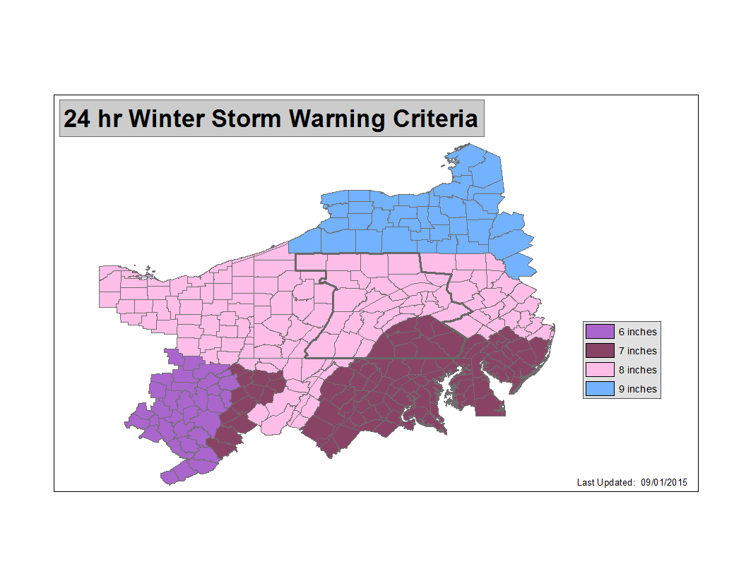
- 24 Hour Outlook: Greater than 8 inches of snow expected.

- For Combination Events:
- 6 inches or more of snow with some ice accumulation OR 1/4 inch of ice with any snow or sleet.
- For Snow Events:
- Blizzard Watch:
- The Possibility that the criteria for a blizzard warning will be met (24-48 Hours)
- Blizzard Warning (Lets Hope we don’t hear this one)

- A considerable amount of falling and or blowing snow along with sustained winds or frequent gusts of 35mph or greater with visibilities of less than 1/4 mile for a period of 3 hours or greater.
(Images Courtesy of The National Weather Service)
So now that we know more then we ever wanted to about every aspect of snowfall and more lets grab our boots and hats and get ready for the long long haul. Brace Yourselves, WINTER IS COMING! (Image Courtesy of Everydaysciencestuff.com)